The Spanish conquest of Yucatán was the campaign undertaken by the Spanish conquistadores against the Late Postclassic Maya states and polities in the Yucatán Peninsula, a vast limestone plain covering south-eastern Mexico, northern Guatemala, and all of Belize. The Spanish conquest of the Yucatán Peninsula was hindered by its politically fragmented state. The Spanish engaged in a strategy of concentrating native populations in newly founded colonial towns. Native resistance to the new nucleated settlements took the form of the flight into inaccessible regions such as the forest or joining neighbouring Maya groups that had not yet submitted to the Spanish. Among the Maya, ambush was a favoured tactic. Spanish weaponry included broadswords, rapiers, lances, pikes, halberds, crossbows, matchlocks, and light artillery. Maya warriors fought with flint-tipped spears, bows and arrows and stones, and wore padded cotton armour to protect themselves. The Spanish introduced a number of Old World diseases previously unknown in the Americas, initiating devastating plagues that swept through the native populations.
Petén is a department of Guatemala. It is geographically the northernmost department of Guatemala, as well as the largest by area – at 35,854 km2 (13,843 sq mi) it accounts for about one third of Guatemala's area. The capital is Flores. The population at the mid-2018 official estimate was 595,548.

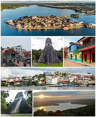
Flores is the capital of the Petén Department, Guatemala's landlocked, northernmost department. The population is 13,700 (2003).
Martín de Ursúa y Arizmendi, Count of Lizárraga and of Castillo, was a Spanish conquistador in Central America during the late colonial period of New Spain. Born in Olóriz, Navarre, he is noted for leading the 1696–97 expeditionary force which resulted in the fall of the last significant independent Maya stronghold, Nojpetén, located on an island in Lake Petén Itzá in the northern Petén Basin region of present-day Guatemala. He served as governor of the Yucatán until 1708, when he was named Governor-General of the Philippines. Around the time that he was named to that post, he was made a knight of the Order of Santiago. He died in Manila in 1715.

The Itza are a Maya ethnic group native to the Péten region of northern Guatemala and parts of Belize. The majority of Itza are inhabitants of the city of Flores on Lake Petén Itzá, and nearby portions of Belize where they form an ethnic minority.
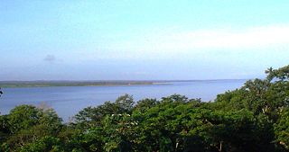
Lake Petén Itzá is a lake in the northern Petén Department in Guatemala. It is the third largest lake in Guatemala, after Lake Izabal and Lake Atitlán. It is located around 16°59′0″N89°48′0″W. It has an area of 99 km2 (38 sq mi), and is some 32 km (20 mi) long and 5 km (3.1 mi) wide. Its maximum depth is 160 m (520 ft). The lake area presents high levels of migration, due to the existence of natural resources such as wood, chewing gum, oil, and agricultural and pasture activities. Because of its archaeological richness, around 150,000 tourists pass through this region yearly. The city of Flores, the capital of the Petén Department, lies on an island near its southern shore.
Itzaʼ is an endangered Mayan language spoken by the Itza people near Lake Peten Itza in north-central Guatemala and neighboring Belize. The language has about 1,000 fluent speakers, all older adults.
The Petén Basin is a geographical subregion of the Maya Lowlands, primarily located in northern Guatemala within the Department of El Petén, and into the state of Campeche in southeastern Mexico.
Ixlu is a small Maya archaeological site that dates to the Classic and Postclassic Periods. It is located on the isthmus between the Petén Itzá and Salpetén lakes, in the northern Petén Department of Guatemala. The site was an important port with access to Lake Petén Itzá via the Ixlu River. The site has been identified as Saklamakhal, also spelt Saclemacal, a capital of the Kowoj Maya.
The Kowoj [koʔwox] was a Maya group and polity, from the Late Postclassic period of Mesoamerican chronology. The Kowoj claimed to have migrated from Mayapan sometime after the city's collapse in 1441 AD. Indigenous documents also describe Kowoj in Mayapan and linguistic data indicate migrations between the Yucatán Peninsula and the Petén region.

The Spanish conquest of the Maya was a protracted conflict during the Spanish colonisation of the Americas, in which the Spanish conquistadores and their allies gradually incorporated the territory of the Late Postclassic Maya states and polities into the colonial Viceroyalty of New Spain. The Maya occupied the Maya Region, an area that is now part of the modern countries of Mexico, Guatemala, Belize, Honduras and El Salvador; the conquest began in the early 16th century and is generally considered to have ended in 1697.

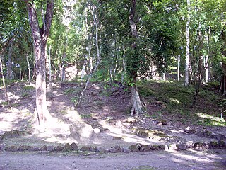
Nojpetén was the capital city of the Itza Maya kingdom of Petén Itzá. It was located on an island in Lake Petén Itzá in the modern department of Petén in northern Guatemala. The island is now occupied by the modern town of Flores, the capital of the Petén department, and has had uninterrupted occupation since pre-Columbian times. Nojpetén had defensive walls built upon the low ground of the island, which may have been hastily constructed by the Itza at a time when they felt threatened either by the encroaching Spanish or by other Maya groups.
Kan Ekʼ was the name or title used by the Itza Maya kings at their island capital Nojpetén upon Lake Petén Itzá in the Petén Department of Guatemala. The full title was Aj Kan Ekʼ or Ajaw Kan Ekʼ , and in some studies Kan Ekʼ is used as the name of the Late Postclassic Petén Itza polity.

The Yalain have been proposed as a Maya polity that existed during the Postclassic period in the Petén Basin of northern Guatemala, based in the central Petén lakes region. A small town called Yalain was described in 1696 by the Franciscan friar Andrés de Avendaño y Loyola. It was said to consist of a relatively small number of residences clustered within rich agricultural land. The town was located to the east of Lake Petén Itzá and was said to have been farmed by the inhabitants of Nojpetén, the capital city of the Itza kingdom. The political extent and archaeology of the Yalain is poorly understood.
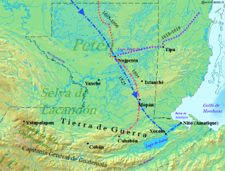
The Spanish conquest of Petén was the last stage of the conquest of Guatemala, a prolonged conflict during the Spanish colonisation of the Americas. A wide lowland plain covered with dense rainforest, Petén contains a central drainage basin with a series of lakes and areas of savannah. It is crossed by several ranges of low karstic hills and rises to the south as it nears the Guatemalan Highlands. The conquest of Petén, a region now incorporated into the modern republic of Guatemala, climaxed in 1697 with the capture of Nojpetén, the island capital of the Itza kingdom, by Martín de Ursúa y Arizmendi. With the defeat of the Itza, the last independent and unconquered native kingdom in the Americas fell to European colonisers.
The Kejache were a Maya people in northern Guatemala at the time of Spanish contact in the 17th century. The Kejache territory was located in the Petén Basin in a region that takes in parts of both Guatemala and Mexico. Linguistic evidence indicates that the Kejache shared a common origin with the neighbouring Itzas to their southeast and the Kejache may have occupied the general region since the Classic period. The Kejache were initially contacted by conquistador Hernán Cortés in 1525; they were later in prolonged contact with the Spanish as the latter opened a route southwards towards Lake Petén Itzá.

The Peten Itza kingdom was a kingdom centered on the island-city of Nojpetén on Lake Peten Itza.

The Chinamitas or Tulumkis were likely a Mopan Maya people who constituted the former Chinamita Territory, an early Columbian polity of the Maya Lowlands, likely in present-day Belize and Guatemala. In the early 17th century, the Territory probably lay along the Mopan River in the eastern Petén Basin and neighbouring portions of western Belize, being thereby situated east of the Itza of Nojpetén, south of the Yaxhá and Sacnab lakes, and west of Tipuj.
The history of Maya civilization is divided into three principal periods: the Preclassic, Classic and Postclassic periods; these were preceded by the Archaic Period, which saw the first settled villages and early developments in agriculture. Modern scholars regard these periods as arbitrary divisions of chronology of the Maya civilization, rather than indicative of cultural evolution or decadence. Definitions of the start and end dates of period spans can vary by as much as a century, depending on the author. The Preclassic lasted from approximately 3000 BC to approximately 250 AD; this was followed by the Classic, from 250 AD to roughly 950 AD, then by the Postclassic, from 950 AD to the middle of the 16th century. Each period is further subdivided:
Nixtun-Chʼichʼ is an Itza Maya archaeological site in Petén Department, Guatemala. It has an urban grid with fairly well ordered streets and avenues dated to around 2500 years ago. This is one of the earliest urban grids in the Americas and likely emerged as the ancient Maya developed more complex forms of political organization. It was likely a means to regulate and perhaps dominate the inhabitants. Nevertheless, the grid system at Nixtun-Chʼichʼ did not catch on and is not seen in later Maya cities.