
The British Virgin Islands are located in the Caribbean, between the Caribbean Sea and the North Atlantic Ocean, east of Puerto Rico.Its geographic coordinates are 18°30′N64°30′W. Map references include Central America and the Caribbean. The area totals 151 km² and comprises 16 inhabited and more than 20 uninhabited islands; includes the islands of Tortola, Anegada, Virgin Gorda and Jost van Dyke. There are no bodies of water on the land. There are no land boundaries. There is 80 km of coastline. Maritime claims include 3 nmi of territorial sea and exclusive a 200 nmi fishing zone. It has a tropical, humid climate, with temperatures moderated by trade winds. Its terrain consists of coral islands, and is relatively flat. It has volcanic islands and is steep and hilly. Its lowest point is the Caribbean Sea and its highest point is Mount Sage at 521 metres (1,709 ft) above sea level. Its natural resources are negligible. In terms of land use, it is 20% arable land, 6.67% permanent crops and 73.33% other as of a 2005 figure. Its natural hazards consist of hurricanes and tropical storms from July to October. There is limited natural fresh water resources. It has strong ties to nearby U.S. Virgin Islands and Puerto Rico.

Geography of the United States Virgin Islands

The Virgin Islands are geologically and biogeographically the easternmost part of the Greater Antilles, the northern islands belonging to the Puerto Rican Bank and St. Croix being a displaced part of the same geologic structure. Politically, the British Virgin Islands have been governed as the western island group of the Leeward Islands, which are the northern part of the Lesser Antilles, and form the border between the Caribbean Sea and the Atlantic Ocean. The archipelago is separated from the true Lesser Antilles by the Anegada Passage and from the main island of Puerto Rico by the Virgin Passage.

Cruz Bay, U.S. Virgin Islands is the main town on the island of Saint John in the United States Virgin Islands. According to the 2000 census, Cruz Bay had a population of 2,743.
The area code (340) is the local telephone area code of U.S. Virgin Islands. The (340) area code was created during a split from the original (809) area code, which began permissive dialing on 1 June 1997 and ended 30 June 1998.
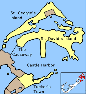
St. George's Parish is one of the nine parishes of Bermuda. It is named after the founder of the Bermuda colony, Admiral Sir George Somers.

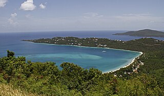
Magens Bay is a bay in the Northside region on Saint Thomas, United States Virgin Islands, located in the Caribbean.
Flanagan Island is an island located within the Virgin Islands archipelago in the Caribbean and forms part of the U.S. Virgin Islands.
Resolution is a settlement on the island of Saint Thomas in the United States Virgin Islands. It is part of the Northside Administrative District. Crown Mountain, the highest point in the US Virgin Islands, is in Resolution.

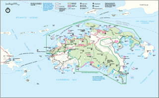
Annaberg is a former sugar factory and plantation on the island of Saint John in the United States Virgin Islands. It is uninhabited and part of the Annaberg Historic District within the Virgin Islands National Park.
Bordeaux is a neighborhood on the island of Saint John in the United States Virgin Islands. It is named for Mount Bordeaux, the highest point on the island. Most of this area is part of Virgin Islands National Park.
Fish Bay is a bay and neighborhood on the island of Saint John in the United States Virgin Islands. Most of this area is part of Virgin Islands National Park.
Lameshur is a former plantation on the island of Saint John in the United States Virgin Islands. It is inside Virgin Islands National Park and home to the Virgin Islands Environmental Resource Station (VIERS). The Tektite program placed two underwater habitats in Great Lameshur Bay and the Tektite Underwater Habitat Museum is located in the VIERS camp. The road to Lameshur is unmaintained and 4 wheel drive vehicles are often required. The University of the Virgin Islands has a research station and dock in Lameshur on Yawzi Point.
Mary Point is an uninhabited peninsula on the island of Saint John in the United States Virgin Islands. There are no roads or trails and steep cliffs prevent access from the water. Although Mary Point once housed a small sugar cane plantation, the area is now overgrown with thick forest. The foundation and crumbling walls of Mary Point Estate can be seen from the Francis Bay trail. It is part of Virgin Islands National Park. Mary Creek, the shallow bay on the east side, is a popular spot for fly fishing and kitesurfing.
Sandy Point is a settlement on the island of Saint Croix in the United States Virgin Islands.

School Knott is a hill in the Lake District, England, to the east of Windermere town, Cumbria. It is the subject of a chapter of Wainwright's book The Outlying Fells of Lakeland. His recommended route starts at Windermere railway station and includes Grandsire at 818 feet (249 m) and a nameless summit at 806 feet (246 m). The summit is at 760 feet (230 m) and offers a view of four sections of Windermere, the lake. It has a rocky outcrop but no trig point and, as reported by Wainwright, no cairn. Schoolknott Tarn is to the south-east of the summit.
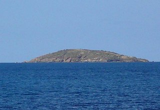
Leduck Island is an island in the United States Virgin Islands, also spelled LeDuck Island, which is located 0.5 miles east of Sabbat Point in Johns Folly, separated from Saint John by the Sabbat Channel. LeDuck Island lies by the entrance to Coral Bay and is 85 feet high. Leduck Island is located within the Virgin Islands National Park and is one of the largest offshore islands to Saint John, along with Grass Cay and Congo Cay. Being home to numerous spur and groove reefs, it is a popular scuba diving destinations and its reefs are habitat for an abundance for endemic tropical fish species. Some of the fish species found here include the Fairy basslet, Sergeant major, French angelfish, Gray angelfish, Queen triggerfish, Jackknife-fish, Blue chromis, Schoolmaster snapper, Mangrove snapper, Red hind, Blacktip shark, Hawksbill sea turtle, Glassy sweeper, Squirrelfish, and numerous species of damsels and jacks.
Northside with its population of 10,049 as of the 2010 United States Census is the second-most populous administrative census subdistrict (CSD) on Saint Thomas, only less populated than the Charlotte Amalie subregion with the islands’ territorial capital of more than 18,000 people. Northside is sometimes called Nordside in Virgin Islands Creole, which is the Danish translation for north side. Northside is home to communities such as Neltjeberg, Zambee, Resolution, Ensomned, Barrett, Solberg, Lerkenlund, Misgen, Mafolie, Louisenhoj, Estate Thomas, Mandal, Enighed, Canaan, and Peterborg. By area, the Northside subdistrict is the largest administrative census sub-district on the Saint Thomas island.

Wayne is an unincorporated community in Webster Township, Wayne County, in the U.S. state of Indiana.

