Egyptian describes something of, from, or related to Egypt.
Plague or The Plague may refer to:

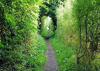
A footpath is a type of thoroughfare that is intended for use only by pedestrians and not other forms of traffic such as motorized vehicles, bicycles and horses. They can be found in a wide variety of places, from the centre of cities, to farmland, to mountain ridges. Urban footpaths are usually paved, may have steps, and can be called alleys, lanes, steps, etc.
Amber is a fossilized tree resin.
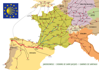
The Camino de Santiago, or in English the Way of St. James, is a network of pilgrims' ways or pilgrimages leading to the shrine of the apostle James in the cathedral of Santiago de Compostela in Galicia in northwestern Spain, where tradition holds that the remains of the apostle are buried.

The Via Francigena is an ancient road and pilgrimage route running from the cathedral city of Canterbury in England, through France and Switzerland, to Rome and then to Apulia, Italy, where there were ports of embarkation for the Holy Land. It was known in Italy as the "Via Francigena" or the "Via Romea Francigena". In medieval times it was an important road and pilgrimage route for those wishing to visit the Holy See and the tombs of the apostles Peter and Paul.

The Pilgrims' Way is the historical route supposedly taken by pilgrims from Winchester in Hampshire, England, to the shrine of Thomas Becket at Canterbury in Kent. This name, of comparatively recent coinage, is applied to a pre-existing ancient trackway dated by archaeological finds to 600–450 BC, but probably in existence since the Stone Age. The prehistoric route followed the "natural causeway" east to west on the southern slopes of the North Downs.
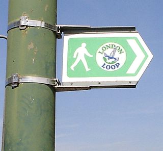
The London Outer Orbital Path — more usually the "London LOOP" — is a 150-mile (242 km) signed walk along public footpaths, and through parks, woods and fields around the edge of Outer London, England, described as "the M25 for walkers". The walk begins at Erith on the south bank of the River Thames and passes clockwise through Crayford, Petts Wood, Coulsdon, Banstead, Ewell, Kingston upon Thames, Uxbridge, Elstree, Cockfosters, Chingford, Chigwell, Grange Hill and Upminster Bridge before ending at Purfleet, almost directly across the Thames from its starting point. Between these settlements the route passes through green buffers and some of the highest points in Greater London.
St Swithun's Way is a 34-mile (55 km) long-distance footpath in England from Winchester Cathedral, Hampshire to Farnham, Surrey. It is named after Swithun, a 9th-century Bishop of Winchester, and roughly follows the Winchester to Farnham stretch of the Pilgrims' Way. The route was opened in 2002 to mark the Golden Jubilee of Elizabeth II.
A pilgrim is one who undertakes a religious journey or pilgrimage.

Historic roads are paths or routes that have historical importance due to their use over a period of time. Examples exist from prehistoric times until the early 20th century. They include ancient trackways, long-lasting roads, important trade routes, and migration trails. Many historic routes, such as the Silk Road, the Amber Road, and the Royal Road of the Persian Empire, covered great distances and their impact on human settlements remain today.
Canada is a country in North America.

The Harrow Way is another name for the "Old Way", an ancient trackway in the south of England, dated by archaeological finds to 600–450 BC, but probably in existence since the Stone Age. The Old Way ran from Seaton in Devon to Dover, Kent. Later the eastern part of the Harrow Way become known as the Pilgrims' Way in the 19th century: the latter was a route invented by Albert Way of the Ordnance Survey, who imagined it to have been a pilgrimage route which ran from Winchester, Hampshire, via Farnham, Surrey, to Canterbury Kent. The western section of the Harrow Way ends in Farnham, the eastern in Dover.
The Confraternity of Saint James is a pilgrims' association, educational charity and book publisher for the ancient and modern-day pilgrim route Camino de Santiago or "way of Saint James" to the city of Santiago de Compostela in Galicia in northern Spain.

Sandling is a hamlet to the north of the town of Maidstone, Kent, England, at the foot of the North Downs. It falls within the parish of Boxley.

Scott Pilgrim vs. the World is a 2010 romantic action comedy film co-written, produced, and directed by Edgar Wright, based on the graphic novel series Scott Pilgrim by Bryan Lee O'Malley. It stars an ensemble cast, with Michael Cera as Scott Pilgrim, a slacker musician who is trying to win a competition to get a record deal while also battling the seven evil exes of his newest girlfriend Ramona Flowers, played by Mary Elizabeth Winstead.
Beulah is a term from the Biblical Hebrew to refer to the Lord's country, Beulah (land). It may also refer to:
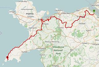
The North Wales Pilgrim's Way is a long-distance walking route in North Wales, running from near Holywell in the east to Bardsey Island in the west. The first half of the trail takes an inland route, with the second half following the north coast of the Llŷn Peninsula. It measures 133.9 miles (215 km) in length, and was officially launched at Porth y Swnt, Aberdaron on 10 July 2014.