| Look up Pillsbury in Wiktionary, the free dictionary. |
Pillsbury may refer to:
| Look up Pillsbury in Wiktionary, the free dictionary. |
Pillsbury may refer to:
Silver Lake may refer to:

The Driftless Area is a region in southwestern Wisconsin, southeastern Minnesota, northeastern Iowa, and the extreme northwestern corner of Illinois, of the American Midwest. The region escaped the flattening effects of glaciation during the last ice age and is consequently characterized by steep, forested ridges, deeply carved river valleys, and karst geology characterized by spring-fed waterfalls and cold-water trout streams. Ecologically, the Driftless Area's flora and fauna are more closely related to those of the Great Lakes region and New England than those of the broader Midwest and central Plains regions. Colloquially, the term includes the incised Paleozoic Plateau of southeastern Minnesota and northeastern Iowa. The region includes elevations ranging from 603 to 1,719 feet at Blue Mound State Park, and covers 24,000 square miles (62,200 km2). The rugged terrain is due both to the lack of glacial deposits, or drift, and to the incision of the upper Mississippi River and its tributaries into bedrock.
Chimney Rock can refer to one of the following sites in the United States and Canada:

The North Shore of Lake Superior runs from Duluth, Minnesota, United States, at the southwestern end of the lake, to Thunder Bay and Nipigon, Ontario, Canada, in the north to Sault Ste. Marie, Ontario, in the east. The shore is characterized by alternating rocky cliffs and cobblestone beaches, with forested hills and ridges through which scenic rivers and waterfalls descend as they flow to Lake Superior.

Interstate Park comprises two adjacent state parks on the Minnesota–Wisconsin border, both named Interstate State Park. They straddle the Dalles of the St. Croix River, a deep basalt gorge with glacial potholes and other rock formations. The Wisconsin park is 1,330 acres (538 ha) and the Minnesota park is 298 acres (121 ha). The towns of Taylors Falls, Minnesota and St. Croix Falls, Wisconsin are adjacent to the park. Interstate Park is within the Saint Croix National Scenic Riverway and the Ice Age National Scientific Reserve. The western terminus of the Ice Age National Scenic Trail is on the Wisconsin side. On the Minnesota side, two areas contain National Park Service rustic style buildings and structures that are listed on the National Register of Historic Places.
Pillsbury Crossing is a natural limestone slab that was used by pioneers to cross Deep Creek. The ledge terminates in a waterfall in Riley County, Kansas, USA. The waterfall is about 40 feet (12 m) wide and has a drop of around 5 feet (1.5 m). Below Pillsbury Crossing, Deep Creek flows into the Kansas River.
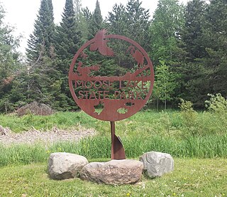
Moose Lake State Park is a state park of Minnesota, USA, near the city of Moose Lake, MN in Carlton County. The park is located one-half mile east of Interstate 35 at the 214 exit. The park entrance is off of County Highway 137. Moose Lake State Park was established in 1971. In total, the park is 1,194 acres in area. Some of the highlights of the park include 5.5 miles of hiking trails, a 105-acre Echo Lake, wildlife pond, paved trail to Moose Lake and Willard Munger State Trail, and Agate/Geological Interpretive Center; located within the park office.

The geology of Minnesota comprises the rock, minerals, and soils of the U.S. state of Minnesota, including their formation, development, distribution, and condition.

Minnesota is the northernmost state outside Alaska; its isolated Northwest Angle in Lake of the Woods is the only part of the 48 contiguous states lying north of the 49th parallel. Minnesota is in the U.S. region known as the Upper Midwest. The state shares a Lake Superior water border with Michigan and Wisconsin on the northeast; the remainder of the eastern border is with Wisconsin. Iowa is to the south, North Dakota and South Dakota are west, and the Canadian provinces of Ontario and Manitoba are north. With 87,014 square miles (225,370 km2), or approximately 2.26 % of the United States, Minnesota is the 12th largest state.

The Midcontinent Rift System (MRS) or Keweenawan Rift is a 2,000 km (1,200 mi) long geological rift in the center of the North American continent and south-central part of the North American plate. It formed when the continent's core, the North American craton, began to split apart during the Mesoproterozoic era of the Precambrian, about 1.1 billion years ago. The rift failed, leaving behind thick layers of igneous rock that are exposed in its northern reaches, but buried beneath later sedimentary formations along most of its western and eastern arms. Those arms meet at Lake Superior, which is contained within the rift valley. The lake's north shore in Ontario and Minnesota defines the northern arc of the rift. From the lake, the rift's eastern arm trends south to central lower Michigan, and possibly into Indiana, Ohio, Kentucky, Tennessee, and Alabama. The western arm runs from Lake Superior southwest through portions of Wisconsin, Minnesota, Iowa, and Nebraska to northeastern Kansas, and possibly into Oklahoma.

Palisade Head is a large rock formation on the North Shore of Lake Superior in the U.S. state of Minnesota. It is within Tettegouche State Park but not contiguous with the rest of that park. Palisade Head is located at milepost 57 on scenic Minnesota State Highway 61 in Lake County, approximately 54 miles (86 km) northeast of Duluth and 3 miles northeast of Silver Bay.

The Duluth Complex, the related Beaver Bay Complex, and the associated North Shore Volcanic Group are rock formations which comprise much of the basement bedrock of the northeastern part of the U.S. state of Minnesota in central North America. The Duluth and Beaver Bay complexes are intrusive rocks formed about 1.1 billion years ago during the Midcontinent Rift; these adjoin and are interspersed with the extrusive rocks of the North Shore Volcanic Group produced during the same geologic event. These formations are part of the Superior Upland physiographic region of the United States, which is associated with the Laurentian Upland of the Canadian Shield, the core of the North American Craton.

Crane Lake is an unincorporated community in Crane Lake Township, Saint Louis County, Minnesota, United States; located within the Kabetogama State Forest.
Lura may refer to:
The Rove Formation, is a sedimentary rock formation of Middle Precambrian age underlying the upper northeastern part of Cook County, Minnesota, United States, and extending into Ontario, Canada. It is the youngest of the many layers of sedimentary rocks which constitute the Animikie Group.
The Pillsbury State Forest is a state forest located in Cass County, Minnesota. Created in 1900, it was the first designated Minnesota state forests. The forest borders Gull Lake and the city of Lake Shore to the north. The forest is managed by the Minnesota Department of Natural Resources. The name of the forest is derived from John S. Pillsbury, the former Governor of Minnesota, who donated the original 1,000 acres (4.0 km2) of land that became the state forest.
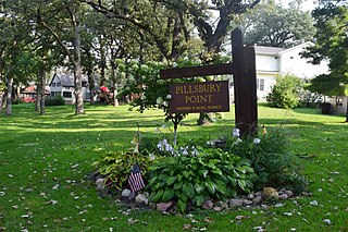
Pillsbury Point State Park is located in Arnolds Park, Iowa, United States. It is Iowa's smallest state park and unlike the others, it is an urban park. At 6.48 acres (2.62 ha), it is a narrow park that extends along a point of land into West Okoboji Lake adjacent to private summer houses. The overlook at the north end of the park was listed on the National Register of Historic Places in 1990. The historic designation includes walkways along the lake, stone steps, stone benches, and property boundary markers.

Mini-Wakan State Park is located north of Spirit Lake, Iowa, United States. The 20-acre (8.1 ha) park is along the north shore of Big Spirit Lake. It provides space for picnicking, hiking, biking, swimming, boating and fishing on the lake. The park is connected to the Dickinson County trail system in Iowa and the Jackson County trail system in Minnesota. It was listed as a historic district on the National Register of Historic Places in 2010.
Mount Sunapee State Park is a public recreation area in Newbury, New Hampshire. The state park's nearly 3,000 acres (1,200 ha) include most of Mount Sunapee and a beach area on Lake Sunapee. Park activities include swimming, hiking, camping, skiing, fishing, picnicking, and non-motorized boating. The park's ski area is operated as Mount Sunapee Resort under the management of Vail Resorts Inc.
Pillsbury, also spelled Pilsbury, is a surname. Notable people with the name include: