
Utah County is the second-most populous county in the U.S. state of Utah. The county seat and largest city is Provo, which is the state's third-largest city, and the largest outside of Salt Lake County. As of the 2020 United States Census, the population was 665,665.
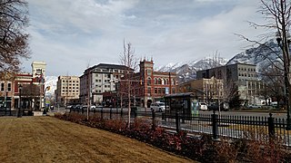
Provo is the fourth-largest city in Utah, United States. It is 43 miles (69 km) south of Salt Lake City along the Wasatch Front. Provo is the largest city and county seat of Utah County and is home to Brigham Young University (BYU).
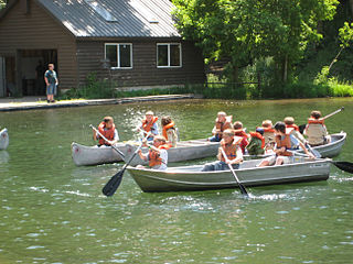
Scouting in Utah has a long history, from the 1910s to the present day, serving thousands of youth in programs that suit the environment in which they live.

The Uinta Mountains are an east-west trending chain of mountains in northeastern Utah extending slightly into southern Wyoming in the United States. As a subrange of the Rocky Mountains, they are unusual for being the highest range in the contiguous United States running east to west, and lie approximately 100 miles (160 km) east of Salt Lake City. The range has peaks ranging from 11,000 to 13,528 feet, with the highest point being Kings Peak, also the highest point in Utah. The Mirror Lake Highway crosses the western half of the Uintas on its way to Wyoming.
Pleasant Valley may refer to:
Pine Valley may refer to:

Utah Valley is a valley in North Central Utah located in Utah County, and is considered part of the Wasatch Front. It contains the cities of Provo, Orem, and their suburbs, including Alpine, American Fork, Cedar Hills, Elk Ridge, Highland, Lehi, Lindon, Mapleton, Payson, Pleasant Grove, Salem, Santaquin, Saratoga Springs, Spanish Fork, Springville, Vineyard and Woodland Hills. It is known colloquially as "Happy Valley".

The Heber Valley Railroad (HVRX) is a heritage railroad based in Heber City, Utah. It operates passenger excursion trains along a line between Heber City and Vivian Park, which is located in Provo Canyon. The HVRX carries over 110,000 passengers a year.
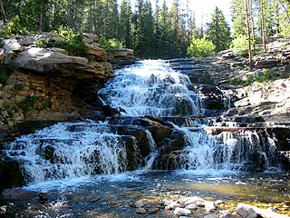
The Provo River is located in Utah County and Wasatch County, Utah, in the United States. It rises in the Uinta Mountains at Wall Lake and flows about 71 miles (114 km) southwest to Utah Lake at the city of Provo, Utah.
Provo or Provos may refer to:

State Route 265 is a west–east thoroughfare completely within Utah County in northern Utah that cuts through Orem and Provo. Utah Valley University and Brigham Young University are in close proximity to SR-265. The entirety of the route is named University Parkway.

Provo Canyon is located in unincorporated Utah County and Wasatch County, Utah. Provo Canyon runs between Mount Timpanogos on the north and Mount Cascade on the south. The canyon extends from Orem on the west end to Heber City on the east. Provo Canyon is situated to the east of Utah Valley and grants access to the valleys and Uinta Basin regions that lie beyond the Wasatch front.

Mount Timpanogos Wilderness is a 10,518-acre (42.56 km2) wilderness area protecting Mount Timpanogos and the surrounding area. It is located in the front range of the Wasatch Mountain Range, between American Fork Canyon on the north and Provo Canyon on the south, within the Uinta-Wasatch-Cache National Forest on the north eastern edge of Utah County, Utah, United States. The wilderness area receives fairly heavy use due to its proximity to the heavily populated cities of Provo and Salt Lake City. It is bordered on the north by the Lone Peak Wilderness.
Knight House may refer to:

The Pine Valley Mountains are a mountain range in Washington County, Utah, United States, spanning the county north of the city of St. George. The highest point in the range is Signal Peak at 10,365 feet (3,159 m). The mountains are part of Dixie National Forest and are bordered to the south by the Red Cliffs National Conservation Area.

Utah Valley Express, also known as UVX, is a bus rapid transit (BRT) line in central Utah County, Utah, United States. The line is operated by the Utah Transit Authority (UTA) and runs between southwest Orem to south central Provo by way of Utah Valley University (UVU) and Brigham Young University (BYU). It began service with a soft opening on August 13, 2018 while the station platforms were being finished and was formally opened on January 9, 2019. It is the second of several BRT lines that UTA has or is planning in Utah County and the Salt Lake Valley.
Pine Valley, is a valley along the North Fork of the Provo River in Summit and Wasatch counties in north or north-central Utah, United States. The former Stewart Ranch, which includes five buildings listed on the National Register of Historic Places, runs along it.
Snake Creek is a 11.7-mile-long (18.8 km) southeastward-flowing stream tributary to the middle section of the Provo River in Wasatch County, Utah.