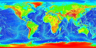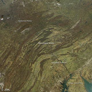
The geology of the Appalachians dates back to more than 480 million years ago. A look at rocks exposed in today's Appalachian Mountains reveals elongate belts of folded and thrust faulted marine sedimentary rocks, volcanic rocks and slivers of ancient ocean floor – strong evidence that these rocks were deformed during plate collision. The birth of the Appalachian ranges marks the first of several mountain building plate collisions that culminated in the construction of the supercontinent Pangaea with the Appalachians and neighboring Little Atlas near the center. These mountain ranges likely once reached elevations similar to those of the Alps and the Rocky Mountains before they were eroded.

The Los Angeles Basin is a sedimentary basin located in southern California, in a region known as the Peninsular Ranges. The basin is also connected to an anomalous group of east-west trending chains of mountains collectively known as the California Transverse Ranges. The present basin is a coastal lowland area, whose floor is marked by elongate low ridges and groups of hills that is located on the edge of the Pacific plate. The Los Angeles Basin, along with the Santa Barbara Channel, the Ventura Basin, the San Fernando Valley, and the San Gabriel Basin, lies within the greater southern California region. On the north, northeast, and east, the lowland basin is bound by the Santa Monica Mountains and Puente, Elysian, Repetto hills. To the southeast, the basin is bordered by the Santa Ana mountains and the San Joaquin Hills. The western boundary of the basin is marked by the Continental Borderland and is part of the onshore portion. The California borderland is characterized by north-west trending offshore ridges and basins. The Los Angeles Basin is notable for its great structural relief and complexity in relation to its geologic youth and small size for its prolific oil production. Yerkes et al. identify 5 major stages of the basin's evolution that begins in the Upper Cretaceous and ends in the Pleistocene. This basin can be classified as an irregular pull-apart basin accompanied by rotational tectonics during the post-early Miocene.

Oseberg is an offshore oil field with a gas cap in the North Sea located 140 km (87 mi) northwest of the city of Bergen on the southwestern coast of Norway. The field, which is 25 km long by 7 km wide, was discovered in 1979 and its development is known to be one of the significant milestones in emergence of Norway's independent oil and gas industry. The Oseberg field was named after Oseberg ship, one of Norway's most significant archeological discoveries. The ancient Viking ship from the early 9th century was discovered in a 1904 historical excavation of a burial mound at the Oseberg Farm, south of Oslo.
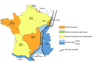
The Paris Basin is one of the major geological regions of France having developed since the Triassic on a basement formed by the Variscan orogeny. The sedimentary basin is a large sag in the craton, bordered by the Armorican Massif to the west, the Ardennes-Brabant axis to the north, the Massif des Vosges to the east, and the Massif Central to the south.
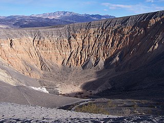
Ubehebe Crater is a large volcanic crater of the Ubehebe Craters volcanic field in the northern half of Death Valley, in Death Valley National Park, California, USA.

Heart Mountain is an 8,123-foot klippe just north of Cody in the U.S. state of Wyoming, rising from the floor of the Bighorn Basin. The mountain is composed of limestone and dolomite of Ordovician through Mississippian age, but it rests on the Willwood Formation, rocks that are about 55 million years old—rock on the summit of Heart Mountain is thus almost 300 million years older than the rocks at the base. For over one hundred years, geologists have tried to understand how these older rocks came to rest on much younger strata.

The Vargas tragedy was a natural disaster that occurred in Vargas State, Venezuela on 14–16 December 1999, when torrential rains caused flash floods and debris flows that killed tens of thousands of people, destroyed thousands of homes, and led to the complete collapse of the state's infrastructure. According to relief workers, the neighborhood of Los Corales was buried under 3 metres (9.8 ft) of mud and a high percentage of homes were simply swept into the ocean. Entire towns including Cerro Grande and Carmen de Uria completely disappeared. As much as 10% of the population of Vargas died during the event.

The Sarir Field was discovered in southern Cyrenaica during 1961 and is considered to be the largest oil field in Libya, with estimated oil reserves of 12 Gbbl (1.9 km3). Sarir is operated by the Arabian Gulf Oil Company (AGOCO), a subsidiary of the state-owned National Oil Corporation (NOC).

The McKittrick Oil Field is a large oil and gas field in western Kern County, California. The town of McKittrick overlies the northeastern portion of the oil field. Recognized as an oil field in the 19th century, but known by Native Americans for thousands of years due to its tar seeps, the field is ranked 19th in California by total ultimate oil recovery, and has had a cumulative production of over 303 million barrels (48,200,000 m3) of oil. The principal operators of the field as of 2008 were Chevron Corp. and Aera Energy LLC, but many independent oil exploration and production companies were also active on the field. The California Department of Oil, Gas and Geothermal Resources (DOGGR) estimates approximately 20 million recoverable barrels of oil remain in the ground.

The Charity Shoal crater is a 1.2–1.4 kilometers (0.75–0.87 mi) in diameter circular feature that lies submerged beneath the northeast end of Lake Ontario about 12 kilometers (7.5 mi) southwest of Wolfe Island, and 25 kilometers (16 mi) south of Kingston, Ontario at about latitude 44° 02′ N and longitude 76° 29′ W. It is hypothesized to be a Middle Ordovician impact crater.

The Corossol structure, which is also known as the Corossol crater, is a circular, 4.3-by-3.9-kilometer in diameter, underwater bedrock feature that is exposed on the gulf floor of the northwestern Gulf of Saint Lawrence 20-kilometer (12 mi) offshore of the city of Sept-Îles, Quebec in eastern Canada. It is hypothesized to be a possible pre-Pleistocene, extraterrestrial impact structure. It lies underwater at a depth of 40–208-meter (131–682 ft). This underwater feature was found during the study of high-resolution bathymetric and sub-bottom profiler data collected south of the city of Sept-Iles in the northwestern Gulf of Saint Lawrence.

The Deltana Platform lies offshore, on the platform of the Orinoco delta about 90 km northeast of the island Tobejuba in the state Delta Amacuro, and approximately 233 km southeast of Güiria, Sucre State, Venezuela.

The Columbus Basin is a foreland basin located off the south eastern coast of Trinidad within the East Venezuela Basin (EVB). Due to the intensive deformation occurring along the Caribbean and South American plates in this region, the basin has a unique structural and stratigraphic relationship. The Columbus Basin has been a prime area for hydrocarbon exploration and production as its structures, sediments and burial history provide ideal conditions for generation and storage of hydrocarbon reserves. The Columbus Basin serves as a depocenter for the Orinoco River delta, where it is infilled with 15 km of fluvio-deltaic sediment. The area has also been extensively deformed by series of north west to southeast normal faults and northeast to southwest trending anticline structures.

The Delta Field is located offshore from Nigeria on Oil Mining Leases (OML) 49 and 95. This is located within the Niger Delta Basin and sits in 12 feet of water. In 1965, the Delta 1 well was completed and the Delta Field opened in 1968 for production.

The Bolivar Coastal Fields (BCF), also known as the Bolivar Coastal Complex, is located on the eastern margin of Lake Maracaibo, Venezuela. Bolivar Coastal Field is the largest oil field in South America with its 6,000-7,000 wells and forest of related derricks, stretches thirty-five miles along the north-east coast of Lake Maracaibo. They form the largest oil field outside of the Middle East and contain mostly heavy oil with a gravity less than 22 degrees API. Also known as the Eastern Coast Fields, Bolivar Coastal Oil Field consists of Tía Juana, Lagunillas, Bachaquero, Ceuta, Motatán, Barua and Ambrosio. The Bolivar Coast field lies in the Maracaibo dry forests ecoregion, which has been severely damaged by farming and ranching as well as oil exploitation. The oil field still plays an important role in production from the nation with approximately 2.6 million barrels of oil a day. It is important to note that the oil and gas industry refers to the Bolivar Coastal Complex as a single oilfield, in spite of the fact that the oilfield consists of many sub-fields as stated above.
The geology of Brunei is primarily made up of Cenozoic rocks overlying deeper rock units on the island of Borneo. Rocks from the Oligocene through the Holocene are up to 15 kilometers thick.
The geology of Denmark includes 12 kilometers of unmetamorphosed sediments lie atop the Precambrian Fennoscandian Shield, the Norwegian-Scottish Caledonides and buried North German-Polish Caledonides. The stable Fennoscandian Shield formed from 1.45 billion years ago to 850 million years ago in the Proterozoic. The Fennoscandian Border Zone is a large fault, bounding the deep basement rock of the Danish Basin—a trough between the Border Zone and the Ringkobing-Fyn High. The Sorgenfrei-Tornquist Zone is a fault-bounded area displaying Cretaceous-Cenozoic inversion.
The geology of Saudi Arabia includes Precambrian igneous and metamorphic basement rocks exposed across much of the country. Thick sedimentary sequences from the Phanerozoic including sandstone, anhydrite, dolomite, limestone, chert and marl dominate much of the country's surface and host oil.