Portland, Newfoundland and Labrador

Last updated

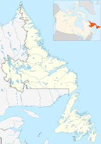
Canada Newfoundland and Labrador location map 2.svg
Red pog.svg
Portland

Portland is a settlement in Newfoundland and Labrador. It is part of the local service district of Lethbridge and Area.

Portland is located on Route 234, between Brooklyn and Jamestown, on the east side of Goose Bay, Bonavista Bay. Settled in the 1870s, it takes its name from a white rock, visible from the bay, making it look similar to Portland, England. The area was originally used for winter forestry work and for schooner building as well as some lobster fishing and agriculture. Very little fishing and farming is carried out today. A few people still log and own small sawmills.
Related Research Articles

<span class="mw-page-title-main">Ferryland (electoral district)</span> Provincial electoral district in Newfoundland and Labrador, Canada

Ferryland is a provincial electoral district for the House of Assembly of Newfoundland and Labrador, Canada. As of 2011, there are 8,571 eligible voters living within the district.

Hant's Harbour is an incorporated town located on the east side of Trinity Bay on the Bay de Verde Peninsula in the province of Newfoundland and Labrador, Canada. It has a population of 318 according to the 2021 Canadian census.

The community of Lethbridge is located 20 km (12 mi) from Clarenville, Newfoundland and Labrador along Route 230, on the Cabot Highway, to Bonavista. Route 233 and Route 234 also pass through the community. It is an unincorporated community with a population of 635 (2016). It is part of the local service district of Lethbridge and Area.

<span class="mw-page-title-main">Open Hall-Red Cliffe</span>

Open Hall-Red Cliffe is a local service district and designated place in the Canadian province of Newfoundland and Labrador.

Old Bonaventure is a small outport and harbour in the Trinity Bight area of Trinity Bay that was originally settled by English emigrants seeking a new life in the "New Founde Lande". It had a population of 85 in 1951 and 100 in 1956. Old Bonaventure's recently deepened natural harbour today serves as a point of delivery for a variety of off-shore fishing boats. "Old Bonaventure" was simply "Bonavenute" until the arrival of new settlers or "planters" led to the creation of New Bonaventure which absorbed the newcomers from England in the 19th century.

Fort Point, also known as Admiral's Point, is a point of land situated on the western shore to the entrance of Trinity Harbour, Trinity Bay, Newfoundland, Canada. The area was the site a fort which was located on the tip of the peninsula.

Dover is a small incorporated fishing and lumbering village located in a small cove at the head of Freshwater Bay, Bonavista Bay, Newfoundland, Canada. Settled in the early 1890s it was originally known as Shoal Bay, presumably from its many shallow coves and inlets in the area. From the 1950s to the 1970 Shoal Bay was referred to as Wellington , whereas the local residents called it Dover.

The Bonavista Peninsula is a large peninsula on the east coast of the island of Newfoundland in the Canadian province of Newfoundland and Labrador. It consists of 50 incorporated towns/unincorporated communities which have a population of 12,176 as of the 2016 Canadian Census. Bonavista is the largest population centre on the peninsula.

Musgrave Harbour is a town in the Canadian province of Newfoundland and Labrador.

Admirals Beach is a rural community located in Newfoundland and Labrador, Canada.

Indian Bay is located in Newfoundland, Canada.

Heart's Delight-Islington is a town on the south side of Trinity Bay in the Canadian province of Newfoundland and Labrador, located on Newfoundland and Labrador Route 80. The Post Office was established in 1954. The first Postmistress was Maggie Chislett.

Jamestown is a village located northeast of Clarenville, Newfoundland and Labrador, Canada.

Winter Brook is a settlement in Newfoundland and Labrador. It is part of the local service district of Lethbridge and Area.

Sweet Bay is a settlement in Newfoundland and Labrador. It is part of the local service district of Lethbridge and Area.

Morley's Siding is a settlement in Newfoundland and Labrador. It is part of the local service district of Lethbridge and Area.

Bay St. George South is a local service district and designated place in the Canadian province of Newfoundland and Labrador on the south coast of Bay St. George, a large bay on the west coast of the island of Newfoundland. Bay St. George South consists nine communities, namely Heatherton, Robinsons, Cartyville, McKay's, Jeffrey's, St. David's, St. Fintan's, Lock Leven en Highlands.

<span class="mw-page-title-main">Division No. 1, Subdivision G, Newfoundland and Labrador</span> Unorganized territory in Newfoundland and Labrador, Canada

Division No. 1, Subdivision G is an unorganized subdivision on the Avalon Peninsula in Newfoundland and Labrador, Canada. It is in Division 1 and contains the unincorporated communities of Baccalieu Island, Besom Cove, Bradley's Cove, Burnt Point, Caplin Cove, Daniel's Cove, Grates Cove, Gull Island, Job's Cove, Kingston, Long Beach, Lower Island Cove, Low Point, Northern Bay, Ochre Pit Cove, Red Head Cove, Riverhead, Smooth Cove and Western Bay.

Division No. 1, Subdivision L is an unorganized subdivision on the Avalon Peninsula in Newfoundland and Labrador, Canada. It is in Division 1 and contains the unincorporated communities of Bareneed, Black Duck Pond, Blow Me Down, Coley's Point South, Hibb's Cove, Pick Eyes, Port de Grave, Ship Cove and The Dock

<span class="mw-page-title-main">Lockesporte, Newfoundland and Labrador</span>

Lockesporte, also spelled Lockesport or Lockport and originally known as Lock's Harbour, was a fishing village and logging community on the eastern coast of Seal Bay, within the much larger Notre Dame Bay, Newfoundland, Canada.

References

  • Poole, Cyril; Cuff, Robert, eds. (1993). "Portland". Encyclopedia of Newfoundland and Labrador, volume 4. Memorial University of Newfoundland - Digital Archives Initiative: Harry Cuff Publications Ltd. pp. 403–404. Retrieved 15 February 2024. Encyclopedia of Newfoundland and Labrador

48°25′48″N53°49′08″W / 48.430°N 53.819°W / 48.430; -53.819