Related Research Articles

The Lesotho Highlands Water Project (LHWP) is an ongoing water supply project with a hydropower component, developed in partnership between the governments of Lesotho and South Africa. It comprises a system of several large dams and tunnels throughout Lesotho and delivers water to the Vaal River System in South Africa. In Lesotho, it involves the rivers Malibamatso, Matsoku, Senqunyane, and Senqu. It is Africa's largest water transfer scheme.

The Gariep Dam is located in South Africa, near the town of Norvalspont, bordering the Free State and Eastern Cape provinces. Its primary purpose is for irrigation, domestic and industrial use as well as for power generation. It the largest dam in South Africa.

The Kouga Dam is an arch dam on the Kouga River about 21 km (13 mi) west of Patensie in Kouga Local Municipality, South Africa. It supplies irrigation water to the Kouga and Gamtoos valleys as well as drinking water to the Port Elizabeth metropolitan area via the Loerie Balancing Dam. It was constructed between 1957 and 1969.

The Steenbras Dam, now referred to as Steenbras Lower Dam, is a gravity concrete arch type dam located in the Hottentots-Holland mountains, above Gordons Bay, near Cape Town in South Africa. It is one of the six large dams that make up the Western Cape Water Supply System. It is owned by the City of Cape Town and serves principally to supply water to that city. The dam wall is 28 metres (92 ft) high and 412 metres (1,352 ft) long; it impounds a reservoir of 36,133 megalitres over a surface area of 380 hectares when full.
Boskop Dam is an earth-fill type dam on the Mooi River, near Potchefstroom, North West Province, South Africa. It was constructed in 1959. The main purpose of the dam is for irrigation and domestic usage. Its hazard potential is ranked as high, due to poor maintenance and the development of sink holes.
Klipdrif Dam is an earth-fill type dam located on the Loopspruit and Enselspruit near Potchefstroom, North West, South Africa. The river flowing out the dam is the Loopspruit. It was established in 1990 and its primary purpose is to serve for irrigation. The hazard potential of the dam has been ranked significant (2).
Ncora Dam is a gravity type dam built by Concor and located on the Tsomo River, near Tsomo, Eastern Cape, South Africa. It was established in 1972 and serves mainly for irrigation purposes. The hazard potential of the dam has been ranked high (3).
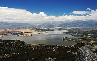
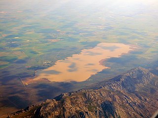
Theewaterskloof Dam is an earth-fill type dam located on the Sonderend River near Villiersdorp, Western Cape, South Africa. Administratively it is located within Theewaterskloof Local Municipality. It was established in 1978 and is the largest dam in the Western Cape Water Supply System with a capacity of 480 million cubic metres, about 41% of the water storage capacity available to Cape Town, which has a population of over 4 million people. The dam mainly serves for municipal and industrial use as well as for irrigation purposes. The hazard potential of the dam has been ranked high (3).
Voëlvlei Dam is a dam located in the Western Cape, South Africa near the town of Gouda. The earth-fill wall is 2,910 metres (9,550 ft) long and 10 metres (33 ft) high. The reservoir covers an area of 1,524 hectares and has a capacity of 168,000 megalitres, making it the second-largest reservoir in the Western Cape Water Supply System. Water from the reservoir is supplied to water treatment works of the City of Cape Town and the West Coast District Municipality, and can also be released into the Berg River for agricultural purposes or to fill the Misverstand Dam.

Wemmershoek Dam is a rock-fill type dam located on the Wemmershoek River near Franschhoek and Paarl in South Africa. It was constructed between 1953 and 1957 on behalf of the City of Cape Town. With a reservoir capacity of 58,644 megalitres, it provides approximately 6.5% of the storage capacity of the Western Cape Water Supply System which supplies Cape Town and surrounding areas.

Woodhead Dam is a dam on Table Mountain, Western Cape, South Africa. It was built in 1897 and supplies water to Cape Town. The dam, which was the first large masonry dam in South Africa, was designated as an International Historic Civil Engineering Landmark by the American Society of Civil Engineers in 2008.

The Crocodile River is a river in South Africa. At its confluence with the Marico River, the Limpopo River is formed.

Steenbras Upper Dam is an earth-fill type dam located in the Hottentots Holland Mountains above Gordons Bay in the Western Cape, South Africa. It impounds the Steenbras River upstream of the older Steenbras Dam. The dam was constructed in 1977 for the City of Cape Town and serves mainly for municipal and industrial use. The hazard potential of the dam has been ranked high (3).
The Vaal River Barrage Reservoir is a dam on the Vaal River near Vanderbijlpark, border Gauteng and Free State, South Africa.

Tlokwe Local Municipality was a local municipality in Dr Kenneth Kaunda District Municipality, North West Province, South Africa. The seat was Potchefstroom. After the municipal elections on 3 August 2016 it was merged into the larger JB Marks Local Municipality.
The Mooi River is a river in North West Province, South Africa. It is a tributary of the Vaal River and belongs to the Upper Vaal Water Management Area.
The De Hoop Dam is a gravity dam on the Steelpoort River, near Burgersfort, Limpopo, South Africa. Its purpose is to enable the extraction of rich mineral deposits in the eastern Limpopo province, and to supply water to towns, industries and communities in the Sekhukhune district, where service delivery was of a poor standard.
References
This article about a dam or floodgate in South Africa is a stub. You can help Wikipedia by expanding it. |