
A rock shelter is a shallow cave-like opening at the base of a bluff or cliff. In contrast to solutional caves (karst), which are often many miles long, rock shelters are almost always modest in size and extent.

A natural arch, natural bridge, or rock arch is a natural rock formation where an arch has formed with an opening underneath. Natural arches commonly form where inland cliffs, coastal cliffs, fins or stacks are subject to erosion from the sea, rivers or weathering.

A marsh is a wetland that is dominated by herbaceous rather than woody plant species. Marshes can often be found at the edges of lakes and streams, where they form a transition between the aquatic and terrestrial ecosystems. They are often dominated by grasses, rushes or reeds. If woody plants are present they tend to be low-growing shrubs, and then sometimes called carrs. This form of vegetation is what differentiates marshes from other types of wetland such as swamps, which are dominated by trees, and mires, which are wetlands that have accumulated deposits of acidic peat.
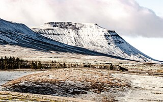
Ingleborough is the second-highest mountain in the Yorkshire Dales, England. It is one of the Yorkshire Three Peaks, and is frequently climbed as part of the Three Peaks walk.

Gaping Gill is a natural cave in North Yorkshire, England. It is one of the unmistakable landmarks on the southern slopes of Ingleborough – a 98-metre (322 ft) deep pothole with the stream Fell Beck flowing into it. After falling through one of the largest known underground chambers in Britain, the water disappears into the bouldery floor and eventually resurges adjacent to Ingleborough Cave.

In geology, a depression is a landform sunken or depressed below the surrounding area. Depressions form by various mechanisms.

Banning State Park is a state park of Minnesota, USA, stretched along 10 miles (16 km) of the Kettle River near Sandstone in Pine County. The centerpiece of the park is 1.5 miles (2.4 km) of churning rapids, some up to Class IV. The daring kayakers and canoeists who shoot Blueberry Slide, Mother's Delight, Dragon's Tooth, Little Banning, and Hell's Gate each spring attract spectators to the park. Landbound visitors can hike along the state's first Wild and Scenic River amid dramatic sandstone rock formations, large potholes carved by the river, and the remains of a historic quarry. Other features are Wolf Creek Falls and Robinson Ice Cave. The park is located directly off Interstate 35.

Wes Skiles Peacock Springs State Park is a 733-acre (297 ha) Florida State Park located on Peacock Springs Road, two miles (3 km) east of Luraville and on State Road 51, 16 miles (26 km) southwest of Live Oak, Florida. Activities include picnicking, swimming and diving, and wildlife viewing. Among the wildlife of the park are deer, bobcats, raccoon, squirrels, beaver and otters, as well as turkey, blue heron and barred owls. The park name commemorates the work of diver and explorer Wes Skiles. Prior to 2010 the park was known as Peacock Springs State Park. Amenities include a nature trail, six sinkholes, and Peacock and Bonnet Springs, with miles of underwater caves popular with cave divers. The two springs are tributaries of the Suwannee River. The park is open from 8:00 am till sundown year round.

A foiba — jama in South Slavic languages scientific and colloquial vocabulary — is a type of deep natural sinkhole, doline, or sink, and is a collapsed portion of bedrock above a void. Sinks may be a sheer vertical opening into a cave, or a shallow depression of many hectares. They are common in the Karst (Carso) region shared by Italy and Slovenia, as well as in a karst of Dinaric Alps in Bosnia and Herzegovina, Montenegro and Croatia.
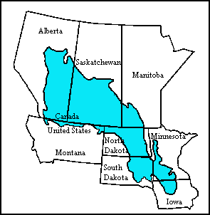
The Prairie Pothole Region (PPR) is an expansive area of the northern Great Plains that contains thousands of shallow wetlands known as potholes. These potholes are the result of glacier activity in the Wisconsin glaciation, which ended about 10,000 years ago. The decaying ice sheet left behind depressions formed by the uneven deposition of till in ground moraines. These depressions are called potholes, glacial potholes, kettles, or kettle lakes. They fill with water in the spring, creating wetlands, which range in duration from temporary to semi-permanent. The region covers an area of about 800,000 sq. km and expands across five U.S. states and three Canadian provinces. The hydrology of the wetlands is variable, which results in long term productivity and biodiversity. The PPR is a prime spot during breeding and nesting season for millions of migrating waterfowl.

Porth yr Ogof is a cave located near the village of Ystradfellte, near the southern boundary of the Brecon Beacons National Park in Wales. It lies on the course of the Afon Mellte, a river whose name translates as ‘lightning’, commonly explained as a reference to the flashy' nature of the river, i.e. rising and falling rapidly in response to rainfall. In 1998 the cave's passageways had been measured as over 2.25 kilometres (1.40 mi) in length. Among the cave's fifteen entrances is the largest cave entrance in Wales and one of the largest in the UK standing at nearly 20 metres (66 ft) wide and 8 metres (26 ft) high. The cave was used as a show cave many years ago, but it does not have the attractions of more decorated caves such as Dan yr Ogof, and so today the cave is more often used to introduce people to the enjoyment of the exploration of caves.

Groundwater recharge or deep drainage or deep percolation is a hydrologic process, where water moves downward from surface water to groundwater. Recharge is the primary method through which water enters an aquifer. This process usually occurs in the vadose zone below plant roots and, is often expressed as a flux to the water table surface. Groundwater recharge also encompasses water moving away from the water table farther into the saturated zone. Recharge occurs both naturally and through anthropogenic processes, where rainwater and or reclaimed water is routed to the subsurface.

A pit cave, shaft cave or vertical cave—or often simply called a pit or pot ; jama in South Slavic languages scientific and colloquial vocabulary —is a type of cave which contains one or more significant vertical shafts rather than being predominantly a conventional horizontal cave passage. Pit caves typically form in limestone as a result of long-term erosion by water. They can be open to the surface or found deep within horizontal caves. Among cavers, a pit is a vertical drop of any depth that cannot be negotiated safely without the use of ropes or ladders.
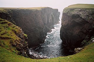
A geo or gio is an inlet, a gully or a narrow and deep cleft in the face of a cliff. Geos are common on the coastline of the Shetland and Orkney islands. They are created by the wave driven erosion of cliffs along faults and bedding planes in the rock. Geos may have sea caves at their heads. Such sea caves may collapse, extending the geo, or leaving depressions inland from the geo. Geos can also be created from this process.
Rod's Pot is a limestone cave above Burrington Combe in the Mendip Hills, in Somerset, England.

A panhole is a shallow depression or basin eroded into flat or gently sloping cohesive rock. Confusingly, some authors refer to panholes also as potholes, which is a term typically used for similarly shaped riverine landforms. Similar terms for this feature are gnamma (Australia), armchair hollows, weathering pans and solution pans.

In Earth science, a pothole is a smooth, bowl-shaped or cylindrical hollow, generally deeper than wide, found carved into the rocky bed of a watercourse. Other names used for riverine potholes are pot, (stream) kettle, giant's kettle, evorsion, hollow, rock mill, churn hole, eddy mill, and kolk. Although somewhat related to a pothole in origin, a plunge pool is the deep depression in a stream bed at the base of a waterfall. it is created by the erosional forces of turbulence generated by water falling on rocks at a waterfall's base where the water impacts. Potholes are also sometimes referred to as swirlholes. This word was created to avoid confusion with an English term for a vertical or steeply inclined karstic shaft in limestone. However, given widespread usage of this term for a type of fluvial sculpted bedrock landform, pothole is preferred in usage to swirlhole.

Portland Raised Beach refers to small raised beaches on each side of Portland Bill, on the Isle of Portland, part of the Jurassic Coast in Dorset, England. The main one is known as the West Pleistocene Raised Beach; nearby is the East Pleistocene Raised Beach.