The Yarra River or historically, the Yarra Yarra River, is a perennial river in south-central Victoria, Australia.

Flinders Street railway station is a train station located on the corner of Flinders and Swanston streets in Melbourne, Victoria, Australia. It is the busiest station in Victoria, serving the entire metropolitan rail network, 15 tram routes travelling to and from the city, and some country and regional V/Line services to eastern Victoria.

Princes Highway is a major road in Australia, extending from Sydney via Melbourne to Adelaide through the states of New South Wales, Victoria and South Australia. It has a length of 1,941 kilometres (1,206 mi) or 1,898 kilometres (1,179 mi) via the former alignments of the highway, although these routes are slower and connections to the bypassed sections of the original route are poor in many cases.

Port Melbourne is an inner-city suburb in Melbourne, Victoria, Australia, 3 km (2 mi) south-west of the Melbourne central business district, located within the Cities of Melbourne and Port Phillip local government areas. Port Melbourne recorded a population of 17,633 at the 2021 census.

Southbank is an inner-city suburb in Melbourne, Victoria, Australia, 1 km south of the Melbourne central business district, located within the Cities of Melbourne and Port Phillip local government areas. Southbank recorded a population of 22,631 at the 2021 census.

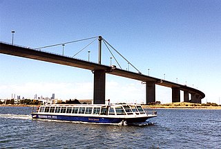
The West Gate Bridge is a steel, box girder, cable-stayed bridge in Melbourne, Victoria, Australia, spanning the Yarra River just north of its mouth into Port Phillip. It carries the West Gate Freeway and is a vital link between the Melbourne central business district (CBD) and western suburbs, with the industrial suburbs in the west, and with the city of Geelong 80 kilometres (50 mi) to the south-west. It is part of one of the busiest road corridors in Australia. The high span bridge was built to allow large cargo ships to access the docks in the Yarra River.

St Kilda Road is a street in Melbourne, Victoria, Australia. It is part of the locality of Melbourne which has the postcode of 3004, and along with Swanston Street forms a major spine of the city.

The West Gate Freeway is a major freeway in Melbourne, the busiest urban freeway and the busiest road in Australia, carrying upwards of 200,000 vehicles per day. It links Geelong and Melbourne's western suburbs to central Melbourne and beyond. It is also a link between Melbourne and the west and linking industrial and residential areas west of the Yarra River with the city and port areas. The West Gate Bridge is a part of the freeway.

The Monash Freeway is a major urban freeway in Victoria, Australia, linking Melbourne's CBD to its south-eastern suburbs and beyond to the Gippsland region. It carries up to 180,000 vehicles per day and is one of Australia's busiest freeways. The entire stretch of the Monash Freeway bears the designation M1.
South Eastern Freeway is a 73 km (45 mi) freeway in South Australia (SA). It is a part of the National Highway network linking the state capital cities of Adelaide, SA, and Melbourne, Victoria, and is signed as route M1. It carries traffic over the Adelaide Hills between Adelaide and the River Murray, near Murray Bridge, where it is connected via the Swanport Bridge to the Dukes Highway, which is the main road route to Victoria.

The Capital City Trail is a shared use path in Melbourne, Victoria, Australia, which circles the city centre and some inner eastern and northern suburbs. It is 29km in length, and mostly consists of sections of other trails, such as the Merri Creek Trail, Main Yarra Trail, Moonee Ponds Creek Trail and Inner Circle Rail Trail.

Orbost is a historic early settlers town in the Shire of East Gippsland, Victoria, 375 kilometres (233 mi) east of Melbourne and 235 kilometres (146 mi) south of Canberra where the Princes Highway crosses the Snowy River. It is about 16 kilometres (10 mi) from the surf and fishing seaside town of Marlo on the coast of Bass Strait and 217 km (135 mi) drive to Hotham Alpine Resort. Orbost is the service centre for the primary industries of beef, dairy cattle and sawmilling. More recently, tourism has become an important and thriving industry, being the major town close to several national parks that are between the east access to either the surf or the snow, including the famous Snowy River National Park, Alpine National Park, Errinundra National Park, Croajingolong National Park and Cape Conran Coastal Park.

The Alexandra Gardens are located on the south bank of the Yarra River, opposite Federation Square and the Melbourne Central Business District, in Victoria, Australia. The Gardens are bounded by the Yarra River to the north, Princes and Swan street bridges, with Queen Victoria Gardens and Kings Domain across Alexandra Avenue to the south. The gardens are part of the Domain parklands which stretch to the Royal Botanic Gardens and were first laid out in 1901, under the direction of Carlo Catani, Chief Engineer of the Public Works Department. The Alexandra Gardens were named in honour of Alexandra of Denmark, in the year her reign as Queen Consort of the United Kingdom and the British Dominions and Empress consort of India began. The Alexandra Gardens are listed on the Victorian Heritage Register due to their historical and archaeological significance.

The Geelong Ring Road is a freeway ring road in Australia beside Geelong's western suburbs from the Princes Freeway at Corio to the Princes Highway at Waurn Ponds. It also connects to the Midland Highway towards Ballarat, and the Hamilton Highway.

Princes Bridge, originally Prince's Bridge, is a bridge in central Melbourne, Australia that spans the Yarra River. It is built on the site of one of the oldest river crossings in the city, and forms a gateway into the central city from the south. The bridge connects Swanston Street on the north bank of the Yarra River to St Kilda Road on the south bank, and carries road, tram and pedestrian traffic. The present bridge was built in 1888 and is listed on the Victorian Heritage Register.

The South Coast refers to the narrow coastal belt from the Shoalhaven district in the north to the state border with Victoria in the south in the south-eastern part of the State of New South Wales, Australia. It is bordered to the west by the coastal escarpment of the Southern Tablelands, and is largely covered by a series of national parks, namely Jervis Bay National Park, Eurobodalla National Park, and Beowa National Park. To the east is the coastline of the Pacific Ocean, which is characterised by rolling farmlands, small towns and villages along a rocky coastline, interspersed by numerous beaches and lakes.

Jolimont Yard was an array of railway lines and carriage sidings on the edge of the central business district of Melbourne, Australia. Located between Flinders Street station, Richmond Junction, the Yarra River and Flinders Street they were often criticised for cutting off the city from the river, being the site of many redevelopment proposals. The Princes Gate Towers were built over part of the yard in the 1960s, which themselves were replaced by Federation Square in the 2000s. The rail sidings themselves were progressively removed from the 1980s to the 1990s with only running lines today, but the area continues to be referred to as the 'Jolimont railyards' by Melburnians.


