
Bristol Harbour is the harbour in the city of Bristol, England. The harbour covers an area of 70 acres. It is the former natural tidal river Avon through the city but was made into its current form in 1809 when the tide was prevented from going out permanently. A tidal by-pass was dug for 2 miles through the fields of Bedminster for the river, known as the "River Avon New Cut", "New Cut", or simply "The Cut". It is often called the Floating Harbour as the water level remains constant and it is not affected by the state of the tide on the river in the Avon Gorge, The New Cut or the natural river southeast of Temple Meads to its source.

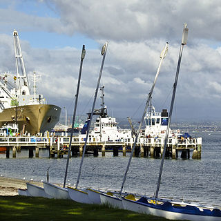
Waitematā Harbour is the main access by sea to Auckland, New Zealand. For this reason it is often referred to as Auckland Harbour, despite the fact that it is one of two harbours adjoining the city. The harbour forms the northern and eastern coasts of the Auckland isthmus and is crossed by the Auckland Harbour Bridge. It is matched on the southern side of the city by the shallower waters of the Manukau Harbour.

The Bristol Industrial Museum was a museum in Bristol, England, located on Prince's Wharf beside the Floating Harbour and which closed in 2006. On display were items from Bristol's industrial past – including aviation, car and bus manufacture, and printing – and exhibits documenting Bristol's maritime history. The museum was managed by Bristol City Council along with nearby preserved industrial relics along Prince's Wharf, including the Bristol Harbour Railway, cranes and a small fleet of preserved vessels. The railway, cranes and vessels all now form part of the working exhibits at M Shed Museum.

The Bristol Harbour Railway was a standard-gauge industrial railway that served the wharves and docks of Bristol, England. The line, which had a network of approximately 5 mi (8.0 km) of track, connected the Floating Harbour to the GWR mainline at Bristol Temple Meads. Freight could be transported directly by waggons to Paddington Station in London. The railway officially closed in 1964.

Spike Island is an inner city and harbour area of the English port city of Bristol, adjoining the city centre. It comprises the strip of land between the Floating Harbour to the north and the tidal New Cut of the River Avon to the south, from the dock entrance to the west to Bathurst Basin in the east. The island forms part of Cabot ward. The area between the Docks and New cut to the east of Bathurst Basin is in the neighbourhoods of Redcliffe and St Philip's Marsh.

Viaduct Harbour, formerly known as Viaduct Basin, is a former commercial harbour on the Auckland waterfront that has been turned into a development of mostly upscale apartments, office space and restaurants. It is located on the site of a formerly run-down area of the Freemans Bay / Auckland CBD waterfront in Auckland, New Zealand. As a centre of activity of the 2000 America's Cup hosted by the Royal New Zealand Yacht Squadron, as well as the 2022 Rally New Zealand, the precinct enjoyed considerable popularity with locals and foreign visitors.
The Onerahi Branch, sometimes known as the Grahamstown Railway, was a branch line railway in the Northland Region of New Zealand. It operated from 1911 until 1933 and linked the city of Whangārei to the nearby harbour in Onerahi.

The Onehunga Branch railway line is a section of the Onehunga Line in Auckland, New Zealand. It was constructed by the Auckland Provincial Government and opened from Penrose to Onehunga on 24 December 1873, and extended to Onehunga Wharf on 28 November 1878. It is 3.6 kilometres (2.2 mi) in length and is single-track only.

Bristol Bridge is a bridge over the floating harbour in Bristol, England. The floating harbour was constructed on the original course of the River Avon, and there has been a bridge on the site since long before the harbour was created by impounding the river in 1809. The current bridge was completed in 1768 and is a Grade II listed building.

Princes Wharf is a former commercial wharf on the Auckland waterfront, in Auckland, New Zealand, which has been redeveloped into a multi-story high-class mixed-use development and cruise ship terminal.

Ports of Auckland Limited (POAL), the successor to the Auckland Harbour Board, is the Auckland Council-owned company administering Auckland's commercial freight and cruise ship harbour facilities. As the company operates all of the associated facilities in the Greater Auckland area, this article is about both the current company and the ports of Auckland themselves.

Netham Lock is the point at Netham in Bristol at which boats from the River Avon, acting as part of the Kennet and Avon Canal, gain access to Bristol's Floating Harbour.

The Auckland waterfront is a city-side stretch of the southern Waitematā Harbour coastline in Auckland, New Zealand. Previously mostly dominated by Ports of Auckland uses, from the 2000s on it is becoming increasingly open to recreational public use, with a number of former wharves being converted to office, entertainment, and later also some residential uses.
The Port of Tauranga is situated in Tauranga, New Zealand. It is the largest port in the country both in terms of total cargo volume, and in terms of container throughput with container volumes exceeding 1.2 million TEUs. The port is operated by Port of Tauranga Ltd. This article is about both the company and the port itself.
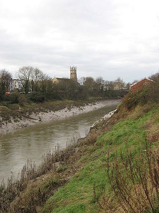
The New Cut is an artificial waterway which was constructed between 1804 and 1809 to divert the tidal river Avon through south and east Bristol, England. This was part of the process of constructing Bristol's Floating Harbour, under the supervision of engineer William Jessop. The cut runs from Totterdown Basin at the eastern end of St Phillip's Marsh, near Temple Meads, to the Underfall sluices at Rownham in Hotwells and rejoining the original course of the tidal Avon.
Queens Wharf is a concrete wharf in Auckland, New Zealand, that continues off Queen Street. It was previously owned and used by Ports of Auckland. In 2010 it was sold to the Auckland Regional Council and the New Zealand Government, and it was transformed to act as "Party Central" for the 2011 Rugby World Cup.

The Bristol Feeder Canal is a body of water in Bristol, England, that connects the Floating Harbour with the River Avon.
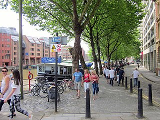
Quay Street is the northernmost street in the Auckland CBD. The Auckland Ferry Terminal, which has ferries running to Devonport, Waiheke Island, and other places in Waitematā Harbour; the Hilton Auckland hotel; and Ports of Auckland are on the north side of the street. The Britomart Transport Centre, Queen Elizabeth Square and Grand Mercure Auckland hotel are on the south side.

SS Hilonian was a general passenger and cargo steamer, built as the Triumph in 1880 at Middlesbrough for McIntyre & Co, and later fitted with refrigeration equipment and leased to Shaw Savill and the New Zealand Shipping Company. She sank and ran aground many times, the final sinking being by torpedo in 1917.
Welsh Back is a wharf and street alongside the floating harbour in the centre of the city of Bristol, England. The wharf and street extend some 450 metres (1,480 ft) along the west side of the harbour between Bristol Bridge and Redcliffe Bridge. At the northern end, the street and wharf are immediately adjacent, but to the south they are separated by a range of single story transit sheds. The wharf is a grade II listed structure and takes its name because it was freqented by vessels from Welsh ports.