
This is a list of the lists of islands in the world grouped by country, by continent, by body of water, and by other classifications. For rank-order lists, see the other lists of islands below.
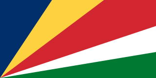
Seychelles, officially the Republic of Seychelles, is an archipelagic island country in the Indian Ocean at the eastern edge of the Somali Sea. It consists of 115 islands. Its capital and largest city, Victoria, is 1,500 kilometres (932 mi) east of mainland Africa. Other nearby island countries and territories include the Comoros, Madagascar, Mauritius, and the French overseas regions of Mayotte and Réunion to the south; and Maldives and the Chagos Archipelago to the east. It is the least populous sovereign African country, with an estimated 2020 population of 98,462.

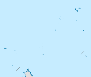
Seychelles is a small island country located in the Somali sea northeast of Madagascar and about 835 mi (1,344 km) from Mogadishu, Somalia, its nearest foreign mainland city, while Antsiranana is the nearest foreign city overall. Seychelles lies between approximately 4ºS and 10ºS and 46ºE and 54ºE. The nation is an archipelago of 115 tropical islands, some granite and some coral. the majority of which are small and uninhabited. The landmass is only 452 km2 (175 sq mi), but the islands are spread wide over an exclusive economic zone of 1,336,559 km2 (516,048 sq mi). About 90 percent of the population of 90,000 live on Mahé, 9 percent on Praslin and La Digue. Around a third of the land area is the island of Mahé and a further third the atoll of Aldabra.
Providence often refers to:
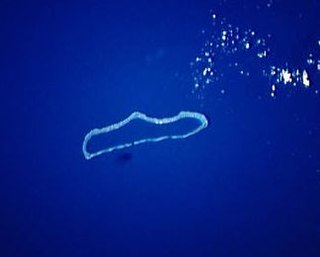
Aldabra is the world's second-largest coral atoll. It is situated in the Aldabra Group of islands in the Indian Ocean that are part of the Outer Islands of the Seychelles, with a distance of 1,120 km (700 mi) southwest of the capital, Victoria, on Mahé Island.
Caribbean English dialects of the English language are spoken in the Caribbean and Liberia, most countries on the Caribbean coast of Central America, and Guyana and Suriname on the coast of South America. Caribbean English is influenced by but is different from the English-based Creole varieties spoken in the region. In the Caribbean, there is a great deal of variation in how English is spoken. Scholars generally agree that although the dialects themselves vary significantly in each country, they primarily have roots in British English and West African languages. Caribbean English in countries with a plurality Indian population, such as Trinidad and Tobago and Guyana, has been influenced by Hindustani and other South Asian languages, in addition to British English and West African languages.
The following are the regional bird lists by continent.

The Archipelago of San Andrés, Providencia and Santa Catalina, or, in everyday language, San Andrés and Providencia, is one of the departments of Colombia, and the only one in North America. It consists of two island groups in the Caribbean Sea about 775 km (482 mi) northwest of mainland Colombia, and eight outlying banks and reefs. The largest island of the archipelago is called San Andrés and its capital is San Andrés. The other large islands are Providencia and Santa Catalina Islands which lie to the north-east of San Andrés; their capital is Santa Isabel.

Bajo Nuevo Bank, also known as the Petrel Islands, is a small, uninhabited reef with some small grass-covered islets, located in the western Caribbean Sea at 15°53′N78°38′W, with a lighthouse on Low Cay at 15°51′N78°38′W. The closest neighbouring land feature is Serranilla Bank, located 110 kilometres to the west.
Cosmoledo Atoll is an atoll of the Aldabra Group and belongs to the Outer Islands of the Seychelles, and is located 1,029 km (639 mi) southwest of the capital, Victoria, on Mahé Island.
The Farquhar Atoll is part of the Farquhar Group of islands in the Seychelles that are part of the Outer Islands. It is located 770 kilometres southwest of the capital, Victoria, on Mahé Island.

The Farquhar Group belong to the Outer Islands of the Seychelles, lying in the southwest of the island nation, more than 700 km (430 mi) southwest of the capital, Victoria, on Mahé Island.
The Providence Atoll is part of the Farquhar Group of islands in the Seychelles that are part of the Outer Islands, with a distance of 705 km (438 mi) southwest of the capital, Victoria, on Mahé Island.
Ujelang Atoll is a coral atoll of 30 islands in the Pacific Ocean, in the Ralik Chain of the Marshall Islands. Its total land area is 1.86 square kilometres (0.72 sq mi), and it encloses a lagoon of 185.94 square kilometres (71.79 sq mi). It is the westernmost island in the Marshall Islands, approximately 217 kilometres (135 mi) southeast of Enewetak, and approximately 600 kilometres (370 mi) west of the main Ralik Chain.

Isla de Providencia, historically Old Providence, and generally known as Providencia, is a mountainous Caribbean island that is part of the Colombian department of Archipelago of San Andrés, Providencia and Santa Catalina and the municipality of Providencia and Santa Catalina Islands, lying midway between Costa Rica and Jamaica. Providencia's maximum elevation is 360 metres (1,180 ft) above sea level. The smaller Santa Catalina Island to the northwest is connected by a 100 metres (330 ft) footbridge to its larger sister Providencia Island. Providencia Island has an area of 17 square kilometers; the two islands cover an area of 22 square kilometres (8.5 sq mi) and form the municipality of Santa Isabel, which had a population of 4,927 at the Census of 2005. The island is served by El Embrujo Airport, which the Colombian Government plans to expand in order to take international flights.
Cerf or CERF may refer to:
The Outer Islands or Coralline Seychelles (archipelago) is a collective term for those islands of the Seychelles that are not on the shallow Seychelles Bank which defines the location of the granitic Inner Islands archipelago to the east. The local Seychellois Creole name for the outer islands is Zil Elwannyen Sesel, while the French name is Îles Eloignées. They are all of coral formation, and in the western Indian Ocean.
St. Pierre Island is a raised reef island west of Providence Atoll and part of Farquhar Group, which belongs to the Outer Islands of the Seychelles. It has a distance of 736 km (457 mi) southwest of the capital, Victoria, on Mahé Island.

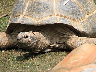
The Wildlife of Seychelles comprises the flora and fauna of the Seychelles islands off the eastern coast of Africa in the western Indian Ocean.

Intense Tropical Cyclone Bondo was the first of a series of six tropical cyclones to impact Madagascar during the 2006–07 South-West Indian Ocean cyclone season. Bondo developed on December 15 in the central Indian Ocean, west of Diego Garcia. After strengthening into a moderate tropical storm on December 18, the storm rapidly intensified while moving westward, taking advantage of favorable atmospheric conditions. Within 18 hours of being named, Bondo intensified to tropical cyclone status, or the equivalent of a minimal hurricane. The Météo-France office on Réunion (MFR) estimated peak 10 minute sustained winds of 205 km/h (125 mph), although the American-based Joint Typhoon Warning Center estimated stronger 1 minute winds of 250 km/h (155 mph). While near peak intensity, Bondo passed just south of Agaléga island, before weakening slightly and moving through the Farquhar Group of islands belonging to the Seychelles, becoming the strongest cyclone to affect that island group in decades. Bondo turned southwestward, and after brushing the northern coast of Madagascar, the cyclone made landfall near Mahajanga on December 25. The storm continued southward, and was last tracked by the MFR on December 28.