
Alberta is one of the thirteen provinces and territories of Canada. It is part of Western Canada and is one of the three prairie provinces. Alberta is bordered by British Columbia to the west, Saskatchewan to the east, the Northwest Territories (NWT) to the north, and the U.S. state of Montana to the south. It is one of the only two landlocked provinces in Canada. The eastern part of the province is occupied by the Great Plains, while the western part borders the Rocky Mountains. The province has a predominantly continental climate but experiences quick temperature changes due to air aridity. Seasonal temperature swings are less pronounced in western Alberta due to occasional Chinook winds.

Grande Prairie is a city in northwest Alberta, Canada within the southern portion of an area known as Peace River Country. It is located at the intersection of Highway 43 and Highway 40, approximately 456 km (283 mi) northwest of Edmonton. The city is surrounded by the County of Grande Prairie No. 1.
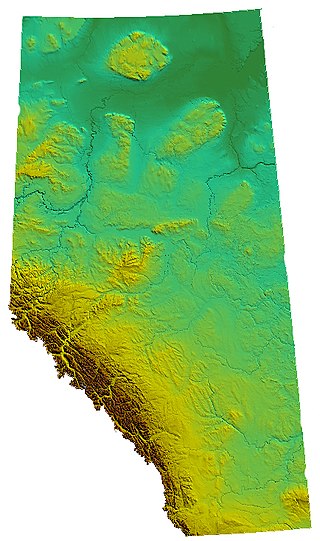
Alberta is one of the thirteen provinces and territories of Canada. Located in Western Canada, the province has an area of 661,190 km2 (255,290 sq mi) and is bounded to the south by the United States state of Montana along 49° north for 298 km (185 mi); to the east at 110° west by the province of Saskatchewan for 1,223 km (760 mi); and at 60° north the Northwest Territories for 644 km (400 mi). The southern half of the province borders British Columbia along the Continental Divide of the Americas on the peaks of the Rocky Mountains, while the northern half borders British Columbia along the 120th meridian west. Along with Saskatchewan it is one of only two landlocked provinces or territories.

Peace River is a provincial electoral district in Alberta, Canada. The district is mandated to return a single member to the Legislative Assembly of Alberta using the first past the post method of voting. The district used instant-runoff voting from 1926 to 1957.
Alberta Provincial Highway No. 2, commonly referred to as Highway 2 or the Queen Elizabeth II Highway, is a major highway in Alberta that stretches from the Canada–United States border through Calgary and Edmonton to Grande Prairie. Running primarily north to south for approximately 1,273 kilometres (791 mi), it is the longest and busiest highway in the province carrying more than 170,000 vehicles per day near Downtown Calgary. The Fort Macleod—Edmonton section forms a portion of the CANAMEX Corridor that links Alaska to Mexico. More than half of Alberta's 4 million residents live in the Calgary–Edmonton Corridor created by Highway 2.
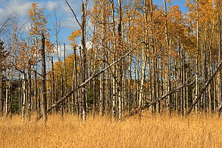
Aspen parkland refers to a very large area of transitional biome between prairie and boreal forest in two sections, namely the Peace River Country of northwestern Alberta crossing the border into British Columbia, and a much larger area stretching from central Alberta, all across central Saskatchewan to south central Manitoba and continuing into small parts of the US states of Minnesota and North Dakota. Aspen parkland consists of groves of aspen, poplar and spruce, interspersed with areas of prairie grasslands, also intersected by large stream and river valleys lined with aspen-spruce forests and dense shrubbery. This is the largest boreal-grassland transition zone in the world and is a zone of constant competition and tension as prairie and woodlands struggle to overtake each other within the parkland.

The Peace River Regional District is a regional district in northeastern British Columbia, Canada. The regional district comprises seven municipalities and four electoral areas. Its member municipalities are the cities of Fort St. John and Dawson Creek, the district municipalities of Tumbler Ridge, Chetwynd, Taylor, and Hudson's Hope, and the village of Pouce Coupe. The district's administrative offices are in Dawson Creek.

The Peace River Country is an aspen parkland region centring on the Peace River in Canada. It extends from northwestern Alberta to the Rocky Mountains in northeastern British Columbia, where a certain portion of the region is also referred to as the Peace River Block.

The Court of King's Bench of Alberta is the superior trial court of the Canadian province of Alberta. During the reign of Elizabeth II, it was named Court of Queen's Bench of Alberta.
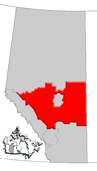
Central Alberta is a region located in the Canadian province of Alberta.

Northern Alberta is a geographic region located in the Canadian province of Alberta.
Grovedale is a hamlet in northern Alberta, Canada within the Municipal District of Greenview No. 16. It is located on Highway 666 south of Grande Prairie. It is just south of the Wapiti River valley, amidst farmland and ranchland at the northern limits of the boreal forests and aspen parkland in the foothills of the Canadian Rockies.
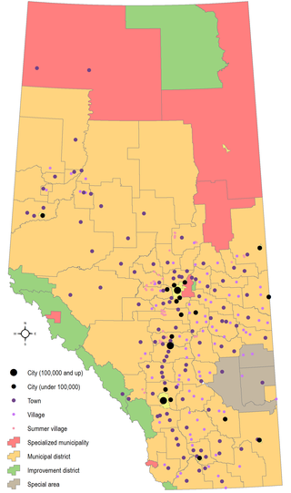
Municipal elections were held in Alberta, Canada on Monday, October 15, 2007. Since 1968, provincial legislation has required every municipality to hold triennial elections. Mayors (reeves), councillors (aldermen), and trustees were elected to office in 15 of the 16 cities, all 111 towns, all 99 villages, all 4 specialized municipalities, all 64 municipal districts, 3 of the 7 improvement districts, and the advisory councils of the 3 special areas. The City of Lloydminster is on the Saskatchewan schedule, and held elections on October 25, 2006 and October 28, 2009, while 4 improvement districts have no councils and are led solely by the Minister of Municipal Affairs. Since the 2004 municipal elections, the Town of Lac La Biche and Lakeland County amalgamated to form Lac La Biche County, the villages of Irricana and Onoway became towns, the Town of Brooks became a city, and the Village of Sangudo was dissolved.

Janice Sarich was a Canadian provincial-level politician. She served as member of the Legislative Assembly of Alberta (MLA) from 2008 until 2015, representing the electoral constituency of Edmonton-Decore and sitting as a Progressive Conservative.
Alberta Health Services (AHS) is the single health authority for the Canadian province of Alberta and the "largest integrated provincial health care system" in Canada. Headquartered in Edmonton, AHS delivers medical care on behalf of the Government of Alberta's Ministry of Health. It operates 850 facilities throughout the province, including hospitals, clinics, continuing care facilities, mental health facilities and community health sites, that provide a variety of programs and services. AHS is the largest employer in the province of Alberta. In 2019, AHS served 4.3 million Albertans with a staff of 125,000 staff and 10,000 physicians, and an annual budget of $15.365 billion. Mauro Chies is the interim President and CEO of AHS and reports to Dr. John Cowell, the AHS Official Administrator. The Official Administrator is accountable to the Minister of Health and the Premier.

Municipal elections were held in Alberta, Canada on Monday, October 18, 2010. Since 1968, provincial legislation has required every municipality to hold triennial elections. Mayors (reeves), councillors (aldermen), and trustees were elected to office in 16 of the 17 cities, all 108 towns, all 95 villages, all 5 specialized municipalities, all 64 municipal districts, 3 of the 7 improvement districts, and the advisory councils of the 3 special areas. The City of Lloydminster is on the Saskatchewan schedule, and held elections on October 28, 2009 and October 24, 2012, while 4 improvement districts have no councils and are led solely by the Minister of Municipal Affairs. Since the 2007 municipal elections, the villages of Derwent, Kinuso, New Sarepta, and Thorhild were dissolved, the Municipality of Crowsnest Pass changed from town to specialized municipality status, and the Town of Lacombe became a city.
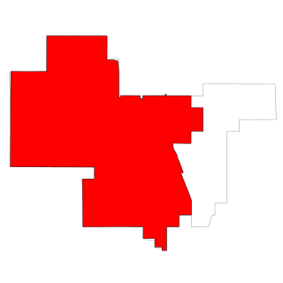
Grande Prairie is a provincial electoral district in Alberta, Canada, that has existed twice, first from 1930 to 1993 and again from 2019. It is one of 87 districts mandated to return a single member (MLA) to the Legislative Assembly of Alberta.
Grande Prairie Public School District (GPPSD) is a school division in Grande Prairie, Alberta, Canada since 1911. The GPPSD is responsible for delivering the Alberta provincial curriculum, as directed by the provincial ministry of education, Alberta Education, to over 8,400 students (preschool to grade 12) in eighteen schools. The division provides preschool, French immersion, Montessori, Christian education, sports-focused, and International Baccalaureate programs.

The following outline is provided as an overview of and topical guide to Alberta:

Travis Toews is a Canadian politician elected in the 2019 Alberta general election to represent the electoral district of Grande Prairie-Wapiti in the 30th Alberta Legislature. He was appointed as Minister of Finance of Alberta and President of the Treasury Board on April 30, 2019, by Alberta Premier Jason Kenney.


