Trongsa, previously Tongsa, is a Thromde or town, and the capital of Trongsa District in central Bhutan. The name means "new village" in Dzongkha. The first temple was built in 1543 by the Drukpa lama Ngagi Wangchuck, who was the great-grandfather of Ngawang Namgyal, Zhabdrung Rinpoche, the unifier of Bhutan.
Geilo is a centre in the municipality of Hol in Viken county, Norway. Geilo is primarily a ski resort town, with around 2,500 inhabitants. It is situated in the valley of Hallingdal, 250 km from Oslo and 260 km from Bergen. The Bergen Line facilitated Geilo's development as the first skiing resort in the country, and it is still one of the largest. It is also known for having some of the most luxurious and expensive holiday cabins in Norway. The center of the town lies at 800 meters above sea level, and its highest point is 1178 meters above sea level.

Brahmagiri, is a mountain range in the Western Ghats of south India. It is situated on the border between Kodagu district in Karnataka state in the north and Wayanad district of Kerala state on the south. Brahmagiri Hill, at 1608 m height, is a scenic tourist attraction. The top of Brahmagiri Hill is well forested and has much wildlife.

Vavuniya is a city of Vavuniya District in the Northern Province of Sri Lanka. The municipality is administered by an Municipal Council. The town has been known since ancient times, but being a heavily forested area, less than 100,000 people lived in the entire district before the Sri Lankan Civil War. The city is situated as a border town that divides the Tamil and Sinhalese population. To the south of the city are the Sinhala cities and to the north are the Tamil cities. The city has a large population of Tamils, Muslims and a significant number of Sinhalese. In the early days, Vavuniya was known as Vanni due to the abundance of Vanni Trees. The Security Forces Headquarters - Wanni is located in Vavuniya.

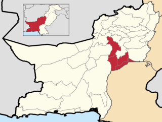
Nasirabad Division is an administrative division of Balochistan Province, Pakistan. It is the only Irrigation & Agricultural Division of Balochistan, The division connects Balochistan with Sindh. Nasirabad division created by bifurcation of Sibi division in 1987. Its Divisional headquarters are at Dera Murad Jamali.

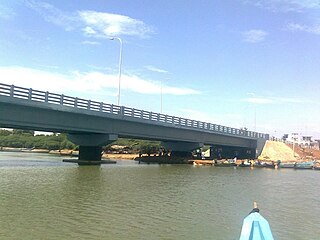
Ponneri is a town located in Chennai Metropolitan Area, Thiruvallur district in the Indian state of Tamil Nadu. It is located in Ponneri taluk. Ponneri is major destination for Andhra Pradesh people to buy goods. It is a part of the area Chennai Metropolitan Development Authority (CMDA) and a vital locality in Chennai Metropolitan Area.
The A9 Highway is a 321-kilometer-long (199 mi) highway in Sri Lanka, which connects the central city of Kandy with Jaffna, a city on the northern tip of the island.
Operation Jayasikurui, was a Sri Lankan military operation launched on 13 May 1997, it lasted until 1999, when it was called off. The operation was initially launched for 6 months but cancelled after 18 months as Sri Lankan government faced huge loss. It was the largest military operation undertaken by the armed forces at the time.
Maankulam or Mankulam is located in northern Sri Lanka, about 1.5 hours drive south of City of Jaffna.
Nedunkerny is a town in Vavuniya District, Sri Lanka. The roads going through Nedunkerny link Puliyankulam with Oddusuddan, and Puliyankulam with Mullaitivu.

Parangi Aru is a river in Northern Province, Sri Lanka. The river rises in central Vavuniya District, before flowing north/north-west through Vavuniya District, Mannar District and Mullaitivu District. The river empties into Palk Bay.
The A 29 road is an A-Grade trunk road in Sri Lanka. It connects Horowapothana with Vavuniya.
The A 30 road is an A-Grade trunk road in Sri Lanka. It connects Vavuniya with Parayanalankulam.

The northern line is a railway line in Sri Lanka. Branching off the Main Line at Polgahawela Junction the line heads north through North Western, North Central and Northern provinces before terminating at the northern port of Kankesanthurai. The line is 339 kilometres (211 mi) long and has 55 stations between Polgahawela Junction and Vavuniya. It is the longest railway line in Sri Lanka. The line opened in 1894. Major cities served by the line include Kurunegala, Anuradhapura, Vavuniya and Jaffna. The popular Yal Devi service operates on the line. The line was severely affected by the civil war and no services operated north of Vavuniya after 1990. Reconstruction of this section of the line commenced following the end of the civil war in 2009 and was fully completed in early 2015.

Anuradhapura Railway Station is a railway station in Anuradhapura, Sri Lanka. The station is served by Sri Lanka Railways, with Northern Line services, such as the Yal Devi, calling at the station.
The Vanni forest is a heavy forest which covers the Vanni area and the majority of the Northern Province of Sri Lanka. This jungle is spread from Omanthai in south to Paranthan in north. This jungle played a very significant role in the history of Sri Lanka. This forest is located in a dry-zone area. The biodiversity in the Vanni forest is considerably low. There are approximately 300,000 people living near the forest area.
National Highway 87 is a National Highway in southern India. It crosses the Pamban Bridge before entering into Pamban Island. The total length runs up to 154 km (96 mi). The 5 km road between Mukundarayar Chathiram and Dhanuskodi was destroyed during the 1964 cyclone. Then the Government of India has started construction of the new stretch of road on 2015 and opened to vehicles with some restrictions on Feb'2017 at a cost of ₹ 250 million. At the same time, the road between Madurai and Rameswaram was converted from a two lane road to a four-lane highway. Then Union minister for road transport and shipping Shri.Nitin Gadkari laid the foundation stone for the Rs 1,387-crore project in Madurai on 17 July 2015. An initial outlay of Rs 927 crore was made {May 2019} and the project has been sanctioned for Rs 1,387 crore. Then the first 75km stretch from Madurai to Paramakudi was proposed to be converted into a proper four-lane road which is a Green Highway, while the remaining 39km stretch from Paramakudi to Ramanathapuram was widened as a two-lane road with paved shoulders. This road includes bypass from Madurai to Manalur which is a newly constructed route skipping the old route(which runs through Puliyankulam and Silaiman), and has bypasses at several places like Thiruppuvanam, Thiruppachethi, Rajagambiram, Paramakudi and Ramanathapuram which would substantially ease traffic congestion in these towns and also saves time for those tourists who are going to Rameswaram. Falling under the Old NH-49, this project is one of the largest completed green corridor in Tamil Nadu by the National Highways Authority of India in the recent times.
The Battle of Kanakarayankulam was fought on 4 December 1997, during the Sri Lankan civil war between the Sri Lanka Armed Forces and the Liberation Tigers of Tamil Eelam (LTTE). It is known as the "worst-ever commando debacle" in Sri Lankan military history.


