Myanmar
- Putao District, a district of Kachin State
- Putao Township, in Putao District
- Putao, Myanmar, the capital of Putao District, Kachin State
Putao may refer to:

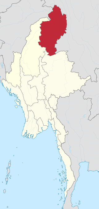
Kachin State is the northernmost state of Myanmar. It is bordered by China to the north and east, Shan State to the south, and Sagaing Region and India to the west. It lies between north latitude 23° 27' and 28° 25' longitude 96° 0' and 98° 44'. The area of Kachin State is 89,041 km2 (34,379 sq mi). The capital of the state is Myitkyina. Other important towns include Bhamo, Mohnyin and Putao.

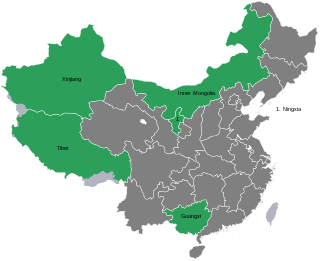
Chinese autonomous administrative divisions are associated with one or more ethnic minorities that are designated as autonomous within the People's Republic of China. These areas are recognized in the Constitution of the People's Republic of China and are nominally given a number of rights not accorded to other administrative divisions of China. For example, Tibetan minorities in autonomous regions are granted rights and support not given to the Han Chinese, such as fiscal and medical subsidies.

The autonomous regions are one of four types of province-level divisions of China. Like Chinese provinces, an autonomous region has its own local government, but under the law of the People's Republic of China, an autonomous region has more legislative rights, such as the right to "formulate self-government regulations and other separate regulations." An autonomous region is the highest level of minority autonomous entity in China, which has a comparably higher population of a particular minority ethnic group.

Putao is the town in Kachin State, Myanmar and the principal town in Putao Township. The area around Putao is famous for its variety of birds and rare orchids, especially the so-called "Black Orchid" found in the mountains surrounding Putao. Myanmar's highest mountain, Hkakabo Razi, and other snow-capped peaks are visible from Putao.

Hkamti Long, also known as Khandigyi was a Shan state in what is today Burma. It was an outlying territory, located by the Mali River, north of Myitkyina District, away from the main Shan State area in present-day Kachin State. The main town was Putao.
Jinghpaw or Kachin is a Tibeto-Burman language of the Sal branch spoken primarily in Kachin State, Myanmar; Northeast India; and Yunnan, China. The Jinghpaw(or Kachin) peoples, a confederation of several ethnic groups who live in the Kachin Hills, are the primary speakers of Jinghpaw language, numbering approximately 1,000,000 speakers. The term "Kachin language" may refer to the Jinghpaw language or any of the other languages spoken by the Jinghpaw peoples, such as Lisu, Lashi, Rawang, Zaiwa, Lhawo Vo, and Achang. These languages are from distinct branches of the highest level of the Tibeto-Burman family.
Putuo District (普陀区) is the name of two districts. It may refer to:

Putao District is the northernmost district of Myanmar and part of the Kachin State in northern Burma bordering China. The capital lies at Putao.

Putao Township is a township of Putao District in the Kachin State of Burma. The principal town is Putao.

Sumprabum Township is a township of Putao District in the Kachin State of Burma. The principal town is Sumprabum.

Machanbaw Township is a township of Putao District in the Kachin State of Burma. The principal town is Machanbaw.

Kawnglanghpu Township is a township of Putao District in the Kachin State of Burma. The principal town is Kawnglanghpu.

Nogmung Township is a township of Putao District in the Kachin State of Burma. The principal town is Nogmung.
Kawnglanghpu is a town in the Kachin State of north-east Burma. It is the principal town in the Kawnglanghpu Township in Putao District.

Nogmung ; sometimes Naung Mung or Naun Mong and combinations) is the northernmost town in Myanmar, located in Kachin State with about 1000 inhabitants as of 2006. It is the last town encountered when hiking northwards to Hkakaborazi National Park and the highest peak of Myanmar, Mt. Hkakabo Razi. Nogmung is also the gateway for Tahaundam, the northernmost village of Myanmar. Nogmung is famous for its bird diversity, and many endemic species are postulated to exist there.
Baisha may refer to:

Yongning District is one of 7 districts of the prefecture-level city of Nanning, the capital of Guangxi Zhuang Autonomous Region, South China. The district was approved to build from the dissolution of the former Yongning County (邕宁县) by the Chinese State Council on September 15, 2004. The district's total area is 1295 square kilometers, and its population in 2004 was 316,000 people.
Rawang, also known as Krangku, Kiutze (Qiuze), and Ch’opa, is a Sino-Tibetan language of India and Burma. Rawang has a high degree of internal diversity, and some varieties are not mutually intelligible. Most, however, understand Mutwang (Matwang), the standard dialect, and basis of written Rawang.

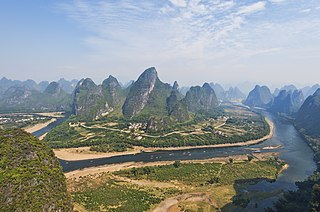
Guangxi, officially the Guangxi Zhuang Autonomous Region, is an autonomous region of the People's Republic of China, located in South China and bordering Vietnam and the Gulf of Tonkin. Formerly a province, Guangxi became an autonomous region in 1958. Its current capital is Nanning.
Xinjiang, officially the Xinjiang Uyghur Autonomous Region (XUAR), is a province-level administrative autonomous region of China.