Related Research Articles

The Arabian Sea is a region of sea in the northern Indian Ocean, bounded on the west by the Arabian Peninsula, Gulf of Aden and Guardafui Channel, on the northwest by Gulf of Oman and Iran, on the north by Pakistan, on the east by India, and on the southeast by the Laccadive Sea and the Maldives, on the southwest by Somalia. Its total area is 3,862,000 km2 (1,491,000 sq mi) and its maximum depth is 5,395 meters. The Gulf of Aden in the west connects the Arabian Sea to the Red Sea through the strait of Bab-el-Mandeb, and the Gulf of Oman is in the northwest, connecting it to the Persian Gulf.

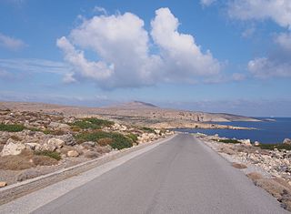
The Khuriya Muriya Islands are a group of five islands in the Arabian Sea, 40 km (25 mi) off the southeastern coast of Oman. The islands form part of the province of Shalim and the Hallaniyat Islands in the governorate of Dhofar.

The Persian Gulf, sometimes called the Arabian Gulf, is a mediterranean sea in West Asia. The body of water is an extension of the Indian Ocean located between Iran and the Arabian Peninsula. It is connected to the Gulf of Oman in the east by the Strait of Hormuz. The Shatt al-Arab river delta forms the northwest shoreline.

The United Arab Emirates is situated in the Middle East and West Asia, bordering the Gulf of Oman and the Persian Gulf, between Oman and Saudi Arabia; it is at a strategic location along the northern approaches to the Strait of Hormuz, a vital transit point for world crude oil. The UAE lies between 22°50′ and 26° north latitude and between 51° and 56°25′ east longitude. It shares a 19 km (12 mi) border with Qatar on the northwest, a 530 km (330 mi) border with Saudi Arabia on the west, south, and southeast, and a 450 km (280 mi) border with Oman on the southeast and northeast.
A royal yacht is a ship used by a monarch or a royal family. If the monarch is an emperor the proper term is imperial yacht. Most of them are financed by the government of the country of which the monarch is head. The royal yacht is most often crewed by personnel from the navy and used by the monarch and their family on both private and official travels.

Gottorf Castle is a castle and estate in the city of Schleswig, Schleswig-Holstein, Germany. It is one of the most important secular buildings in Schleswig-Holstein, and has been rebuilt and expanded several times in its over eight hundred years of history, changing from a medieval castle to a Renaissance fortress to a Baroque palace.
The Islamic Republic of Iran Navy or Iranian Navy, officially abbreviated NEDAJA, is the naval warfare service branch of Iran's regular military, the Islamic Republic of Iran Army (Artesh). It is one of Iran's two maritime military branches, alongside the Navy of the Islamic Revolutionary Guard Corps (IRGC).
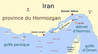
Larak Island is an island off the coast of Iran, which has been one of Iran's major oil export points since 1987. The narrowest part of the Strait of Hormuz at a distance of 24 miles (39 km) lies between this Iranian island and Oman's Quoin Island.
Jabal Al-Mebraḥ, also known by the name Jabal Yibir, is a 1,527 m (5,010 ft) tall mountain in the Emirate of Fujairah, the U.A.E.
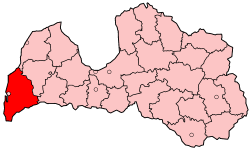
Liepāja District was an administrative division of Latvia, located in the Courland region, in the country's west.

The Fort of Our Lady of the Conception, also known as the Portuguese Castle, is a red stone fortress on Hormuz Island, Iran. It is one of the last surviving monuments of Portuguese colonial rule in the Persian Gulf. Ormuz was an important maritime city and a small kingdom near the entrance to the Persian Gulf. The original site of the city was on the north shore of the Gulf, about 30 miles east of the current Bandar Abbas. Around 1300, apparently in response to attacks from the Tartars, it moved to the small island of Gerun, which can be identified as the Organa of Nearcho, about 12 miles west and 5 miles from the coast.

The Battle of Jakobstadt was fought in the Great Northern War. It took place on 25 July 1704 (O.S.) / 26 July 1704 / 5 August 1704 (N.S.) between a Swedish army under Adam Ludwig Lewenhaupt and a combined Polish/Russian force under Great Hetman Michał Serwacy Wiśniowiecki at the town of Jēkabpils in the Duchy of Courland and Semigallia. The Swedes were victorious.

Al Hallaniyah is the largest and most populated of the Khuriya Muriya Islands, which belong to Oman. It is located in the center of the group, eight kilometers east of Al-Sawda, the closest island, and the second largest of the group. The area is 56 square kilometres (22 sq mi). The only village is located on the flat western part, with a population in the range of 100 to 150. It is reachable by boat or plane. An airstrip is located nearby.

Al Dhaferah was an amphibious transport ship in service with the Royal Navy of Oman since her construction in 1987. The vessel was capable of transporting 240 troops and worked alongside the royal yacht.
Sideros, is the outermost of a chain of two island-like peninsulas forming, with Itanos promontory, Cape Sidero. They are all three the summits of submarine elevations connected by rocky surface cols on which a road has been constructed to Cape Sidero Lighthouse, the elevated facsimile chapel of Saint Isidore, and Port Joannis, a cove of 2 fathoms (12 ft). There are ruins of an ancient temple of Athena destroyed by a tsunami and facilities of the Kyriamadi Naval Station. Kyriamadi is the other island-like peninsula in the chain. Administratively the cape lies within the Itanos municipal unit, Sitia Municipality, Lasithi regional unit, and Crete region.

Burhaniye National Forces Culture Museum is a museum in Burhaniye district of Balıkesir Province in western Turkey.
The Oman Royal Yacht Squadron is the Sultan of Oman's personal fleet of pleasure craft ranging from the grand Al Said through to the traditional wooden-hulled sailing vessel Zinat al Bihaar.
Didamar Lighthouse is the northernmost lighthouse in Oman, located on Little Quoin Island in the As Salamah Archipelago north of Musandam Peninsula in the Strait of Hormuz.

Fulk Al Salamah is a superyacht in service with the Oman Royal Yacht Squadron since her completion in 2016. She was first announced in 2014 as project Saffron. She joined the Lürssen superyacht Al Said in the capital Muscat as part of the royal fleet. At 164 metres, Fulk Al Salamah is the second longest yacht in the world as of 2022. She replaced a previous ship called Fulk Al Salamah which was renamed Al Dhaferah.

Wood Island is a former island in Marin County, California, formerly in the Corte Madera Creek but now surrounded by land. Its coordinates are 37°56′37″N122°30′42″W, and the United States Geological Survey measured its elevation as 13 ft (4.0 m) in 1981. It appears in a 1954 USGS map of the region. In the 1960s, its principal owner was Spero Spiliotis. In 1969, the city of Larkspur passed a resolution of intent to annex the island, and in the 1970s, a ferry terminal had been proposed.