
The NATO Integrated Air Defense System is a command and control network combining radars and other facilities spread throughout the NATO alliance's air defence forces. It formed in the mid-1950s and became operational in 1962 as NADGE. It has been constantly upgraded since its formation, notably with the integration of Airborne Early Warning aircraft in the 1970s. The United Kingdom maintained its own network, but was fully integrated with the network since the introduction of the Linesman/Mediator network in the 1970s. Similarly, the German network maintained an independent nature through GEADGE.
Wireless communication is the transfer of information between two or more points that do not use an electrical conductor as a medium by which to perform the transfer. The most common wireless technologies use radio waves. With radio waves, intended distances can be short, such as a few meters for Bluetooth or as far as millions of kilometers for deep-space radio communications. It encompasses various types of fixed, mobile, and portable applications, including two-way radios, cellular telephones, personal digital assistants (PDAs), and wireless networking. Other examples of applications of radio wireless technology include GPS units, garage door openers, wireless computer mouse, keyboards and headsets, headphones, radio receivers, satellite television, broadcast television and cordless telephones. Somewhat less common methods of achieving wireless communications include the use of other electromagnetic wireless technologies, such as light, magnetic, or electric fields or the use of sound.

Base station is – according to the International Telecommunication Union's (ITU) Radio Regulations (RR) – a "land station in the land mobile service."
Creepschool is a Swedish-French-Canadian animated series by Alphanim, the CINAR Corporation, Happy Life and France 3 about four kids who find themselves at a spooky boarding school. The basic concept was created by Torbjörn Jansson, which was then substantially re-worked and developed by the co-head-writers Kristina Mansfeld and Per Carlsson into the series it is today. They also wrote all the storylines. Creepschool has been compared to Gravedale High.

Royal Air Force Boulmer or RAF Boulmer is a Royal Air Force station near Alnwick in Northumberland, England, and is home to Aerospace Surveillance and Control System (ASACS) Force Command, Control and Reporting Centre (CRC) Boulmer.
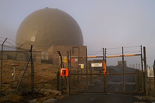
Remote Radar Head Saxa Vord or RRH Saxa Vord, is a Royal Air Force radar station located on the island of Unst, the most northern of the Shetland Islands in Scotland. As of July 2019 it is once more a fully operational radar station, after closure in 2006. The station's motto Praemoneo de Periculis reflects its role. RAF Saxa Vord is further north than Saint Petersburg in Russia, and on the same latitude as Anchorage, Alaska. The station was named after Saxa Vord, which is the highest hill on Unst at 935 ft (285 m). It holds the unofficial British record for wind speed, which in 1992 was recorded at 197 mph (317 km/h) — just before the measuring equipment blew away.

Remote Radar Head Neatishead or RRH Neatishead is an air defence radar station operated by the Royal Air Force. It is located approximately 11 kilometres (6.8 mi) north east of Norwich in Norfolk, England.
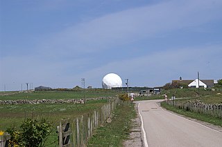
RemoteRadarHeadStaxton Wold or RRH Staxton Wold is an air defence radar station operated by the Royal Air Force, located near Scarborough in North Yorkshire, England.
The Asahi Broadcasting Group Holdings Corporation is a certified broadcasting holding company headquartered in Osaka, Japan. Until March 31, 2018, it was a radio and television broadcaster serving in the Kansai region. On April 1, 2018, Asahi Radio Broadcasting Corporation took over radio broadcasting business, and Asahi Television Broadcasting Corporation took over TV broadcasting business, employees, and administrator for ABC website.

Mount Kent is a mountain on East Falkland, Falkland Islands. and is 1,093 ft (333 m) high It is located north of Mount Challenger.

Radio is the technology of signaling and communicating using radio waves. Radio waves are electromagnetic waves of frequency between 30 hertz (Hz) and 300 gigahertz (GHz). They are generated by an electronic device called a transmitter connected to an antenna which radiates the waves, and received by another antenna connected to a radio receiver. Radio is very widely used in modern technology, in radio communication, radar, radio navigation, remote control, remote sensing and other applications.

Remote Radar Head Trimingham or RRH Trimingham is a TPS-77 radar station situated on the coast in the English county of Norfolk. The site is located on the coast road between Cromer and Mundesley, 1 kilometre east of the village of Trimingham. The radar station is a satellite station of RAF Neatishead. This radar station is controlled and maintained by a section of Radar Technicians and Operators and supported by a team of Ground Engineers. Trimingham provides extensive coverage of the East coast of the United Kingdom and helps contribute to the recognised air picture and defence of the United Kingdom. The type 93 became operational on the site in April 1997.
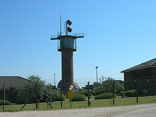
Remote Radar Head Buchan or RRH Buchan is an air defence radar station operated by the Royal Air Force. It is located at Stirling Hill, 3.2 kilometres (2.0 mi) south of Peterhead on the Aberdeenshire coast of North East Scotland.

In telecommunications, 5G is the fifth generation technology standard for broadband cellular networks, which cellular phone companies began deploying worldwide in 2019, and is the planned successor to the 4G networks which provide connectivity to most current cellphones. 5G networks are predicted to have more than 1.7 billion subscribers worldwide by 2025, according to the GSM Association. Like its predecessors, 5G networks are cellular networks, in which the service area is divided into small geographical areas called cells. All 5G wireless devices in a cell are connected to the Internet and telephone network by radio waves through a local antenna in the cell. The main advantage of the new networks is that they will have greater bandwidth, giving higher download speeds, eventually up to 10 gigabits per second (Gbit/s). Due to the increased bandwidth, it is expected the networks will increasingly be used as general internet service providers for laptops and desktop computers, competing with existing ISPs such as cable internet, and also will make possible new applications in internet of things (IoT) and machine to machine areas. 4G cellphones are not able to use the new networks, which require 5G enabled wireless devices.

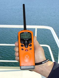
A remote radio head (RRH), also called a remote radio unit (RRU) in wireless networks, is a remote radio transceiver that connects to an operator radio control panel via electrical or wireless interface. When used to describe aircraft radio cockpit radio systems, the control panel is often called the radio head.

Toyota Entune is an integrated multimedia navigation and telematics system for Toyota automobiles, providing satellite-based information on traffic, weather, sports scores, stocks, Windows Media Player and fuel prices via subscription through SiriusXM. When connected to a compatible cellular phone running the Entune app, via radio or USB cable, the system provides a browser and other apps, including those from music services such as iHeartRadio, Pandora and XM Satellite Radio. The cell phone app has iOS, Android, and Blackberry versions; to use this feature, a cell phone data plan is required. The system can be controlled with voice recognition, and may include the “Safety Connect” personalization system.
C-RAN (Cloud-RAN), sometimes referred to as Centralized-RAN, is an architecture for cellular networks. 9 years after it was disclosed in patent applications filed by U.S. companies. Simply speaking, C-RAN is a centralized, cloud computing-based architecture for radio access networks that supports 2G, 3G, 4G and future wireless communication standards. Its name comes from the four 'C's in the main characteristics of C-RAN system, "Clean, Centralized processing, Collaborative radio, and a real-time Cloud Radio Access Network".
IEEE 1914.1 is a standard for packet-based fronthaul transport networks developed under IEEE 1914 Next Generation Fronthaul Interface – NGFI (xhaul) Working Group. NGFI (xhaul) working group is sponsored by IEEE Communications Society/Standards Development Board (COM/SDB). IEEE 1914.1 standardizes architecture and requirements for mobile fronthaul network – spanning between cell sites and centralized baseband locations in Centralized, Collaborative, Cloud and Clean Radio Access Network C-RAN.

Mount Alice is a mountain rising to 361 m (1,180 ft) at the south extremity of West Falkland, Falkland Islands in the South Atlantic. It is situated between the bays of Port Stephens and Port Albemarle, 12.3 km (7.6 mi) due north of Cape Meredith.
Byron Heights is a mountain rising to 497 m (1,630 ft) at the northwest extremity of West Falkland, Falkland Islands in the South Atlantic. It is situated 11.65 km (7.24 mi) southeast of Hope Point.