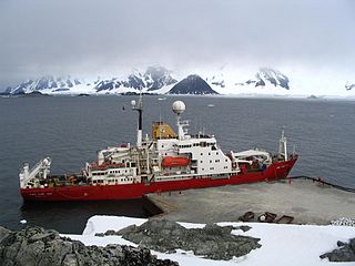
Noosfera is a polar supply and research ship operated by the National Antarctic Scientific Center of Ukraine. Until 2021, she was operated by the British Antarctic Survey and named RRS James Clark Ross.
A Royal Research Ship (RRS) is a merchant navy vessel of the United Kingdom that conducts scientific research for Her Majesty's Government. Organisations operating such ships include; the Natural Environment Research Council (NERC), the British Antarctic Survey (BAS) and the National Oceanography Centre (NOC). A warrant from the Queen is required before a ship can be designated as an RRS.
The RRS John Biscoe was a supply and research vessel used by the British Antarctic Survey between 1956 and 1991.
John Biscoe was an English mariner and explorer who commanded the first expedition known to have sighted the areas named Enderby Land and Graham Land along the coast of Antarctica. The expedition also found a number of islands in the vicinity of Graham Land, including the Biscoe Islands that were named after him.
The British Antarctic Survey (BAS) is the United Kingdom's national polar research institute. It has a dual purpose, to conduct polar science, enabling better understanding of global issues, and to provide an active presence in the Antarctic on behalf of the UK. It is part of the Natural Environment Research Council (NERC). With over 400 staff, BAS takes an active role in Antarctic affairs, operating five research stations, one ship and five aircraft in both polar regions, as well as addressing key global and regional issues. This involves joint research projects with over 40 UK universities and more than 120 national and international collaborations.

HMNZS Endeavour was a Royal New Zealand Navy Antarctic support vessel. She was the first of three ships in the Royal New Zealand Navy to bear that name.

Adelaide Anchorage is an area of safe anchorage lying west of Avian Island, off the south end of Adelaide Island. It is the anchorage normally used by ships visiting Adelaide research station. Charted by members of the RRS John Biscoe and the Royal Navy Hydrographic Survey Unit in January–March 1962.
Hibbert Rock is a drying rock lying SE of League Rock located in the Quest Channel off the Southern tip of Adelaide Island. Named by the UK Antarctic Place-Names Committee for William Hibbert, ship's Engineer of the RRS John Biscoe (1956) from the late 1950s to 1960s, the ship which assisted the Royal Navy Hydrographic survey Unit in surveying the area between 1962–1963.

Mount Nygren is an outstanding pointed mountain, bearing the aspect of a stark rock nunatak of pyramidal shape, which rises sharply above the middle of Hotine Glacier on Kyiv Peninsula in western Graham Land, Antarctica.
Ward Islands is a group of two small islands and off-lying rocks forming the southern part of the Amiot Islands, off the southwest part of Adelaide Island. Named by the United Kingdom Antarctic Place-Names Committee (UK-APC) for Herbert G.V. Ward, Chief Engineer of RRS John Biscoe, 1948–1962, which ship assisted the Royal Navy Hydrographic Survey Unit which charted this group in 1963.
Cumbers Reef is a group of rocks aligned in an arc forming the north and west parts of the Amiot Islands, off the southwest part of Adelaide Island. It was named by the UK Antarctic Place-Names Committee for Roger N. Cumbers, 3rd officer of RRS John Biscoe, 1961–62, the ship which assisted the Royal Navy Hydrographic Survey Unit in the charting of this area in 1963.

Joubert Rock is a rock with a least depth of 12.5 metres (41 ft), lying 9 kilometres (5 nmi) southwest of Pod Rocks and 17 kilometres (9 nmi) west-southwest of Millerand Island, in Marguerite Bay, Antarctica. It was charted by the Hydrographic Survey Unit from RRS John Biscoe in 1966, and was named for Arthur B.D. Joubert, third officer of the John Biscoe and officer of the watch when the rock was discovered.
Johnston Passage is a channel in Antarctica, running north–south and separating the Amiot Islands from the southwestern part of Adelaide Island. It was named by the UK Antarctic Place-Names Committee for Captain William Johnston, from 1956–62 Master of RRS John Biscoe, the ship which assisted the Royal Navy Hydrographic Survey Unit in charting this area in 1963.
Fuller Rock is a rock awash, one of the principal dangers to ships on the north side of Faure Passage, Marguerite Bay, Antarctica, about 7.8 kilometres (4.2 nmi) south-southwest of Dismal Island. It was charted by a Royal Navy Hydrographic Survey Unit from RRS John Biscoe in January 1973 and named after Lieutenant Andrew C. Fuller, Royal Navy, who directed the survey.
Fullastern Rock is an isolated submerged rock lying in the middle of Johnston Passage 7 nautical miles (13 km) west-northwest of Cape Adriasola, Adelaide Island. The rock is potentially dangerous to ships and was so named when the RRS John Biscoe was compelled to go full astern to avoid this hazard.
Elliott Passage is a marine channel running northeast–southwest between the southeast coast of Adelaide Island and Jenny Island. It was named by the UK Antarctic Place-Names Committee in 1984 after Captain Christopher R. Elliott, Master of the RRS John Biscoe from 1975, having also served in other officer positions on the John Biscoe and the RRS Bransfield from 1967.
The Glover Rocks are a group of rocks lying northwest of Avian Island, off the south end of Adelaide Island, Antarctica. They were named by the UK Antarctic Place-Names Committee for John F. Glover, 3rd Engineer of RRS John Biscoe (1962–63), the ship assisting the Royal Navy Hydrographic Survey Unit which charted the feature in 1963.
Launch Rock is a submerged rock lying southwest of the Glover Rocks, off the south end of Adelaide Island, Antarctica. It was named by the UK Antarctic Place-Names Committee to commemorate the unnamed launch from RRS John Biscoe that was used by the Hydrographic Survey Unit which charted this area in 1963.
RRS Discovery is a wooden three-masted British ship launched in 1901, and is most associated with the Discovery Expedition to the Antarctic led by Robert Falcon Scott and Ernest Shackleton.