
Santa Cruz is the largest city and the county seat of Santa Cruz County, in Northern California. As of the 2020 census, the city population was 62,956. Situated on the northern edge of Monterey Bay, Santa Cruz is a popular tourist destination, owing to its beaches, surf culture, and historic landmarks.

Boulder Creek is a small rural mountain community in the coastal Santa Cruz Mountains. It is a census-designated place (CDP) in Santa Cruz County, California, with a population of 5,429 as of the 2020 census. Throughout its history, Boulder Creek has been home to a logging town and a resort community, as well as a counter-culture haven. Today, it is identified as the gateway to Big Basin Redwoods State Park.
Henry Cowell Redwoods State Park is a state park of California, United States, preserving mainly forest and riparian areas in the watershed of the San Lorenzo River, including a grove of old-growth coast redwood. It is located in Santa Cruz County, primarily in the area between the cities of Santa Cruz and Scotts Valley, near the community of Felton and the University of California at Santa Cruz. The park includes a non-contiguous extension in the Fall Creek area north of Felton. The 4,623-acre (1,871 ha) park was established in 1953.
Pablo Vicente de Solá (1761–1826) was a Spanish officer and the twelfth and last Spanish colonial governor of Alta California (1815-1822). He was born in Mondragón, Gipuzkoa, Spain.
El Rancho Rinconada de los Gatos was a 6,631-acre (26.83 km2) Mexican land grant in present-day Santa Clara County, California made in 1840 by Governor Juan Alvarado to Jose Maria Hernandez and Sebastian Fabian Peralta. Located in the southern San Francisco Bay Area, the grant included present-day Los Gatos and Monte Sereno, along with about a third of Campbell. It also included small sections of present-day San Jose, Saratoga and unincorporated Santa Clara County. Los Gatos Creek flowed through the center of the rancho. The name means "corner of the cats" and is derived from the cougars that are still present in the nearby hills, as well as the "corner" formed by the narrowing gap between El Sereno and El Sombroso mountains.

Arana Gulch is a creek and landform that forms part of the southeastern boundary of the city of Santa Cruz, California. The creek begins in the Santa Cruz Mountains and flows southwest into Monterey Bay via what was once called Woods Lagoon, now the Santa Cruz Small Craft Harbor.
Zayante is a census-designated place (CDP) in Santa Cruz County, California. It is a residential area located on Zayante Creek. Zayante sits at an elevation of 699 feet (213 m). The 2020 United States census reported Zayante's population was 729.

Wilder Ranch State Park is a California State Park on the Pacific Ocean coast north of Santa Cruz, California. The park was formerly a dairy ranch, and many of the ranch buildings have been restored for use as a museum. There are no campgrounds; a day-use parking lot provides access to the museum. Dogs are prohibited on the trails, but many trails allow bikes and/or horses. The long trails and ocean views make the area a favorite of hikers, equestrians and mountain bikers. Public beaches continue to the north in Coast Dairies State Park.

Rancho Rincón de los Bueyes was a 3,127-acre (12.65 km2) land grant in present-day Los Angeles County, California, given in 1821 to Bernardo Higuera and Cornelio Lopez by Pablo Vicente de Sola, the Spanish Governor of Alta California. In 1843, this Spanish grant was confirmed by Mexican Governor Manuel Micheltorena. Rincón, translated from Spanish, means corner or nook, and Bueyes are oxen or steer.
Rancho El Rincón was a 4,431-acre (17.93 km2) Mexican land grant in present-day San Bernardino County and Riverside County, California given in 1839 to Juan Bandini by Governor Juan Alvarado. El rincón means "the corner" in Spanish. The grant, located south of present-day Chino, was bounded on the east by Rancho Jurupa, on the south by the Santa Ana River, on the west by Rancho Cañón de Santa Ana, and extending northerly from the river one league. The rancho lands include Prado Regional Park.
Rancho Rincon de San Francisquito was a 8,418-acre (34.07 km2) Mexican land grant in present-day Santa Clara County, California given in 1841 by Governor Juan Alvarado to José Peña. The name means "corner or bend of the San Francisquito" referring to San Francisquito Creek. The grant extended along Matadero Creek to the hills and included the southern part of present-day Palo Alto and the southern part of the Stanford University campus.
Rancho Rincón de las Salinas y Potrero Viejo was a 4,446-acre (17.99 km2) Mexican land grant, largely within present day southeastern San Francisco, California, and extending to San Mateo County, California.

Rancho Punta del Año Nuevo was a 17,753-acre (71.84 km2) Mexican land grant in present day San Mateo County, California given in 1842 by Governor Juan B. Alvarado to Simeon Castro. Following statehood, the land grant was within Santa Cruz County; however, an 1868 boundary adjustment gave the land to San Mateo County. The grant extended along the Pacific coast from Rancho Butano and Arroyo de los Frijoles on the north, past Pigeon Point, Franklin Point to Point Año Nuevo on the south.
Isaac Graham was a fur trader, mountain man, and land grant owner in 19th century California.
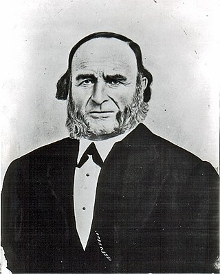
Rancho Cañada del Rincon en el Rio San Lorenzo was a 5,827-acre (23.58 km2) Mexican land grant in present-day Santa Cruz County, California given in 1843 by Governor Manuel Micheltorena, and confirmed in 1846 by Governor Pío Pico, to Pedro Sainsevain. The name means "valley on a corner on the San Lorenzo River". The grant was north of present-day Santa Cruz on the San Lorenzo River.
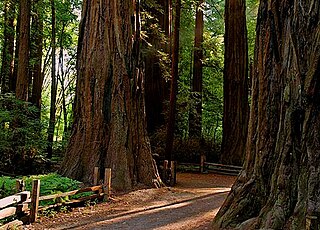
Rancho Zayante was a 2,658-acre (10.76 km2) Mexican land grant in present-day Santa Cruz County, California. The grant, measuring one league by one-half league, straddled Zayante Creek and the San Lorenzo River. It included most of the present-day communities of Felton, Mount Hermon and Olympia, along with parts of Ben Lomond, Quail Hollow and Brackney, but not Zayante.
Rancho Rincón del Sanjón was a 2,230-acre (9.0 km2) Mexican land grant in present-day Monterey County, California given in 1840 by Governor Juan B. Alvarado to José Eusebio Boronda. The name means "corner of Sanjo del Alisal". The grant was located on the north side of the Sanjo del Alisal,, between Cooper's Rancho Bolsa del Potrero y Moro Cojo on the west, Castro's Rancho Sausal on the east, and bordering Espinosa's Rancho Bolsa de las Escorpinas on the north. The grant was on the northwest of present-day Salinas, where Boronda, California is located.
Rancho Potrero de San Luis Obispo was a 3,506-acre (14.19 km2) Mexican land grant in present day San Luis Obispo County, California given in 1842 by Governor Juan Alvarado to María Concepción Boronda. Potrero means "pasture" in Spanish. The grant was north of present day San Luis Obispo, and encompassed Cal Poly San Luis Obispo.
Rancho Potreros de San Juan Capistrano was a 1,168-acre (4.73 km2) Mexican land grant in present-day Orange County and Riverside County, California given in 1845 by Governor Pío Pico to John Forster. The grant was composed of three detached tracts, called, Rancho Potrero los Pinos, Rancho Potrero el Cariso, and Rancho Potrero de la Cienega. The grants were located in the Santa Ana Mountains in the present-day Cleveland National Forest in the southeast corner of the Orange County and western Riverside County.
Rancho Potrero de San Francisco or Rancho Potrero Nuevo was approximately 1,000-acre (4.0 km2) Mexican land grant in the present day Potrero Hill neighborhood of San Francisco, California.

