
The invasion of the Waikato became the largest and most important campaign of the 19th-century New Zealand Wars. Hostilities took place in the North Island of New Zealand between the military forces of the colonial government and a federation of Māori tribes known as the Kingitanga Movement. The Waikato is a territorial region with a northern boundary somewhat south of the present-day city of Auckland. The campaign lasted for nine months, from July 1863 to April 1864. The invasion was aimed at crushing Kingite power and also at driving Waikato Māori from their territory in readiness for occupation and settlement by European colonists. The campaign was fought by a peak of about 14,000 Imperial and colonial troops and about 4,000 Māori warriors drawn from more than half the major North Island tribal groups.

The Waikato River is the longest river in New Zealand, running for 425 kilometres (264 mi) through the North Island. It rises on the eastern slopes of Mount Ruapehu, joining the Tongariro River system and flowing through Lake Taupō, New Zealand's largest lake. It then drains Taupō at the lake's northeastern edge, creates the Huka Falls, and flows northwest through the Waikato Plains. It empties into the Tasman Sea south of Auckland, at Port Waikato. It gives its name to the Waikato region that surrounds the Waikato Plains. The present course of the river was largely formed about 17,000 years ago. Contributing factors were climate warming, forest being reestablished in the river headwaters and the deepening, rather than widening, of the existing river channel. The channel was gradually eroded as far up river as Piarere, leaving the old Hinuera channel through the Hinuera Gap high and dry. The remains of the old course are seen clearly at Hinuera, where the cliffs mark the ancient river edges. The Waikato's main tributary is the Waipā River, which converges with it at Ngāruawāhia.

Huntly is a town in the Waikato district and region of the North Island of New Zealand. It was on State Highway 1, 95 kilometres (59 mi) south of Auckland and 32 kilometres (20 mi) north of Hamilton. It is situated on the North Island Main Trunk (NIMT) railway and straddles the Waikato River. Huntly is within the Waikato District which is in the northern part of the Waikato region local government area.
Wiremu Kīngi Te Rangitāke, Māori Chief of the Te Āti Awa Tribe, was leader of the Māori forces in the First Taranaki War.
Lieutenant Colonel William Temple VC was a British Army officer and an Irish recipient of the Victoria Cross (VC), the highest award for gallantry in the face of the enemy that can be awarded to British and Commonwealth forces.

Lieutenant Colonel Arthur Frederick Pickard was a British Army officer and courtier. For his actions in New Zealand in 1863, he was awarded the Victoria Cross, the highest award for gallantry in the face of the enemy that can be awarded to British and Commonwealth forces. After further service and promotion in the Royal Artillery, Pickard was appointed an Equerry to the Duke of Connaught and Strathearn in 1871; seven years later, he was made Assistant Keeper of the Privy Purse and Assistant Private Secretary to the Queen and promoted to lieutenant colonel, but died of tuberculosis in France, aged 35, less than two years later.
Waikato Tainui, Waikato or Tainui is a group of Māori iwi based in Waikato Region, in the western central region of New Zealand's North Island. It is part of the larger Tainui confederation of Polynesian settlers who arrived to New Zealand on the Tainui waka. The tribe is named after the Waikato River, which plays a large part in its history and culture.
Events from the year 1833 in Ireland.
The Waikato Expressway is a dual carriageway section of State Highway 1 in New Zealand's Waikato region. Constructed in stages, it forms part of the link between Auckland and Hamilton. Currently stretching from Auckland to south of Cambridge, the first section of the highway was built in 1993. Throughout its lifetime, it has undergone many upgrades to optimise traffic flow throughout the Waikato region, including various bypasses of many towns in the region, culminating with Hamilton in 2022.
Rangiriri was a rural New Zealand parliamentary electorate in the Waikato Region from 1978 to 1984.
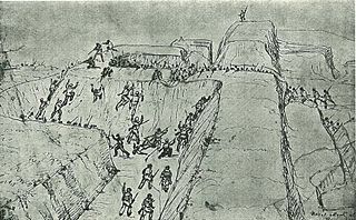
The Battle of Rangiriri was a major engagement in the invasion of Waikato, which took place on 20–21 November 1863 during the New Zealand Wars. More than 1400 British troops defeated about 500 warriors of the Kingitanga, which was resisting the expansion of British settlement and colonial rule in the North Island. The battle cost both sides more than any other engagement of the land wars and also resulted in the capture of 180 Māori prisoners, further reducing the Kingitanga ability to oppose the far larger British force.
Hoani Te Puna i Rangiriri Taipua was a 19th-century Māori member of the New Zealand House of Representatives.

The Whangamarino Wetland in the Waikato District is the second largest wetland complex of the North Island of New Zealand. Encompassing a total area of more than 7200 hectares, the Department of Conservation Te Papa Atawhai manages 5,923 hectares of peat bog, swamp, mesotrophic lags, open water and river systems listed as a wetland of international importance under the Ramsar Convention. Fish and Game New Zealand are the second largest landowner, managing 748 hectares of the wetland primarily as gamebird hunting habitat.

Mercer is a village in the Waikato District Council area of the Waikato region of the North Island of New Zealand. It is 70 km north of Hamilton and 58 km south of Auckland, on the east bank of the Waikato River, 2 km south of its confluence with the Mangatāwhiri River.
Rangiriri is a rural community in the Waikato District and Waikato region of New Zealand's North Island. It is located on the Waikato River near Lake Waikare in the Waikato District. State Highway 1 now bypasses Rangiriri.
Lake Whangape is shallow, supertrophic, lateral and the second largest lake in the lower Waikato River basin in New Zealand. One source said the name translated to 'a large sheet of water', another that it was a chief's name.

Ohinewai Railway Station was a flag station on the North Island Main Trunk line, serving Ohinewai in the Waikato District of New Zealand, 59 mi (95 km) south of Auckland. It was 8.18 km (5.08 mi) north of Huntly, 7.26 km (4.51 mi) south of Rangiriri and 33 ft (10 m) above sea level. It was in the village, just north of Tahuna Rd.
Glen Murray is a rural community in the Waikato District and Waikato region of New Zealand's North Island, on Highway 22, about 6 km (3.7 mi) up the Tikotiko Stream from Lake Whangape. In 2013 the population of meshblock 0846601, which includes Glen Murray, was 42. It has a garage and a War Memorial Hall, which opened in 1952. It is named after William Murray, who moved from Piako in 1885.

Rangiriri was a flag station about 2 km (1.2 mi) south-east of Rangiriri, on the North Island Main Trunk line, in the Waikato District of New Zealand, 56 mi (90 km) south of Auckland. It was 588.2 km (365.5 mi) north of Wellington, 3.32 km (2.06 mi) south of Te Kauwhata, 7.26 km (4.51 mi) north of Ohinewai and 9 m (30 ft) above sea level.
The Rangiriri was a 19th-century paddle-steamer gunboat used on the Waikato River in New Zealand. It brought the first Pakeha settlers to Hamilton in 1864 and served as a riverboat until it was wrecked in 1889. It is now located on the shore in Memorial Park, Hamilton East. It is the oldest surviving iron-hulled boat in new Zealand.