
Austrheim is a municipality in the Nordhordland region of Hordaland county, Norway. The administrative centre of the municipality is the village of Årås. Other villages in the municipality include Austrheim and Kaland. The Mongstad industrial area lies along the border of Austrheim and neighboring Lindås municipality. The westernmost point of mainland Norway lies in the municipality at Vardetangen.

Dønna is a municipality in Nordland county, Norway. It is part of the Helgeland region. The administrative centre of the island municipality is the village of Solfjellsjøen. Other villages include Bjørn, Dønnes, Hestad, Sandåker, and Vandve. The main island of Dønna is connected to the neighboring municipality of Herøy to the south by the Åkviksundet Bridge.
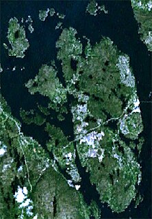
Træna is a municipality in Nordland county, Norway. It is part of the Helgeland traditional region. The administrative centre of the municipality is the island/village of Husøya. Other population centres include Selvær and Sanna.
Rødøy is a municipality in Nordland county, Norway. It is part of the Helgeland traditional region. The administrative centre of the municipality is the village of Vågaholmen. Other villages include Gjerøy, Jektvika, Kilboghamn, Melfjordbotn, Oldervika, Sørfjorden, and Tjong. The municipality consists of many islands to the west of Norway's second biggest glacier, Svartisen.

Andøy is the northernmost municipality in Nordland county, Norway. It is part of the Vesterålen archipelago. The main island in the municipality is Andøya. The administrative centre of the municipality is the village of Andenes. Other villages in the municipality include Bjørnskinn, Bleik, Dverberg, Fiskenes, Fornes, Nordmela, Risøyhamn, Skarstein, Å, Åknes, and Åse.
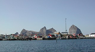
Leirvik is a town and the administrative centre of Stord municipality in Hordaland county, Norway. The town lies along the southern coast of the large island of Stord, along the Hardangerfjorden. The town gained "town status" in 1997. The town includes the Eldøyane peninsula where the large Kværner Stord industrial area is located.
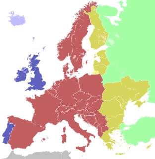
Central European Time (CET), used in most parts of Europe and a few North African countries, is a standard time which is 1 hour ahead of Coordinated Universal Time (UTC). The time offset from UTC can be written as UTC+01:00. The same standard time, UTC+01:00, is also known as Middle European Time and under other names like Berlin Time, Warsaw Time and Romance Standard Time (RST), Paris Time or Rome Time.

Magerøya is a large island in Finnmark county, in the extreme northern part of Norway. The island lies along the Barents Sea in Nordkapp Municipality, just north of the Porsanger Peninsula. The mouth of Porsangerfjorden lies off the east coast of the island.
Eastern European Time (EET) is one of the names of UTC+02:00 time zone, 2 hours ahead of Coordinated Universal Time. The zone uses daylight saving time, so that it uses UTC+03:00 during the summer.

Alsta is an island in the municipalities of Alstahaug and Leirfjord in Nordland county, Norway. The island is surrounded by the Vefsnfjorden to the east, the Leirfjorden to the north, and the Alstenfjorden to the south and west. The eastern part of the island is dominated by the Seven Sisters mountain range which has five mountains that are more than 1,000 metres (3,300 ft) tall, while the western part of the island is relatively flat and it is the location of the town of Sandnessjøen and the village of Søvika in the south.

Sotra or Store Sotra is the name of a large island in Hordaland county, Norway, located just west of the city of Bergen. It is part of a pair of islands called Sotra that are part of a large archipelago stretching from Fedje southwards along the coast of Norway. The larger island of the two is Store Sotra, and the smaller of the two is Litlesotra. Roughly 30,500 people live on the two islands of Sotra.

Litle Sokumvatnet is a lake that lies in Gildeskål Municipality in Nordland county, Norway. Litle Sokumvatnet lies directly northeast of the larger lake Sokumvatnet. The lake serves as a reservoir for the Forså Hydroelectric Power Station.
Litlumvatnet (Norwegian), Lill-Uman (Swedish), or Jovsjaevrie (Southern Sami) is a lake on the border of Norway and Sweden. The Norwegian side lies in Rana Municipality in Nordland county and the Swedish side lies in Storuman Municipality in Västerbotten County. The lake lies about 40 kilometres (25 mi) southeast of the town of Mo i Rana. The lake is 5.24 square kilometres (2.02 sq mi) and about 1.8 square kilometres (0.69 sq mi) lies inside Norway and the rest lies in Sweden.
Sokumvatnet is a lake that lies in the municipality of Gildeskål in Nordland county, Norway. Sokumvatnet is located about 15 kilometres (9.3 mi) southeast of the village of Inndyr. It lies just south of the lake Litle Sokumvatnet and northeast of the lake Langvatnet. The lake serves as a reservoir for the Sundsfjord Hydroelectric Power Station.
Solbjørnvatnet is a lake in Flakstad Municipality in Nordland county, Norway. The 5.02-square-kilometre (1.94 sq mi) lake is located on the northern part of the island of Moskenesøya, less than 900 metres (3,000 ft) west of the European route E10 highway. The mountain Klokktinden lies on the southern shore of the lake.

Tonnes is a village in Lurøy Municipality in Nordland county, Norway. It is located on the mainland coast, about 100 kilometres (62 mi) northwest of the town of Mo i Rana. It lies on a peninsula in the far northern edge of the municipality, to the north of the islands of Aldra and Lurøya, east of Storselsøya, and south of Rangsundøya.

Norwegian Bay is an Arctic ocean waterway in Qikiqtaaluk Region. Nunavut, Canada. Amund Ringnes Island is to the northwest, and Axel Heiberg Island to the north, Ellesmere Island is to the east, and Devon Island is to the south. Six islands lie within Norwegian Bay:
Litlesotra, or sometimes Lille Sotra, is an island in Fjell municipality in Hordaland county, Norway. It is part of the Sotra island group which makes up the southern part of a larger archipelago of islands from Fedje south through Øygarden. The 16.7-square-kilometre (6.4 sq mi) island has about 10,000 residents. The main settlement on the island is Straume. Other settlements include Knarrevik, Foldnes, and Brattholmen. The island is connected to the mainland via the Sotra Bridge. It is also connected to the large island of Sotra, via a series of bridges over the island of Bildøy.

Storselsøya is an island in Nordland county, Norway. The island is divided between two municipalities: Rødøy in the north and Lurøy in the south. The island of Nesøya lies to the west, the island of Lurøya lies to the south, and the mainland village of Tonnes lies to the east.

Dønna is the largest island in Dønna Municipality in Nordland county, Norway. The 138-square-kilometre (53 sq mi) island lies off the west coast of the mainland of Helgeland, Norway. The islands of Løkta and Tomma lie northeast of the island, the islands of Vandve and Åsvær lie to the west, and the islands of Herøy and Alsta lie to the south.


