
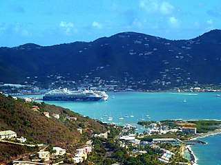
Raphune is a settlement on the island of Saint Thomas in the United States Virgin Islands.
The Al Cohen's Plaza mall is located in Raphune.
Raphune is a settlement on the island of Saint Thomas in the United States Virgin Islands.
The Al Cohen's Plaza mall is located in Raphune.

The United States Virgin Islands are a group of several dozen islands and cays located in the Caribbean, about 1,100 miles (1,770 km) southeast of Florida, 600 miles (966 km) north of Venezuela, 40 miles (64 km) east of Puerto Rico, and immediately west and south of the British Virgin Islands.
Clarence Township is a civil township located in northeast Calhoun County in the U.S. state of Michigan. It is part of the Battle Creek, Michigan Metropolitan Statistical Area. The population was 1,903 at the 2020 census. The township was originally named Pinkney Township.

Millersburg is a village in Presque Isle County of the U.S. state of Michigan. The population was 206 at the 2010 census. The village is within Case Township.
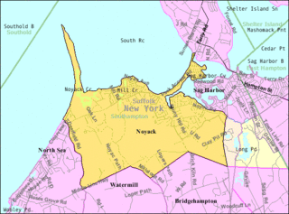
Noyack is a hamlet and census-designated place (CDP) in Suffolk County, New York, United States. The CDP population was 4,325 at the 2020 census.
Whitfield is a census-designated place (CDP) in Berks County, Pennsylvania, United States. The population was 4,733 at the 2010 census.

Albreda is a historic settlement in the Gambia on the north bank of the Gambia River, variously described as a 'trading post' or a 'slave fort'. It is located near Jufureh in the North Bank Division and an arch stands on the beach connecting the two places. As of 2008, it has an estimated population of 1,776.

Cruz Bay, U.S. Virgin Islands is the main town on the island of Saint John in the United States Virgin Islands. According to the 2000 census, Cruz Bay had a population of 2,743.
Area code 340 is the local telephone area code of the U.S. Virgin Islands. The 340 area code was created during a split from the original 809 area code, which began permissive dialing on 1 June 1997 and ended 30 June 1998.
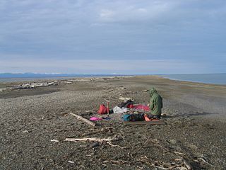
Arey Island is a 7-mile-long (11 km) barrier island on the North Slope of the U.S. state of Alaska. It is located west of Barter Island, between Arey Lagoon and the Beaufort Sea. In the past, visitors and guides have used Arey Island as a departure point from the coastal plain. Though this may still be possible, most of Arey Island is private land, so permission for its use must be obtained from, and the access fees paid to, the Kaktovik Inupiat Corporation (KIC). Without this permission, public access to Arey Island is limited.

Sports and Fitness Center is an indoor sporting arena located in Saint Thomas, United States Virgin Islands. The capacity of the arena is 3,500 people and is home to the University of the Virgin Islands Buccaneers. It hosts the United States Virgin Islands Paradise Jam, a pre-season college basketball tournament.
Wickams Cay and Little Wickam's Cay were former islands of the British Virgin Islands in the Caribbean. They were both located in Road Harbour, but due to reclamation of land projects in Tortola, Wickhams Cay now makes up part of Road Town, the capital of the British Virgin Islands. The areas are known as Wickhams Cay and Wickhams Cay II. Also included in the same reclamation projects were former islands known as Bird Cay and Dead Horse Cay.
Congo Cay is an uninhabited island of the United States Virgin Islands, located north of Lovango Cay. It is a snorkeling spot for charter boats from Saint Thomas and Saint John. Congo Cay in the US Virgin Islands is owned by the local government. As pretty much almost all of the smaller islands, islets and cays in the USVI, Congo Cay in the US Virgin Islands is a wild life refuge. It is one of the most beautiful non inhabited cays in the Virgin Islands and a nesting habitat for pelicans.
Shregegon is a former Yurok settlement in Humboldt County, California. It was located about 1 mile (1.6 km) above the mouth of Pecwan Creek, at an elevation of 125 feet.
Transco Village is an unincorporated community in Pittsylvania County, in the U.S. state of Virginia.

Newport Bay, in Southern California, United States, is the lower bay formed along the coast below the Upper Newport Bay, after the end of the Pleistocene. It was formed by sand, brought by ocean currents from the Santa Ana River and other rivers to the north, which constructed an offshore beach, now called the Balboa Peninsula. The bay was named by the Spanish Bolsa de Gengar in the 18th century, to refer to the nearby Tongva and Acjachemen village of Genga. An estuary of the Santa Ana River in the late 19th century, it was dredged to form Newport Harbor, the harbor of Newport Beach.
Clantonville is an unincorporated community in Benton County, Arkansas, United States.
Three Locks is an unincorporated community in Ross County, in the U.S. state of Ohio.

U.S. Virgin Islands Governor's Mansion may refer to any one of the three official residences owned by the government of the U.S. Virgin Islands and provided to the Governor of the United States Virgin Islands. One residence is located on each of the three largest inhabited islands of this U.S. territory in the Caribbean. The U.S. Virgin Islands maintains more official gubernatorial residences than any other state or territory of the United States.
18°20′04″N64°54′33″W / 18.33444°N 64.90917°W
| | This Saint Thomas, United States Virgin Islands location article is a stub. You can help Wikipedia by expanding it. |