
With an area of 238,397 km2 (92,046 sq mi), Romania is the twelfth-largest country in Europe. Located in Southeastern Europe, bordering on the Black Sea, the country is halfway between the equator and the North Pole and equidistant from the westernmost part of Europe—the Atlantic Coast—and the most easterly—the Ural Mountains. Romania has 3,195 kilometres (1,985 mi) of border. Republic of Moldova and Ukraine lie to the east, Bulgaria lies to the south, and Serbia and Hungary to the west. In the southeast, 245 kilometres (152 mi) of sea coastline provide an important outlet to the Black Sea and the Atlantic Ocean.

The Danube Delta is the second largest river delta in Europe, after the Volga Delta, and is the best preserved on the continent. The greater part of the Danube Delta lies in Romania, with a small part in Ukraine. Its approximate surface area is 4,152 km2 (1,603 sq mi), of which 3,446 km2 (1,331 sq mi) is in Romania. With the lagoons of Razim–Sinoe, located south of the main delta, the total area of the Danube Delta is 5,165 km2 (1,994 sq mi). The Razim–Sinoe lagoon complex is geologically and ecologically related to the delta proper and the combined territory is listed as a World Heritage Site.

Constanța is a county (județ) of Romania on the border with Bulgaria, in the Dobruja region. Its capital city is also named Constanța.

The Danube–Black Sea Canal is a navigable canal in Romania, which runs from Cernavodă on the Danube river, via two branches, to Constanța and Năvodari on the Black Sea. Administrated from Agigea, it is an important part of the waterway link between the North Sea and the Black Sea via the Rhine–Main–Danube Canal. The main branch of the canal, with a length of 64.4 km (40.0 mi), which connects the Port of Cernavodă with the Port of Constanța, was built in two periods, 1949–1953 and 1973–1984, while the northern branch, known as the Poarta Albă–Midia Năvodari Canal, with a length of 31.2 km (19.4 mi), connecting Poarta Albă and the Port of Midia, was built between 1983 and 1987.

Trajan's Bridge, also called Bridge of Apollodorus over the Danube, was a Roman segmental arch bridge, the first bridge to be built over the lower Danube and one of the greatest achievements in Roman architecture. Though it was only functional for 165 years, it is often considered to be the longest arch bridge in both total and span length for more than 1,000 years.

Nikopol is a town in northern Bulgaria, the administrative center of Nikopol Municipality, part of Pleven Province, on the right bank of the Danube river, 4 kilometres downstream from the mouth of the Osam river. It spreads at the foot of steep chalk cliffs along the Danube and up a narrow valley. As of December 2009, the town has a population of 3,892 inhabitants.

The Nera is a 124-kilometre-long (77-mile) river running through Romania and Serbia. It is a left tributary of the Danube, which it joins near Banatska Palanka. Its length is 143 km (89 mi) and its basin size is 1,380 km2 (530 sq mi). The Nera is not navigable.
The Bârzava or Brzava is a river in Romania and Serbia. The Bârzava is part of the Black Sea drainage basin and flows into the river Timiș. It is 166 km long and has a drainage area of 1,190 km².

Rasova is a commune in Constanța County, Northern Dobruja, Romania. It includes two villages:
The Royal Romanian Navy during World War I (1914–1918) was divided into two fleets and fought against the forces of the Central Powers. When Romania entered the war in August 1916, the Romanian Navy was officially divided as follows :
The Valea Baciului is a right tributary of the river Urluia in Romania. It passes through Lake Baciului and flows into the Urluia near Rasova. Its length is 39 km (24 mi) and its basin size is 294 km2 (114 sq mi).
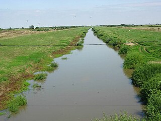
The Urluia is a right tributary of the Danube in Romania. Its length is 98 km (61 mi) and its basin size is 1,346 km2 (520 sq mi). It passes through Lake Vederoasa and flows into the Danube near Rasova. It flows along the villages Mereni, Miriștea, Osmancea, Ciobănița, Credința, Plopeni, Conacu, Negrești, Curcani, Petroșani, Șipotele, Zorile, Urluia, Aliman and Vlahii.

Žabljak Crnojevića is an abandoned medieval fortified town (fortress) in Montenegro. The fortress is located on the confluence of the Morača river in Lake Skadar.

The Moesian Limes or Limes Moesiae is the modern term given to a collection of Roman fortifications between the Black Sea shore and Pannonia, present-day Hungary, consisting primarily of forts along the Danube to protect the Roman provinces of Upper and Lower Moesia south of the river.

The Danube is Europe's second-longest river, after the Volga. It is located in Central and Eastern Europe.

The Jaleș is a left tributary of the river Tismana in Romania. It flows into the Tismana near Șomănești. Its length is 42 km (26 mi) and its basin size is 242 km2 (93 sq mi).
The First Battle of Cobadin, also known as the First Battle of the Rasova – Cobadin – Tuzla Line, was a battle fought from 17 to 19 of September 1916 between the Bulgarian Third Army and the Romanian–Russian Army of the Dobruja. The battle ended in Entente tactical victory and forced the Central Powers to hold their offensive and assume a defensive stance till the middle of October.

NMS Mihail Kogălniceanu was a monitor of the Romanian Navy. She saw service in both world wars, being the most successful vessel in her class of four ships. Like her three sisters, she was initially built as a river monitor, but in early 1918, she was converted to a sea-going monitor. During the Second Balkan war, she supported the Romanian crossing of the Danube into Bulgaria. During World War I, she carried out numerous bombardments against the Central Powers forces advancing along the shore of the Danube and carried out the last action of the Romanian Navy before the 11 November 1918 armistice. She later fought successfully against Bolshevik naval forces during the early months of the Russian Civil War, helping secure the Budjak region. During the interwar period, she contributed to the suppression of the Tatarbunary Uprising and was rearmed with longer main guns towards the end of the 1930s. During World War II, she fought several engagements against the Soviet Navy in the first month of the Eastern Front, but was ultimately sunk by Soviet aircraft shortly after Romania ceased hostilities against the Soviet Union, on 24 August 1944.
Rasova River may refer to:
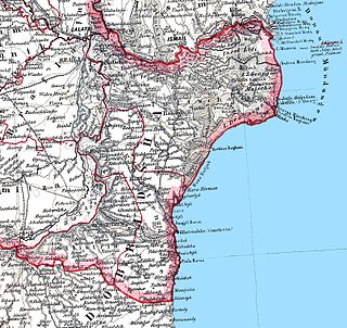
Silistra Nouă County was a county (județ) of Romania, in Northern Dobruja, with its capital city first at Rasova, later at Cernavodă and finally at Medgidia. It was established on 13 November 1878 and abolished on 1 April 1879. After this, it was integrated into Constanța County, which became the only county in Romanian Dobruja along with Tulcea County. Silistra Nouă County was composed of two plăși ("districts"): Plasa Medgidia and Plasa Silistra Nouă. Despite its name, it did not incude the city of Silistra.