| Ravine River | |
|---|---|
| Country | United States |
| Physical characteristics | |
| Main source | Baraga County, Michigan |
| River mouth | Baraga County, Michigan |
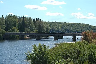
The Ravine River is a 16.2-mile-long (26.1 km) [1] stream on the Upper Peninsula of Michigan in the United States.

The Upper Peninsula (UP), also known as Upper Michigan, is the northern of the two major peninsulas that make up the U.S. state of Michigan. The peninsula is bounded on the north by Lake Superior, on the east by the St. Marys River, and on the southeast by Lake Michigan and Lake Huron. Geographically, the Upper Peninsula has a land boundary with Wisconsin, and over-water boundaries with Minnesota and Ontario (Canada). Upper Peninsula counties also include nearby islands such as Grand, Drummond, Mackinac, and Bois Blanc, and more distant Isle Royale.

Michigan is a state in the Great Lakes and Midwestern regions of the United States. The state's name, Michigan, originates from the Ojibwe word mishigamaa, meaning "large water" or "large lake". With a population of about 10 million, Michigan is the tenth most populous of the 50 United States, with the 11th most extensive total area, and is the largest state by total area east of the Mississippi River. Its capital is Lansing, and its largest city is Detroit. Metro Detroit is among the nation's most populous and largest metropolitan economies.

The United States of America (USA), commonly known as the United States or America, is a country comprising 50 states, a federal district, five major self-governing territories, and various possessions. At 3.8 million square miles, the United States is the world's third or fourth largest country by total area and is slightly smaller than the entire continent of Europe's 3.9 million square miles. With a population of over 327 million people, the U.S. is the third most populous country. The capital is Washington, D.C., and the largest city by population is New York City. Forty-eight states and the capital's federal district are contiguous in North America between Canada and Mexico. The State of Alaska is in the northwest corner of North America, bordered by Canada to the east and across the Bering Strait from Russia to the west. The State of Hawaii is an archipelago in the mid-Pacific Ocean. The U.S. territories are scattered about the Pacific Ocean and the Caribbean Sea, stretching across nine official time zones. The extremely diverse geography, climate, and wildlife of the United States make it one of the world's 17 megadiverse countries.
It rises in Baraga County near Mount Arvon at 46°44′50″N88°08′19″W / 46.74722°N 88.13861°W and flows initially northward and then westward into the Huron Bay of Lake Superior at 46°50′27″N88°15′07″W / 46.84083°N 88.25194°W . [2]

Baraga County is a county in the Upper Peninsula in the U.S. state of Michigan. As of the 2010 United States Census, the population was 8,860. The county seat is L'Anse. The county is named after Bishop Frederic Baraga, a Catholic missionary who ministered to indigenous peoples of the area during the period when Michigan was obtaining statehood.

Mount Arvon, elevation 1,979 feet (603 m), located in L'Anse Township, Baraga County, is the highest natural point in the U.S. state of Michigan. Like nearby Arvon Township, Mount Arvon takes its name from the deposits of slate in the area which were reminiscent of those around Caernarfon in Wales. Mount Arvon is part of the Huron Mountains. It rises about eight miles (13 km) south of Lake Superior. On the list of highest natural points in each U.S. state, Mount Arvon ranks 38th.

Huron Bay is a long, narrow fjord 12.3 miles (19.8 km) long, located in Baraga County, Michigan, on the northern shore of the Upper Peninsula of the State of Michigan. The bay, oriented in a northeast-southwest direction, is bounded by the Huron Mountains on its east and the Abbaye Peninsula on its west. This bay offers mariners entry into the interior of the Huron Mountains, the highest mountain range in Michigan. This bay is extremely narrow, being less than 1.0 mile (1.6 km) wide for most of its length, and it is one of the largest freshwater fjords in North America.


