Rawnsley's Bluff

Last updated
Annotated view of Rawnsley's Bluff from space Wilpenapoundfromspacewithnotes.jpg
Annotated view of Rawnsley's Bluff from space

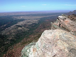
Rawnsley's Bluff is a geological feature in Australia. It is a bluff that is part of Wilpena Pound, and it is south of St Mary Peak (St Mary Peak is the tallest in the Flinders Ranges at 3,825 feet (1,166 meters)). [1] Rawnsley's Bluff connects the eastern and western mountain ranges of the pound. [1]

Australia Country in Oceania

Australia, officially the Commonwealth of Australia, is a sovereign country comprising the mainland of the Australian continent, the island of Tasmania and numerous smaller islands. It is the largest country in Oceania and the world's sixth-largest country by total area. The neighbouring countries are Papua New Guinea, Indonesia and East Timor to the north; the Solomon Islands and Vanuatu to the north-east; and New Zealand to the south-east. The population of 25 million is highly urbanised and heavily concentrated on the eastern seaboard. Australia's capital is Canberra, and its largest city is Sydney. The country's other major metropolitan areas are Melbourne, Brisbane, Perth and Adelaide.

Beach ridge Wave-swept or wave-deposited ridge running parallel to a shoreline

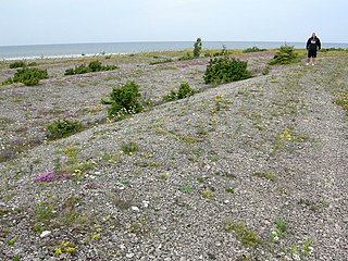
A beach ridge is a wave-swept or wave-deposited ridge running parallel to a shoreline. It is commonly composed of sand as well as sediment worked from underlying beach material. The movement of sediment by wave action is called littoral transport. Movement of material parallel to the shoreline is called longshore transport. Movement perpendicular to the shore is called on-offshore transport. A beach ridge may be capped by, or associated with, sand dunes. The height of a beach ridge is affected by wave size and energy.

Wilpena Pound natural amphitheatre of mountains located north of Adelaide, South Australia

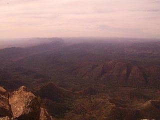
Wilpena Pound is a natural amphitheatre of mountains located 429 kilometres (267 mi) north of Adelaide, South Australia, Australia in the heart of the Flinders Ranges National Park. The Pound is accessed via a sealed road which continues on to the northern Flinders Ranges town of Blinman and to the south, Hawker.

The Adelaide Scotch College Cadet Unit used the bluff for training each year until the unit was disbanded in the early 1970s. [2] Training included flights with helicopters, infantry training, and practice with infantry weapons such as mortars. [2] The unit was noted for providing outdoor adventures to the student body. [2]

Scotch College, Adelaide secondary educational college in Adelaide, South Australia, Australia

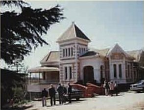
Scotch College is an independent, Uniting Church, co-educational, day and boarding school, located on two adjacent campuses in Torrens Park and Mitcham, inner-southern suburbs of Adelaide, South Australia.

Mortar (weapon) Artillery weapon that launches explosive projectiles at high angles

A mortar is usually a simple, lightweight, man portable, muzzle-loaded weapon, consisting of a smooth-bore metal tube fixed to a base plate with a lightweight bipod mount and a sight. They launch explosive shells in high-arcing ballistic trajectories. Mortars are typically used as indirect fire weapons for close fire support with a variety of ammunition.

In the 1890s Rawnsley's Bluff was home to a trigonometrical station, supporting surveying in South Australia. [3]

South Australia State of Australia

South Australia is a state in the southern central part of Australia. It covers some of the most arid parts of the country. With a total land area of 983,482 square kilometres (379,725 sq mi), it is the fourth-largest of Australia's states and territories by area, and fifth largest by population. It has a total of 1.7 million people, and its population is the second most highly centralised in Australia, after Western Australia, with more than 77 percent of South Australians living in the capital, Adelaide, or its environs. Other population centres in the state are relatively small; Mount Gambier, the second largest centre, has a population of 28,684.

Related Research Articles

Ikara-Flinders Ranges National Park Protected area in South Australia

The Ikara-Flinders Ranges National Park is situated approximately 400 km north of Adelaide in the northern central part of South Australia's largest mountain range, the Flinders Ranges. The park covers an area of 912 km², northeast of the small town of Hawker. The Heysen Trail and Mawson Trails pass through the park.

Lincoln National Park Protected area in South Australia

Lincoln National Park is a protected area in the Australian state of South Australia located about 249 kilometres (155 mi) west of the state capital of Adelaide and about 9.5 kilometres (5.9 mi) south of the municipal seat of Port Lincoln. It consists of a mainland area on the Jussieu Peninsula on the south eastern tip of Eyre Peninsula and a number of nearby islands. The national park contains significant sites of natural, indigenous and early European heritage.

Flinders Ranges mountain range in South Australia

The Flinders Ranges are the largest mountain range in South Australia, which starts about 200 km (125 mi) north of Adelaide. The discontinuous ranges stretch for over 430 km (265 mi) from Port Pirie to Lake Callabonna.

Vulkathunha-Gammon Ranges National Park Protected area in South Australia

The Vulkathunha-Gammon Ranges National Park is a protected area in the Australian state of South Australia located in the northern Flinders Ranges, immediately southwest of and adjacent to the Arkaroola Protection Area. They encompass some of the most rugged and spectacular country in South Australia.

Hawker, South Australia Suburb of Flinders Ranges Council, South Australia

Hawker is a town and a locality in the Flinders Ranges area of South Australia, 365 kilometres (227 mi) north of Adelaide. It is in the Flinders Ranges Council, the state Electoral district of Stuart and the federal Division of Grey. At the 2016 census, the locality had a population of 341 of which 237 lived in its town centre.

The Mawson Trail is a long-distance cycling trail in South Australia starting just east of Adelaide in the Adelaide Hills and extending almost 900 kilometres (560 mi) to Blinman in the Flinders Ranges. It is suitable for mountain bikes.

Blinman Town in South Australia

Blinman is a locality incorporating two towns located in the Australian state of South Australia within the Flinders Ranges about 425 kilometres (264 mi) north of the state capital of Adelaide. It is very small but has the claim of being the highest surveyed town in South Australia. It serves as a base for large acre pastoralists and tourism. The town is just north of the Flinders Ranges National Park, is 60 kilometres north of Wilpena Pound

Mount Chambers Gorge

Mount Chambers Gorge is a gorge in the Australian state of South Australia in the locality of Wertaloona about 60 kilometres (37 mi) north-east of Blinman in the Flinders Ranges.

St Mary Peak mountain in Australia

St Mary Peak is a mountain located in the Australian state of South Australia on the northwestern side of Wilpena Pound and is the highest peak in the Flinders Ranges with a height of 1,189 metres (3,901 ft). It is located within the Flinders Ranges National Park and the gazetted locality of Flinders Ranges, South Australia. St Mary Peak is the eighth highest peak in South Australia. Its former name "St Mary's Peak" remains in colloquial use.

Wilmington, South Australia Town in South Australia

Wilmington is a town and locality in the Yorke and Mid North region of South Australia.The town is located in the District Council of Mount Remarkable local government area, 305 kilometres (190 mi) north of the state capital, Adelaide. At the 2016 census, the locality had a population of 581 of which 419 lived in its town centre.

Mount Hill (South Australia) mountain in South Australia

Mount Hill is a prominent peak in the Australian state of South Australia on the eastern side of southern Eyre Peninsula. It is located within the locality of Butler.

Adelaide Bushwalkers is a bushwalking club based in Adelaide, South Australia.

Kanalla Falls

The Kanalla Falls, a waterfall on the Edeowie Creek, is located in the Flinders Ranges in South Australia.

Henry Strong Price, generally known as H.S. Price, or simply Harry Price, was a pioneer sheep pastoralist of South Australia, best known as founder and proprietor of Wilpena Station at Wilpena Pound, now part of the Ikara-Flinders Ranges National Park.

Flinders Ranges, South Australia Suburb of Flinders Ranges Council, South Australia

Flinders Ranges is a locality in the Australian state of South Australia located in the mountain range of the same name, about 380 kilometres north of the state capital of Adelaide, about 86 kilometres north-east of the municipal seat of Quorn and about 131 kilometres north-east of the centre of Port Augusta in the state’s Far North region.

Cazneaux Tree

The Cazneaux Tree, also known as Cazneaux's Tree, is a Eucalyptus camaldulensis or river red gum that was made famous by the photographer Harold Cazneaux. It is located in the Australian state of South Australia in the locality of Flinders Ranges near Wilpena Pound. The tree is located within the boundaries of the Ikara-Flinders Ranges National Park on the west side of the Flinders Ranges Way about 3 kilometres (1.9 mi) north-east of the Wilpena Pound Resort.

County of Taunton Cadastral in South Australia

County of Taunton is a cadastral unit located in the Australian state of South Australia on land on the east coast of Lake Torrens about 160 kilometres (99 mi) from the city of Port Augusta. It was proclaimed in 1877 and named after Lord Taunton who was the Secretary for the Colonies from 1855 to 1858. It has been partially divided in the following sub-units of hundreds – Bunyeroo, Carr, Edeowie, Nilpena, Oratunga and Parachilna.

County of Blachford Cadastral in South Australia

County of Blachford is a cadastral unit located in the Australian state of South Australia that covers land between the east coast of Lake Torrens and the western side of the Flinders Ranges about 90 kilometres (56 mi) north-east of the city of Port Augusta. It was proclaimed in 1877 and named after Frederic Rogers, 1st Baron Blachford who was the Under Secretary of State for the Colonies from 1860 to 1871. It has been partially divided in the following sub-units of hundreds – Barndioota, Cotabena, Warrakimbo, Wonoka and Woolyana.

County of Hanson Cadastral in South Australia

County of Hanson is a cadastral unit located in the Australian state of South Australia that covers land in the Flinders Ranges immediately east of the town of Hawker. It was proclaimed on 20 July 1877 and is named after Sir Richard Davies Hanson who served as Premier, Administrator and Chief Justice of South Australia. It has been partially divided in the following sub-units of hundreds – Adams, Arkaba, French, Moralana and Warcowie.

References