
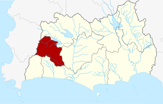
Rayong Province is a province (changwat) of Thailand. Neighboring provinces are Chonburi, and Chanthaburi. To the south is the Gulf of Thailand.

Chanthaburi is a town in the east of Thailand, on the banks of the Chanthaburi River. It is the capital of the Chanthaburi Province and the Mueang Chanthaburi District.
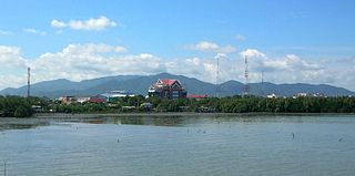
Rayong is a city on the east coast of the Gulf of Thailand and the capital of Rayong Province. It covers tambons Tha Pradu and Pak Nam and parts of tambons Choeng Noen and Noen Phra, all within Mueang Rayong District. As of 2016 the population was 64,256 (est.). The main industry is fishing, and it is also the main producer of Thailand's fish sauce. It is also the center of the chemical and auto industries. In 2012 Ford Motor Company opened an assembly plant in Rayong to expand Ford's presence in the ASEAN area, employing some 2,200 people.

U-Tapao International Airport also spelled Utapao and U-Taphao, is a joint civil–military public airport serving Rayong and Pattaya cities in Thailand. It is in Ban Chang District of Rayong Province. Its official name is "U-Tapao Rayong Pattaya International Airport".

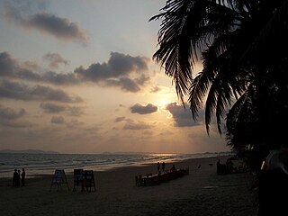
Ko Samet is one of the eastern seaboard islands of Thailand. It is in the Gulf of Thailand off the coastline of the Thai province of Rayong, approximately 220 kilometres (140 mi) southeast of Bangkok. Ko Samet is part of the Phe Subdistrict of the Amphoe Mueang Rayong, of Rayong Province. Ko Samet is the largest and westernmost of a cluster of islands not far from the coast. Ko Samet measures 6.8 kilometres (4.2 mi) from north to south. At its closest point to the mainland, the island is 2.6 kilometres (1.6 mi) south of mainland Rayong Province; however the actual travelling distance from the main commercial tourist pier in the town of Phe to the island's closest tourist beach is about 10 kilometres (6.2 mi).

Ban Chang is the westernmost district (amphoe) of Rayong Province, eastern Thailand.
Nikhom Phatthana is a district (amphoe) of Rayong Province, eastern Thailand.

Wang Chan is a district (amphoe) in the northern part of Rayong Province, eastern Thailand.

Mueang Rayong is the capital district of Rayong Province, Thailand. The provincial administration is in Tambon Map Ta Phut.

Klaeng District is a district (amphoe) on the coast of Rayong Province, eastern Thailand.

Ban Khai is a district (amphoe) in the central part of Rayong Province, eastern Thailand.
The Thai highway network follows the left-hand traffic rule of the road. The network is the twin responsibility of the Department of Highways, and the Department of Rural Roads, under the oversight of the Transportation ministry of Thailand. Public highways are also called public roads, especially when part of urban streets. The network spans over 70,000 kilometers across all regions of Thailand. Most are single carriageways. Dual carriageways have frequent u-turn lanes and intersections slowing down traffic. Coupled with the increase in the number of vehicles and the demand for a limited-access motorway, the Thai Government issued a Cabinet resolution in 1997 detailing the motorway construction master plan. Some upgraded sections of highway are being turned into a "motorway", while other motorways are not being built from highway sections.
Map Ta Phut is a town in Rayong Province, Thailand. It is the site of Thailand's largest industrial park, the Map Ta Phut Industrial Estate. Provincial offices are in Map Ta Phut.

Lat Krabang Station (สถานีลาดกระบัง) is an Airport Rail Link station on Thanon Rom Klao in Lat Krabang District, Eastern Bangkok.
Chonburi is the capital of Chonburi Province and Mueang Chonburi District in Thailand. It is about 100 km southeast of Bangkok, on the coast of the Gulf of Thailand. Its name means 'city of water'. Chonburi, along with other areas along the coast to Pattaya, forms a conurbation known as the Pattaya-Chonburi Metropolitan Area.
Pak Nam or Paknam is a Thai place name meaning river mouth. It may refer to:
The Don Mueang–Suvarnabhumi–U-Tapao high-speed railway, officially known as the High-Speed Rail Linking Three Airports Project is the second high-speed rail line project in Thailand, being due to open in 2023 between Don Mueang International Airport, Suvarnabhumi Airport and U-Tapao International Airport. It has been operated by Eastern High-Speed Rail Linking Three Airports Company Limited, a special-purpose vehicles by the consortium of Charoen Pokphand Holding and partners. Including Charoen Pokphand Holding (CP), Ch. Karnchang PLC. (CK), Bangkok Expressway and Metro PLC. (BEM), Italian-Thai Development PLC. (ITD) and China Railway Construction Corporation Limited (CRCC).
This page is based on this
Wikipedia article Text is available under the
CC BY-SA 4.0 license; additional terms may apply.
Images, videos and audio are available under their respective licenses.