
The Irvine Company LLC is an American private company focused on real estate development. It is headquartered in Newport Beach, California, with a large portion of its operations centered in and around Irvine, California, a planned city of more than 300,000 people mainly designed by the Irvine Company. The company was founded by the Irvine family and is currently wholly owned by Donald Bren.

Chino Hills State Park is a state park of California, in the United States. It is located in the Chino Hills, foothills of the Santa Ana Mountains. It is a critical link in the Chino–Puente Hills wildlife corridor, and a major botanical habitat reserve for resident and migrating wildlife.

The Santa Ana Mountains are a short peninsular mountain range along the coast of Southern California in the United States. They extend for approximately 61 miles (98 km) southeast of the Los Angeles Basin largely along the border between Orange and Riverside counties.
The Santa Ana Valley is located in Orange County, California and is bisected by the Santa Ana River. The valley is home to most of Orange County's central business districts. The cities of Anaheim, Buena Park, Costa Mesa, Fullerton, Irvine, Orange, Placentia, Santa Ana, and Yorba Linda are located in the Santa Ana Valley.

The recorded history of the Newport Beach, California region began when the area was first explored by Europeans in the 1500s. Prior to that time, Native Americans such as the Tongva and Juaneño/Luiseño people had been living in the area for thousands of years. Explorer Juan Rodriguez Cabrillo mapped the coastline in 1542, but it was 200 years before Europeans settled the area. In 1769, Newport was a small portion of the land grant of Don José Antonio Yorba I, first under Spanish and then Mexican rule. After the Civil War, the land was developed by American settlers: for ranching by James Irvine and for shipping by James McFadden. A small settlement was built around McFaddens’ Wharf and it became the largest business of Orange County, California. Following the opening of the San Pedro Harbor in Los Angeles in 1899, the commercial shipping industry in Newport declined. Newport Beach developed into a tourist and recreational boating community. in August 1906, Newport Beach became incorporated as a city.
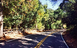
Silverado is an unincorporated community in Silverado Canyon, which is located in the Santa Ana Mountains in eastern Orange County, California. Portions of the town sit on a former Mexican land grant Rancho Lomas de Santiago. Silverado is located at the boundaries of Cleveland National Forest. The site is a California Historical Landmark, and is located near the village site of Puhú.
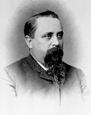
José Antonio Yorba, also known as Don José Antonio Yorba I, was a Spanish soldier and early settler of Spanish California.

Black Star Canyon is a remote mountain canyon in the Santa Ana Mountains, located in eastern Orange County, California. It is a watershed of the Santa Ana River. Black Star Canyon is a popular destination for mountain bikers as well as hikers due to its wild scenery. The California Historical Landmark associated with the canyon refers to the village of Puhú.
Rancho Santiago de Santa Ana was a 63,414-acre (256.63 km2) Spanish land concession in present-day Orange County, California, given by Spanish Alta California Governor José Joaquín de Arrillaga in 1810 to Jose Antonio Yorba and his nephew Pablo Peralta. The grant extended eastward from the Santa Ana River to the Santa Ana Mountains, with a length of more than 22 miles (35 km).

Santiago Creek is a major watercourse in Orange County in the U.S. state of California. About 34 miles (55 km) long, it drains most of the northern Santa Ana Mountains and is a tributary to the Santa Ana River. It is one of the longest watercourses entirely within the county. The creek shares its name with Santiago Peak, at 5,687 ft (1,733 m) the highest point in Orange County, on whose slopes its headwaters rise.
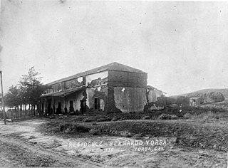
The Yorba Hacienda was a domestic dwelling constructed by Bernardo Yorba on the Rancho Cañón de Santa Ana Mexican land grant, and located in the present city of Yorba Linda, California. It was notable as the seat of the wealthiest member of the Yorba family and as the largest adobe hacienda in Alta California.

San Diego Creek is a 16-mile (26 km) urban waterway flowing into Upper Newport Bay in Orange County, California in the United States. Its watershed covers 112.2 square miles (291 km2) in parts of eight cities, including Irvine, Tustin, and Costa Mesa. From its headwaters in Laguna Woods the creek flows northwest to its confluence with Peters Canyon Wash, where it turns abruptly southwest towards the bay. Most of the creek has been converted to a concrete flood control channel, but it also provides important aquatic and riparian habitat along its course and its tidal estuary.

Rancho San Joaquin, the combined Rancho Cienega de las Ranas and Rancho Bolsa de San Joaquin, was a 48,803-acre (197.50 km2) Mexican land grant in the San Joaquin Hills, within present-day Orange County, California.
Rancho Lomas de Santiago was a 47,227-acre (191 km2) Mexican land grant given by Mexican Governor Pío Pico to Teodosio Yorba in 1846. The name means "Hills of St. James". The rancho included parts of present-day Irvine and Tustin in what is now eastern Orange County, California.

Rancho La Sierra was a 17,769-acre (71.91 km2) Mexican land grant in present-day Riverside County, California, United States. In 1846 governor Pio Pico issued the grant to Bernardo Yorba. The grant lay between Rancho Jurupa and Rancho El Rincon, and included the present-day city of Corona.
Rancho La Sierra was a 17,774-acre (71.93 km2) Mexican land grant in present-day Riverside County, California, United States. In 1846 Governor Pio Pico issued the grant to Vicenta Sepulveda. The rancho includes the present-day city of Norco, and the western end of Riverside.

Peters Canyon Regional Park is a regional park within the Orange County Regional Parks System in California. The park contains 354 acres of southern California wildlife, including coastal sage shrub, riparian, freshwater marsh, and grasslands, and is located within the boundaries of both Orange, California and Tustin, California. Peters Canyon was given to this city in 1992 by the Irvine Company who had used it previously for cattle grazing. The canyon is lined with a residential area on one side and open hills on the other. This canyon is commonly used by hikers, mountain bikers, and equestrians because of the trails that circumvent the 50 acre man-made lake, which was constructed by the Irvine Company in 1931, on the interior of the plot. The regional park is open from 7:00 AM to sunset every day of the week, save for the chance of rain or hazardous conditions, in which case the park will be closed for three days following the particular occurrence.
The Bixby land companies were a group of California-based land companies founded by various members of the Bixby and Flint families from Maine. In the late 19th and early 20th centuries, the firms of Flint, Bixby & Company, J. Bixby & Company, J. W. Bixby & Company, the Alamitos Land Company, and the Bixby Land Company controlled large swathes of California real estate, much of it derived from Mexican land grants. At various times their holdings included Rancho Los Cerritos, Rancho Los Alamitos, half of Rancho San Justo, and part of Rancho Palos Verdes together with other property in San Benito, Santa Barbara, and Los Angeles counties. Parts of the towns of Long Beach, Bellflower, Paramount, Signal Hill, Lakewood, and Los Alamitos emerged from former Bixby-held lands.
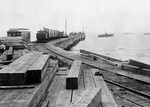
The place of McFadden Wharf was designated a California Historic Landmark (No.794) on July 3, 1964.
The Sepúlveda family is a prominent Californio family of Southern California. Members of the family held extensive rancho grants and numerous important positions, including Alcalde de Los Ángeles, California State Assemblymen, and Los Angeles County Supervisor.


