Coordinates: 50°57′25″N2°11′28″W / 50.957°N 2.191°W Redlane Hundred or Redland Hundred was a hundred in the county of Dorset, England, containing the following parishes:

A geographic coordinate system is a coordinate system that enables every location on Earth to be specified by a set of numbers, letters or symbols. The coordinates are often chosen such that one of the numbers represents a vertical position and two or three of the numbers represent a horizontal position; alternatively, a geographic position may be expressed in a combined three-dimensional Cartesian vector. A common choice of coordinates is latitude, longitude and elevation. To specify a location on a plane requires a map projection.

A county is a geographical region of a country used for administrative or other purposes, in certain modern nations. The term is derived from the Old French conté or cunté denoting a jurisdiction under the sovereignty of a count (earl) or a viscount. The modern French is comté, and its equivalents in other languages are contea, contado, comtat, condado, Grafschaft, graafschap, Gau, etc..

Dorset is a county in South West England on the English Channel coast. The ceremonial county comprises the unitary authority areas of Bournemouth, Christchurch and Poole and Dorset. Covering an area of 2,653 square kilometres (1,024 sq mi), Dorset borders Devon to the west, Somerset to the north-west, Wiltshire to the north-east, and Hampshire to the east. The county town is Dorchester which is in the south. After the reorganisation of local government in 1974 the county's border was extended eastward to incorporate the Hampshire towns of Bournemouth and Christchurch. Around half of the population lives in the South East Dorset conurbation, while the rest of the county is largely rural with a low population density.
- Buckhorn Weston
- Child Okeford
- East Stour
- Fifehead Magdalen
- Hanford (from 1858)
- Iwerne Courtney
- Kington Magna
- Manston
- Silton
- Sutton Waldron
- Todber
- West Stour
Buckhorn Weston is a village and civil parish in the English county of Dorset, situated in the Blackmore Vale in the North Dorset administrative district, about 3 miles (4.8 km) west of the town of Gillingham. It lies on the western edge of the former royal hunting ground of Gillingham Forest. The underlying geology is Oxford clay and Corallian limestone. In the 2011 census the civil parish had a population of 356.

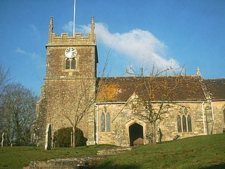
Child Okeford is a village and civil parish in the county of Dorset in southern England, situated 3 miles (4.8 km) east of the small town of Sturminster Newton in the North Dorset administrative district. Child Okeford lies downstream from Sturminster, along the River Stour, which passes half a mile west of the village. In the 2011 census the civil parish had a population of 1,114.

East Stour is a village and civil parish in the county of Dorset in southern England. It lies within the North Dorset administrative district, about 2 miles (3.2 km) south of the town of Gillingham. The village is sited half a mile from the east bank of the River Stour in the Blackmore Vale and two miles west of the broadly conical local landmark Duncliffe Hill. Above the west bank of the river, about a mile away, is the village of West Stour. The A30 London to Penzance road passes through the village. In the 2011 census the civil parish had a population of 573.