Humboldt Redwoods State Park is a state park of California, United States, containing Rockefeller Forest, the world's largest remaining contiguous old-growth forest of coast redwoods. It is located 30 miles (48 km) south of Eureka, California, near Weott in southern Humboldt County, within Northern California, named after the great nineteenth-century scientist, Alexander von Humboldt. The park was established by the Save the Redwoods League in 1921 largely from lands purchased from the Pacific Lumber Company. Beginning with the dedication of the Raynal Bolling Memorial Grove, it has grown to become the third-largest park in the California State Park system, now containing 51,651 acres (20,902 ha) through acquisitions and gifts to the state.

State Route 82 is a state highway in the U.S. state of California that runs from Interstate 880 (I-880) in San Jose to I-280 in San Francisco following the San Francisco Peninsula. It is the spinal arterial road of the peninsula and runs parallel to the nearby Caltrain line along much of the route. For much of its length, the highway is named El Camino Real and formed part of the historic El Camino Real mission trail. It passes through and near many the historic downtowns of many Peninsula cities, including Burlingame, San Mateo, Redwood City, Menlo Park, Palo Alto, Mountain View, and Sunnyvale, and through some of the most walkable and transit-oriented neighborhoods in the region.

State Route 116 is a state highway in the U.S. state of California in Sonoma County. The route runs from State Route 1 on the Pacific coast near Jenner to State Route 121 south of Sonoma.

State Route 283 is a state highway in the U.S. state of California. Unsigned along its entire length, SR 283 runs from U.S. Route 101 south of Rio Dell to the center of the city and back to U.S. Route 101. The route was defined in 1970 as a transfer from a realigned Route 101.

U.S. Route 101 (US 101), is a major north–south U.S. Highway in Oregon that runs through the state along the coastline near the Pacific Ocean. It runs from the California border, south of Brookings, to the Washington state line on the Columbia River, between Astoria, Oregon, and Megler, Washington.
Grizzly Creek Redwoods State Park is a state park of California, USA, harboring groves of coast redwoods in three separate units along the Van Duzen River. It is located 20 miles (32 km) south of Eureka, California, then another 17 miles (27 km) east of Fortuna on State Route 36. The small park was created by a donation from Owen R. Cheatham, founder of Georgia-Pacific Corporation, who wanted to preserve the stand of redwoods in perpetuity. Originally established in 1943, the park has grown to 430 acres (170 ha). Cheatham Grove, 4 miles (6.4 km) west of the main unit, was added to the park in 1983 due to efforts of the Save the Redwoods League.
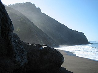
The Lost Coast is a mostly natural and undeveloped area of the California North Coast in Humboldt and Mendocino Counties, which includes the King Range. It was named the "Lost Coast" after the area experienced depopulation in the 1930s. In addition, the steepness and related geotechnical challenges of the coastal mountains made this stretch of coastline too costly for state highway or county road builders to establish routes through the area, leaving it the most undeveloped and remote portion of the California coast. Without any major highways, communities in the Lost Coast region such as Petrolia, Shelter Cove, and Whitethorn are isolated from the rest of California.

State Route 128 is a state highway in the U.S. state of California, connecting the Mendocino coast to the Sacramento Valley, through the state's Wine Country.

State Route 197 is a state highway in the U.S. state of California in Del Norte County near Crescent City. It is a bypass connecting U.S. Highways 199 and 101. It runs along the north bank of the Smith River.

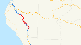
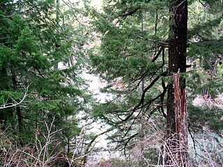
State Route 271 is a state highway in northern California, USA. It is a former routing of U.S. Route 101, now reduced to being a frontage road for that route in discontiguous segments. It also connects with Route 1 just before that route's terminus with US 101 in Leggett. Its appeal now is that while US Highway 101 stays mostly in second growth redwoods, State Route 271 travels through several old growth redwood groves. It is now most commonly used as a scenic alternate.
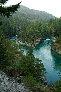
Smith River National Recreation Area is located northwestern California, United States. The Smith River National Recreation Area is in Six Rivers National Forest and is managed by the U.S. Forest Service, an agency of the U.S. Department of Agriculture. Created by Congress in 1990, Smith River National Recreation Area forms a northern border to Redwood National and State Parks.

The North Coast of California is the region in Northern California that lies on the Pacific coast between San Francisco Bay and the Oregon border. It commonly includes Mendocino, Humboldt, and Del Norte counties and sometimes includes two counties from the San Francisco Bay area, Marin and Sonoma.
Fernbridge is an unincorporated community at an elevation of 39 feet (12 m) in Humboldt County, California, named for a historic bridge, 3 miles (4.8 km) west-northwest of Fortuna.

Richardson Grove State Park is located at the southernmost border of Humboldt County, 75 miles (121 km) south of Eureka, California, United States, and 200 miles (320 km) north of San Francisco. The year-round park, which has approximately 2,000 acres (8.1 km2), straddles US 101, causing the narrowest point of its entire distance. Said to have the 9th largest tree of all remaining Coast Redwoods, it is known for swimming on the South Fork of the Eel River and day use in addition to 159 campsites.

Orick is a census-designated place situated on the banks of the Redwood Creek in Humboldt County, California. It is located 43 miles (69 km) north of Eureka, at an elevation of 26 feet. The population was 357 at the 2010 census.

Old Town refers to a portion of Downtown Novato. Old Town specifically refers to the downtown district on the East side of Redwood Boulevard which at one point was Highway 101, once called the Redwood Highway. Today Downtown Novato's main drag Grant Avenue, stretches across Redwood Boulevard but the term "Old Town" still refers to this portion of the downtown region most adjacent to the railroad depots.