
The Gran Paradiso or Grand Paradis is a mountain in the Graian Alps in Italy, located between the Aosta Valley and Piedmont regions. It is located in Gran Paradiso National Park.

Val-d'Isère, nicknamed Valdi, is a commune of the Tarentaise Valley, in the Savoie department in southeastern France. It lies 5 km (3 mi) from the border with Italy. It is on the border of the Vanoise National Park created in 1963, with good transport links in and out of Lyon, Geneva and Chambéry.

The French Alps are the portions of the Alps mountain range that stand within France, located in the Auvergne-Rhône-Alpes and Provence-Alpes-Côte d'Azur regions. While some of the ranges of the French Alps are entirely in France, others, such as the Mont Blanc massif, are shared with Switzerland and Italy.

The arrondissement of Albertville is an arrondissement of France in the Savoie department in the Auvergne-Rhône-Alpes region. It has 69 communes. Its population is 111,751 (2016), and its area is 2,466.1 km2 (952.2 sq mi).
Maurienne is one of the provinces of Savoy, corresponding to the arrondissement of Saint-Jean-de-Maurienne in France. It is also the original name of the capital of the province, now Saint-Jean-de-Maurienne.

Vanoise National Park is a French national park between the Tarentaise and Maurienne valleys in the French Alps, containing the Vanoise massif. It was created in 1963 as the first national park in France.
Massif des Cerces is a region of the French Alps on the Franco-Italian border. On the French side it lies in the departments of Hautes-Alpes and Savoie.

Modane is a commune in the Savoie department in the Auvergne-Rhône-Alpes region in southeastern France.

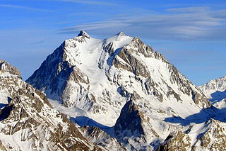
The Grande Casse is the highest mountain of the Vanoise Massif in the Graian Alps in the Savoie department, France. It is located in the heart of Vanoise National Park, near the village of Pralognan-la-Vanoise, which is about 25 km south-east of the nearest town, Moûtiers. It has a steep 600 m high north face. The other sides of the mountain are more gentle, mostly consisting of broken rocks. A high ridge connects it to the nearby peak of Grande Motte. The ridge connecting the Grande Casse and the Grande Motte is the watershed between the Tarentaise Valley in the north and Maurienne Valley to the south.
The Vanoise massif is a mountain range of the Graian Alps, located in the Western Alps. After the Mont Blanc Massif and the Écrins Massif it is the third-highest massif in France, reaching a height of 3,885 m at the summit of Grande Casse. It lies between Tarentaise Valley to the north and the Maurienne Valley in the south. The range is the site of France's first national park, established in 1963, Vanoise National Park. The ski resorts of Tignes and Val-d'Isère and the 2,770-metre-high Col de l'Iseran are located in the eastern part of the range.

Pralognan-la-Vanoise or simply Pralognan is an alpine commune in the Savoie department in the Auvergne-Rhône-Alpes region in Southeastern France. In 2019, it had a population of 715. The commune is located within Vanoise National Park.

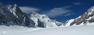
The Aiguille de la Vanoise is a mountain of Savoie, France. It lies in the Vanoise massif mountain range in the commune of Pralognan-la-Vanoise. It has an altitude of 2796 metres above sea level and is known for its great North Face which is 300 to 400m high.

The Tête Rousse Hut is a mountain hut in the Mont Blanc massif in the French Alps. It is located beside the Tête Rousse Glacier at an elevation of 3,167 m. Owned by the Club Alpin Francais (CAF), it is normally reached after an approximately two hour climb from Nid d'Aigle, the highest stop on the Mont Blanc Tramway. It is commonly used by mountaineers attempting to climb the 'normal route' on the French side to the summit of Mont Blanc. Staying here, rather than continuing to the higher Goûter Hut adds an extra 2–3 hours to the ascent of Mont Blanc, but is less cramped than the latter and also avoids having to climb the dangerous 'Grand Couloir' later in the day when the risk of injury from stonefall is at its greatest.
The Glacier Blanc is a glacier in the French département of Hautes-Alpes. Its name derives from the fact that – unlike the nearby Glacier Noir – its surface appears pristinely white due to an absence of morainic debris.
Patinoire olympique de Pralognan-la-Vanoise is a 2,300-seat indoor arena located in Pralognan-la-Vanoise, France. The venue hosted the curling competitions for the 1992 Winter Olympics in neighboring Albertville. It was then a demonstration sport.
The canton of Moûtiers is an administrative division of the Savoie department, southeastern France. Its borders were modified at the French canton reorganisation which came into effect in March 2015. Its seat is in Moûtiers.

The Goûter Hut, is a mountain refuge in the French department of Haute-Savoie. It is located at a height of 3,835 metres (12,582 ft) on the Arete du Goûter in the municipality of Saint-Gervais-les-Bains. It overlooks the Glacier de Bionnassay, and is the highest wardened mountain hut in France.

During the Second World War, the Oisans maquis was an important center for the French Resistance, in the Oisans region between the Belledonne range and Grenoble to the north, the Grandes Rousses massif of the Alps and the Croix de Fer pass to the east, the Drac valley to the west and the Barre des Écrins and the Provencal Alps to the south.

LaGrande Sure is a mountain in the French department of Isère, rising to an altitude of 1,920 meters in the Chartreuse mountain chain, in the Alps, overlooking the Pays Voironnais. Located on the western border of the mountain chain, it is composed of Fontanil limestone. It can be climbed from the eastern side via the Charmette mountain pass via the Grande Vache mountain pass, or from the Placette mountain pass via the western side, which is more strenuous and has a higher difficulty. This mountain is part of the Chartreuse Regional Nature Park as well as a natural zone of ecological, faunistic and floristic interest. The species of the chamois is particularly present in steep parts of the alpine tundra.
