Regarding the Fountain is an epistolary children's novel by Kate Klise published in 1998 and the first title in her Regarding the ... series set in Dry (Geyser) Creek, Missouri.
Through letters, memos, postcards, transcripts, documents, newspaper articles and telegraphs, Regarding the Fountain follows a class of fifth graders as they collaborate with a quirky fountain designer who has been hired to fix a leaky water fountain and in the process unexpectedly solve a local mystery.
The other titles in the series are Regarding the Sink (2004), Regarding the Trees (2005), and Regarding the Bathrooms (2006), and, most recently, Regarding the Bees (2007).
Plot summary
The novel, told through a series of letters, newspaper clippings, drawings, and other correspondences, tells the story of how Sam N.'s fifth grade class at Dry Creek Middle School under the guidance of a free-spirited fountain designer, Florence Waters, creates a unique fountain for their school, as the old one has a persistent leak. The students, which consist of Minnie O., Tad Poll, Gil, Shelly, and best friends Lily and Paddy, each attempt to aid Florence by coming up with their own increasingly eccentric designs, while Sam N. and principal Walter "Wally" Russ provide more practical ones. At the same time, through a series of zany mishaps, the group uncovers a scandal that will shock the entire town as the students discover what really happened the day the creek dried up.
It turns out that a long time ago, their hometown of Dry Creek was once known as Spring Creek, and had a free-flowing spring feeding their creek, until criminals Sally Mander and Delbert "Dee" Eel blocked off the water to feed their respective swimming pool and drinking water enterprises. In the present, it turns out that Mander and Eel's plan is going awry as the spring itself was fed by a geyser, which is currently about to erupt, and is also responsible for the fountain leak.
In the end, the town of Dry Creek, once known as Spring Creek, will be renamed Geyser Creek, and the criminals who diverted the town's waters for self serving purposes some years previous will be put behind bars. Florence installs the school's highly unusual new fountain, a combination of the best ideas sent by the locals.
Characters
Many of the characters in Regarding the Fountain (as well as the rest of the series) have names with water references or puns:
Flo Waters - fountain designer
Sam N. - teacher at Dry Creek Middle School
Wally Russ - principal of Dry Creek Middle School
Goldie Fisch - secretary of Dry Creek Middle School
Lily and Paddy and Tad Poll - fifth grade friends
Minnie O - best student in Sam N.'s class.
Sally Mander and Delbert "Dee" Eel - water stealing criminal masterminds
Related Research Articles
A geyser is a spring characterized by an intermittent discharge of water ejected turbulently and accompanied by steam. As a fairly rare phenomenon, the formation of geysers is due to particular hydrogeological conditions that exist only in a few places on Earth.
Macon County is a county located in the U.S. state of North Carolina. As of the 2020 census, the population was 37,014. Its county seat is Franklin.
The City of Fountain is a home rule municipality located in El Paso County, Colorado, United States. The population was 29,802 at the 2020 census. Fountain is a part of the Colorado Springs, CO Metropolitan Statistical Area and the Front Range Urban Corridor.
Hartsville is the largest city in Darlington County, South Carolina, United States. It was chartered on December 11, 1891. The population was 7,764 at the 2010 census. Hartsville was chosen as an All-America City in 1996 and again in 2016. Hartsville has also been a National Arbor Day Foundation Tree City since 1986.
Big Bend is a village in Waukesha County, Wisconsin, United States. The population was 1,483 at the 2020 census.
The geothermal areas of Yellowstone include several geyser basins in Yellowstone National Park as well as other geothermal features such as hot springs, mud pots, and fumaroles. The number of thermal features in Yellowstone is estimated at 10,000. A study that was completed in 2011 found that a total of 1,283 geysers have erupted in Yellowstone, 465 of which are active during an average year. These are distributed among nine geyser basins, with a few geysers found in smaller thermal areas throughout the Park. The number of geysers in each geyser basin are as follows: Upper Geyser Basin (410), Midway Geyser Basin (59), Lower Geyser Basin (283), Norris Geyser Basin (193), West Thumb Geyser Basin (84), Gibbon Geyser Basin (24), Lone Star Geyser Basin (21), Shoshone Geyser Basin (107), Heart Lake Geyser Basin (69), other areas (33). Although famous large geysers like Old Faithful are part of the total, most of Yellowstone's geysers are small, erupting to only a foot or two. The hydrothermal system that supplies the geysers with hot water sits within an ancient active caldera. Many of the thermal features in Yellowstone build up sinter, geyserite, or travertine deposits around and within them.
A spring is a natural exit point at which groundwater emerges out of the aquifer and flows onto the top of the Earth's crust (pedosphere) to become surface water. It is a component of the hydrosphere, as well as a part of the water cycle. Springs have long been important for humans as a source of fresh water, especially in arid regions which have relatively little annual rainfall.
A fountain, from the Latin "fons", meaning source or spring, is a decorative reservoir used for discharging water. It is also a structure that jets water into the air for a decorative or dramatic effect.
The River Dee is a river flowing through North Wales, and through Cheshire, England, in Great Britain. The length of the main section from Bala to Chester is 113 km and it is largely located in Wales. The stretch between Aldford and Chester is within England, and two other sections form the border between the two countries.
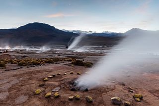
El Tatio is a geothermal field with many geysers located in the Andes Mountains of northern Chile at 4,320 metres (14,170 ft) above mean sea level. It is the third-largest geyser field in the world and the largest in the Southern Hemisphere. Various meanings have been proposed for the name "El Tatio", including "oven" or "grandfather". The geothermal field has many geysers, hot springs, and associated sinter deposits. These hot springs eventually form the Rio Salado, a major tributary of the Rio Loa, and are a major source of arsenic pollution in the river. The vents are sites of populations of extremophile microorganisms such as hyperthermophiles, and El Tatio has been studied as an analogue for the early Earth and possible past life on Mars.
Hot Springs National Park is an American national park in central Garland County, Arkansas, adjacent to the city of Hot Springs, the county seat. Hot Springs Reservation was initially created by an act of the United States Congress on April 20, 1832, to be preserved for future recreation. Established before the concept of a national park existed, it was the first time that land had been set aside by the federal government to preserve its use as an area for recreation. The hot spring water has been popularly believed for centuries to possess medicinal properties, and was a subject of legend among several Native American tribes. Following federal protection in 1832, the city developed into a successful spa town.
Steamboat Springs is a small volcanic field of rhyolitic lava domes and flows in western Nevada, located south of Reno. There is extensive geothermal activity in the area, including numerous hot springs, steam vents, and fumaroles. The residential portions of this area, located mostly east of Steamboat Creek and south of modern-day SR 341, are now known simply as Steamboat.
In landscape architecture and garden design, a water feature is one or more items from a range of fountains, jeux d'eau, pools, ponds, rills, artificial waterfalls, and streams. Before the 18th century they were usually powered by gravity, though the famous Hanging Gardens of Babylon are described by Strabo as supplied by an Archimedean screw and other examples were supplied with water using hydraulic rams.
Pine Creek is a tributary of Mahantango Creek in Schuylkill and Dauphin counties, Pennsylvania, in the United States. It is approximately 23.7 miles (38.1 km) long. The creek flows through Foster Township, Hegins Township, Hubley Township, and Upper Mahantango Township in Schuylkill County and Lykens Township in Dauphin County. The creek's watershed has an area of 76.8 square miles (199 km2) and its tributaries include Rausch Creek and Deep Creek. Pine Creek is considered by the Pennsylvania Department of Environmental Protection to be impaired by abandoned mine drainage and resource extraction. However, it is designated as a coldwater fishery.
The South Fork Eel River is the largest tributary of the Eel River in north-central California in the United States. The river flows 105 miles (169 km) north from Laytonville to Dyerville/Founders' Grove where it joins the Eel River. The South Fork drains a long and narrow portion of the Coast Range of California in parts of Mendocino and Humboldt counties. U.S. Route 101 follows the river for much of its length.
Cottonwood Creek is a major stream and tributary of the Sacramento River in Northern California. About 68 miles (109 km) long measured to its uppermost tributaries, the creek drains a large rural area bounded by the crest of the Coast Ranges, traversing the northwestern Sacramento Valley before emptying into the Sacramento River near the town of Cottonwood. It defines the boundary of Shasta and Tehama counties for its entire length. Because Cottonwood Creek is the largest undammed tributary of the Sacramento River, it is known for its Chinook salmon and steelhead runs.
Soborom is a group of hot springs with accompanying fumaroles and mud volcanoes in the Tibesti Mountains of Chad. Three dispersed groups of vents are active there, some of which are used as spas by the local population.
This page is based on this Wikipedia article Text is available under the CC BY-SA 4.0 license; additional terms may apply. Images, videos and audio are available under their respective licenses.