Renca | |
|---|---|
Municipality and village | |
 | |
| Country | |
| Province | San Luis Province |
| Time zone | UTC−3 (ART) |
Renca is a village and municipality in San Luis Province in central Argentina. [1]
Renca | |
|---|---|
Municipality and village | |
| | |
| Country | |
| Province | San Luis Province |
| Time zone | UTC−3 (ART) |
Renca is a village and municipality in San Luis Province in central Argentina. [1]

The Arctic Archipelago, also known as the Canadian Arctic Archipelago, is an archipelago lying to the north of the Canadian continental mainland, excluding Greenland and Iceland
This is a list of the extreme points of the United Kingdom: the points that are farther north, south, east or west than any other location. Traditionally the extent of the island of Great Britain has stretched "from Land's End to John o' Groats".
The Wisconsin Range is a major mountain range of the Horlick Mountains in Antarctica, comprising the Wisconsin Plateau and numerous glaciers, ridges and peaks bounded by the Reedy Glacier, Shimizu Ice Stream, Horlick Ice Stream and the interior ice plateau.

James Ross Island is a large island off the southeast side and near the northeastern extremity of the Antarctic Peninsula, from which it is separated by Prince Gustav Channel. Rising to 1,630 metres (5,350 ft), it is irregularly shaped and extends 40 nautical miles in a north–south direction.

Arani, Jarani is the capital of Arani Province and Arani Municipality located in Cochabamba Department in the center of Bolivia at an altitude of 9,400 ft. At the time of census 2001 it had 3,512 inhabitants.
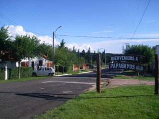
Papagayos is a village in Chacabuco Department, San Luis Province, Argentina. Among the small towns that are at the feet of the Comechingones Mountains, Papagayos stands out by its particular landscape of caranday palms.

Urdiales del Páramo is a municipality located in the province of León, Castile and León, Spain. According to the 2004 census (INE), the municipality has a population of 614 inhabitants.
Tanananifololahy or Tanonanifololahy is a town and commune in Madagascar. It belongs to the district of Andilamena, which is a part of Alaotra-Mangoro Region. The population of the commune was estimated to be approximately 5,000 in 2001 commune census.
Tar Hollow State Forest is a state forest in Hocking, Ross, and Vinton counties in the U.S. state of Ohio. It is part of an area of protected land that also includes Tar Hollow State Park.
Las Aguadas is a village and municipality in San Luis Province in central Argentina.
Luján is a village and municipality in San Luis Province in central Argentina.
Las Tejas is a village and municipality in Catamarca Province in northwestern Argentina.
On the continent of Antarctica, the Aramis Range is the third range south in the Prince Charles Mountains, situated 11 miles southeast of the Porthos Range and extending for about 30 miles in a southwest–northeast direction. It was first visited in January 1957 by Australian National Antarctic Research Expeditions (ANARE) southern party led by W.G. Bewsher, who named it for a character in Alexandre Dumas' novel The Three Musketeers, the most popular book read on the southern journey.

The borders of the oceans are the limits of Earth's oceanic waters. The definition and number of oceans can vary depending on the adopted criteria. The principal divisions of the five oceans are the Pacific Ocean, Atlantic Ocean, Indian Ocean, Southern (Antarctic) Ocean, and Arctic Ocean. Smaller regions of the oceans are called seas, gulfs, bays, straits, and other terms. Geologically, an ocean is an area of oceanic crust covered by water.
Bowman Inlet is an ice-filled inlet between Kay Nunatak and Platt Point on the Hollick-Kenyon Peninsula, on the east coast of the Antarctic Peninsula.

Widdowson Glacier is a glacier situated between Drummond and McCance Glaciers and flowing into Darbel Bay south of Sokol Point, on the west coast of Graham Land.

Funk Glacier is a glacier flowing into the head of Nevsha Cove in Beascochea Bay to the south of Frölich Peak, on the west coast of Graham Land, Antarctica. It was first charted by the French Antarctic Expedition, 1908–10, under Jean-Baptiste Charcot. It was named by the UK Antarctic Place-Names Committee in 1959 for Casimir Funk, an American biochemist who, while working at the Lister Institute in London in 1912, originated the theory of vitamins.

Dodman Island is an island in the Biscoe Islands, 6.5 km (4.0 mi) long, lying 7.4 km (4.6 mi) south-east of Rabot Island and 18.5 km (11.5 mi) west of Ferin Head, off the west coast of Graham Land, Antarctica. The island was charted and named by the British Graham Land Expedition, 1934–37, under John Rymill.

The Goodenough Glacier is a broad sweeping glacier to the south of the Batterbee Mountains, flowing from the west shore of Palmer Land, Antarctica, into George VI Sound and the George VI Ice Shelf.
| | This article about a place in San Luis Province, Argentina is a stub. You can help Wikipedia by expanding it. |