
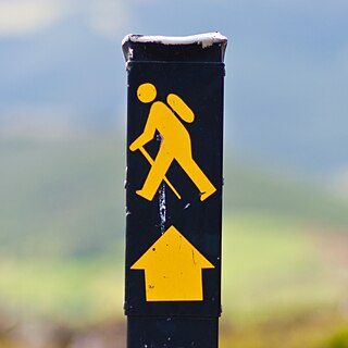
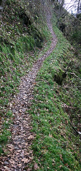
A trail, also known as a path or track, is an unpaved lane or small road usually passing through a natural area. In the United Kingdom and the Republic of Ireland, a path or footpath is the preferred term for a pedestrian or hiking trail. The term is also applied in North America to routes along rivers, and sometimes to highways. In the US, the term was historically used for a route into or through wild territory used by explorers and migrants. In the United States, "trace" is a synonym for trail, as in Natchez Trace.

The Thuringian Forest, is a mountain range in the southern parts of the German state of Thuringia, running northwest to southeast. Skirting from its southerly source in foothills to a gorge on its north-west side is the Werra valley. On the other side of the Forest is an upper outcrop of the North German Plain, the Thuringian Basin, which includes the city Erfurt. The south and south-east continuation of the range is the highland often called the Thuringian-Vogtlandian Slate Mountains.
These are lists of long-distance trails in the Republic of Ireland, and include recognised and maintained walking trails, pilgrim trails, cycling greenways, boardwalk-mountain trails, and interconnected national and international trail systems.

The Pennine Way is a National Trail in England, with a small section in Scotland. The trail stretches for 268 miles (431 km) from Edale, in the northern Derbyshire Peak District, north through the Yorkshire Dales and Northumberland National Park and ends at Kirk Yetholm, just inside the Scottish border. The path runs along the Pennine hills, sometimes described as the "backbone of England". Although not the United Kingdom's longest National Trail, it is according to The Ramblers "one of Britain's best known and toughest".
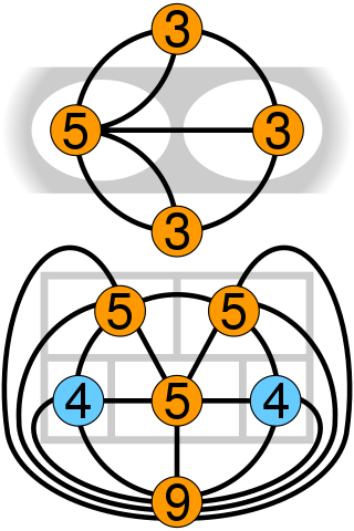
In graph theory, an Eulerian trail is a trail in a finite graph that visits every edge exactly once. Similarly, an Eulerian circuit or Eulerian cycle is an Eulerian trail that starts and ends on the same vertex. They were first discussed by Leonhard Euler while solving the famous Seven Bridges of Königsberg problem in 1736. The problem can be stated mathematically like this:

The National Cycle Network (NCN) was established to encourage cycling and walking throughout Britain, as well as for the purposes of bicycle touring. It was created by the charity Sustrans who were aided by a £42.5 million National Lottery grant. However Sustrans themselves only own around 2% of the paths on the network, these rest being made of existing public highways and rights of way, and permissive paths negotiated by Sustrans with private landowners, which Sustrans have then labelled as part of their network.

Historic roads are paths or routes that have historical importance due to their use over a period of time. Examples exist from prehistoric times until the early 20th century. They include ancient trackways, long-lasting roads, important trade routes, and migration trails. Many historic routes, such as the Silk Road, the Amber Road, and the Royal Road of the Persian Empire, covered great distances and their impact on human settlements remain today.

The Southern Upland Way is a 344-kilometre (214 mi) coast-to-coast long-distance footpath in southern Scotland. The route links Portpatrick in the west and Cockburnspath in the east via the hills of the Southern Uplands. The Way is designated as one of Scotland's Great Trails by NatureScot and is the longest of the 29 Great Trails. The Southern Upland Way meets with seven of the other Great Trails: the Annandale Way, the Berwickshire Coastal Path, the Borders Abbeys Way, the Cross Borders Drove Road, the Mull of Galloway Trail, the Romans and Reivers Route and St Cuthbert's Way.

The New Zealand Cycle Trail project is a New Zealand government initiative, co-funded together with local councils and charitable trusts, which is to build and operate a network of cycle routes through the country.

A long-distance trail is a longer recreational trail mainly through rural areas used for hiking, backpacking, cycling, horse riding or cross-country skiing. They exist on all continents except Antarctica.

The Rennsteig is a ridge walk as well as an historical boundary path in the Thuringian Forest, Thuringian Highland and Franconian Forest in Central Germany. The long-distance trail runs for about 170 km from Eisenach and the Werra valley in the northwest to Blankenstein and the Selbitz river in the southeast.

The Harz Witches' Trail is a footpath, just under 100 km long, in Germany that runs from Osterode through the Harz mountains and over its highest peak, the Brocken, to Thale. It is a project by the Harz Transport Association and Harz Club and is part of the system of trails known as the Harzer Wandernadel.

The Moray Coastal Trail is a long distance path in north-east Scotland that runs along the coastline of the Moray council area. The route, which is 72 km long, runs between Forres and Cullen. It is designated as one of Scotland's Great Trails by NatureScot, and connects with two further Great Trails: the Speyside Way at Spey Bay, and the Dava Way at Forres. The Moray Coast Trail can be combined with sections of these two routes to form a 153 km circular route known as the Moray Way, and also forms part of the North Sea Trail. The trail is primarily intended for walkers, but many sections are also suitable for cycling and horseriding. An alternative route for cycling, the Moray Coast Ride, shares some sections of path with the Moray Coast Trail, and forms part of the National Cycle Network's Route 1. About 23,000 people use the path every year, of whom about 1,000 complete the entire route.

The Dava Way is a 38-kilometre (24 mi) long-distance path that mostly follows the route of the former Highland Railway between Grantown and Forres. The railway line, built as a route between Inverness and Perth, opened in 1863 and closed in 1965. The route was reopened as a long distance path in 2005. It is listed as one of Scotland's Great Trails by NatureScot, and links directly to two further Great Trails: the Moray Coast Trail and the Speyside Way. It is currently the shortest of the Great Trails, but can be combined with sections of the Moray Coast Trail and Speyside Way to form a 153-kilometre (95 mi) circular route known as the Moray Way. About 3,000 people use the path every year, of whom about 400 complete the entire route.
The Tauber Valley Cycleway, official name in German: Liebliches Taubertal , in English Lovely Tauber Valley , also Charming Tauber Valley , is a German bicycle path running about 101 km along the River Tauber in Franconia, Germany. The cycleway runs from Rothenburg ob der Tauber via Bad Mergentheim and Tauberbischofsheim to Wertheim at the confluence of the Tauber and the Main. The path runs along its whole length through the valley of the Tauber and has only gentle ascents. At both ends and along the route there are railway stations. The General German Bicycle Club (ADFC) rated the trail five stars in 2009, the second path in Germany to receive this award after Main Cycleway.
The Ahr Cycleway is a cycle path, that runs from the source of the River Ahr in Blankenheim, in the Eifel region of Germany, along the river to its mouth on the Rhine near Kripp. Several sections are on an old railway trackbed. The route starts in the middle of the Eifel mountains and runs initially through a valley landscape with broad river bends. From the hamlet of Schuld the Ahr Valley narrows and swings around the settlement in a loop. In Altenahr, hillsides and rocks come close to the river itself and offer the best conditions for the wine growing. Behind the spa town of Bad Neuenahr-Ahrweiler the Ahr reaches its broad delta on the Rhine. The cycleway is not difficult and suitable for leisure cyclists. The route is uniformly signed with the cycleway's logo.

National Cycle Network (NCN) Route 65 is a Sustrans National Route that runs from Hornsea on the North Sea Coast of The East Riding of Yorkshire via Hull and York to Middlesbrough. It is fully open and signed.
A steig is a German term meaning "steep path" that originally referred to a narrow footpath over hills or mountains that could not be negotiated by horse-drawn vehicles. Today the term occurs in German-speaking countries as a synonym for all kinds of footpaths, e.g., Bürgersteig, a term for "pavement" in Austria or Switzerland. The term steig and its dialectical variations is commonly found in many placenames.