
The Rhine is one of the major European rivers, and has its sources in Switzerland and flows in a mostly northerly direction through Germany and the Netherlands, emptying into the North Sea. The river begins in the Swiss canton of Graubünden in the southeastern Swiss Alps, forms part of the Swiss-Liechtenstein, Swiss-Austrian, Swiss-German and then the Franco-German border, then flows through the German Rhineland and the Netherlands and eventually empties into the North Sea.

The geography of Switzerland encompasses the geographical features of Switzerland, a mountainous and landlocked country located in Western and Central Europe. Switzerland's natural landscape is marked by its numerous lakes and mountains. It is surrounded by 5 countries: Austria and Liechtenstein to the east, France to the west, Italy to the south and Germany to the north. Switzerland has a maximum north–south length of 220 kilometres (140 mi) and an east–west length of about 350 kilometres (220 mi).

The Lepontine Alps are a mountain range in the north-western part of the Alps. They are located in Switzerland and Italy.
The Alpine region of Switzerland, conventionally referred to as the Swiss Alps, represents a major natural feature of the country and is, along with the Swiss Plateau and the Swiss portion of the Jura Mountains, one of its three main physiographic regions. The Swiss Alps extend over both the Western Alps and the Eastern Alps, encompassing an area sometimes called Central Alps. While the northern ranges from the Bernese Alps to the Appenzell Alps are entirely in Switzerland, the southern ranges from the Mont Blanc massif to the Bernina massif are shared with other countries such as France, Italy, Austria and Liechtenstein.

The Grisons, Graubünden or Grigioni, more formally the Canton of the Grisons or the Canton of Graubünden, is one of the twenty-six cantons of Switzerland. It has eleven regions, and its capital is Chur. The German name of the canton, Graubünden, translates as the "Grey Leagues", referring to the canton's origin in three local alliances, the Three Leagues. The other native names also refer to the Grey League. The Alpine ibex is the canton's heraldic symbol.

The Alpine Rhine Valley is a glacial alpine valley, formed by the part of the Alpine Rhine between the confluence of the Anterior Rhine and Posterior Rhine at Reichenau and the Alpine Rhine's mouth at Lake Constance. It covers three countries and the full length of the Alpine Rhine is 93.5 km.
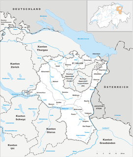
The canton of St. Gallen, also canton of St Gall, is a canton of Switzerland. The capital is St. Gallen.

Eastern Alps is the name given to the eastern half of the Alps, usually defined as the area east of a line from Lake Constance and the Alpine Rhine valley up to the Splügen Pass at the Alpine divide and down the Liro River to Lake Como in the south. The peaks and mountain passes are lower than the Western Alps, while the range itself is broader and less arched.

Rhine Valley is the valley, or any section of it, of the river Rhine in Europe.

Vogtei Rheintal was a condominium of the Old Swiss Confederacy from the 15th century until 1798. Its territory corresponded to the left banks of the Alpine Rhine between Hoher Kasten and Lake Constance, including the towns of Altstätten and Rheineck.
The Rheintaler Höhenweg, or Rhine valley high path, is a hiking trail along the western side of the Rhine valley in Switzerland. It starts in Rorschach on the edge of Lake Constance, and follows the Rhine river southwards (upstream) through wine fields, fruit orchards and cheese-making countryside to finish in Sargans. The total route covers around 100 km (62 mi), and reaches a maximum altitude of 1430 m (4700 feet).

The Alter Rhein is the old river bed of the Alpine Rhine in St. Gallen and Vorarlberg in the Alpine Rhine Valley, which was cut off when the Rhine was straightened during the 20th century. These cut-off arms have become valuable recreational areas and a nature reserve.
The Saar is a minor tributary of the Alpine Rhine in the Swiss canton of St. Gallen. It rises in Mittelsäss, Bad Ragaz municipality, at 2,087 m elevation. Flowing generally north, it passes the Saarfall waterfall, dropping from 560 m to 500 m, reaching the plain of the Rhine Valley. From here, it is strongly canalised, flowing through the territories of the Vilters-Wangs, Mels and Sargans municipalities before joining the Rhine downstream of Trübbach at 480 m.

The Rheintal/Walgau Autobahn (A14) is a motorway in the Austrian state of Vorarlberg.
The Vorarlberg Rhine Valley, also called the Vorarlberg Oberland and Unterland, is a section of the Alpine Rhine Valley and is divided into the Upper and Lower Rhine Valley based on the direction of flow of the river. The Unterland runs from the shore of Lake Constance to the Kummenberg, the Upper Rhine valley lies south of the Kummenberg. The Unterland covers the whole of the administrative district of Dornbirn and all the territories of the district of Bregenz that lie within the Rhine Valley. In this region, which includes the urban areas of Bregenz and Dornbirn, live about 180,000 people, around half the population of Vorarlberg. The "green lung" of this region is the Vorarlberg Ried, which is on the border with Switzerland and is surrounded by the settlements of Vorarlberg on three sides.

The Chur Rhine Valley is that part of Nordbünden through which the Rhine flows from the confluence of Anterior and Posterior Rhine near Reichenau to the cantonal border near Maienfeld and Fläsch. The plain of Bonaduz and Rhäzüns also belongs to the Chur Rhine Valley and forms its southern end. The valley is part of the Alpine Rhine natural landscape.

Rheintaler Ribelmais, Rheintaler Ribel or Türggenribel is a ground product that is made from a traditional type of maize grown in the Swiss Rhine Valley and Liechtenstein. Since summer 2000, Rheintaler Ribel AOP has been the only Swiss cereal product with a protected geographical indication. The name Ribelmais comes from the traditional dish, Ribel, from which it is made.

The Chur–Rorschach railway, also called the Rheintallinie, is a standard gauge railway line in Switzerland. It belongs to the Swiss Federal Railways (SBB) and is located in the cantons of St. Gallen and the Grisons.
The Rhine delta of Lake Constance is the river delta on the southeastern shore of Lake Constance, which the Rhine has formed in a former sea area. It lies mostly in the Austrian province of Vorarlberg, smaller areas are in the Swiss canton of St. Gallen. The two peninsulas in the lake are called Rheinspitz (west) and Rohrspitz (east).