Related Research Articles
Pennington County is a county in the U.S. state of South Dakota. As of the 2020 census, the population was 109,222, making it the second-most populous county in South Dakota. Its county seat is Rapid City. The county was created in 1875, and was organized in 1877. It is named for John L. Pennington, fifth Governor of Dakota Territory, who held office in 1875 when the county was formed.

Lawrence County is a county in the U.S. state of South Dakota. As of the 2020 census, the population was 25,768. Its county seat is Deadwood.

Lake Montezuma is a census-designated place (CDP) in Yavapai County in the U.S. state of Arizona. The population was 5,111 at the 2020 census. The CDP includes the communities of Rimrock and McGuireville. Located along Interstate 17, it is 20 miles (32 km) south of Sedona and 8 miles (13 km) north of Camp Verde in central Arizona's Verde Valley.

Spearfish is a city in Lawrence County, South Dakota. The population was 12,193 at the time of the 2020 census, making it the 10th most populous city in South Dakota.
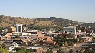
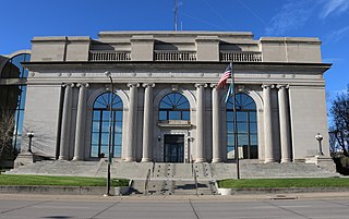
Rapid City is the second most populous city in South Dakota after Sioux Falls and the county seat of Pennington County. Named after Rapid Creek, where the settlement developed, it is in western South Dakota, on the Black Hills' eastern slope. The population was 74,703 as of the 2020 Census.
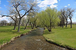
Rapid Creek is a tributary of the Cheyenne River, approximately 86 mi (138 km) long, in South Dakota in the United States. The creek's name comes from the Sioux Indians of the area, for the many rapids in the stream.
Castle Creek is a tributary of Rapid Creek, approximately 14 mi (23 km) long, in western South Dakota in the United States.

Rockerville is a small unincorporated community in Pennington County in the Black Hills of the U.S. state of South Dakota. Originally established as a mining camp, it was named for the "rockers" which were used to separate placer gold from stream gravel.
Johnson Siding is an unincorporated community in Pennington County, South Dakota, United States. The population as of the 2020 census was 614. It is located in the Rimrock Area, approximately 10 miles west of Rapid City. Johnson Siding is surrounded by the Black Hills National Forest. It is the only significant business district in the Rimrock Area, with a gas station/general store, deli, casino, tavern, the Johnson Siding Volunteer Fire Department firehouse, the Rimrock Evangelical Free Church meetinghouse, and a community center. However, most inhabitants work in Rapid City or Deadwood.

South Dakota is a state located in the north-central United States. It is usually considered to be in the Midwestern region of the country. The state can generally be divided into three geographic regions: eastern South Dakota, western South Dakota, and the Black Hills. Eastern South Dakota is lower in elevation and higher in precipitation than the western part of the state, and the Black Hills are a low, isolated mountain group in the southwestern corner of the state. Smaller sub-regions in the state include the Coteau des Prairies, Missouri Coteau, James River Valley, and the Dissected Till Plains. Geologic formations in South Dakota range in age from two billion-year-old Precambrian granite in the Black Hills to glacial till deposited over the last few million years. South Dakota is the 17th-largest state in the country.
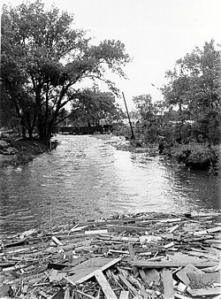
The Black Hills Flood of 1972, also known as the Rapid City Flood, was the most detrimental flood in South Dakota history, and one of the deadliest floods in U.S. history. The flood took place on June 9–10, 1972 in the Black Hills of Western South Dakota. 15 inches (380 mm) of rain in a small area over the Black Hills caused Rapid Creek and other waterways to overflow. Severe flooding of residential and commercial properties in Rapid City occurred when Canyon Lake Dam became clogged with debris and failed in the late evening hours of June 9 resulting in 238 deaths and 3,057 injuries. Over 1,335 homes and 5,000 automobiles were destroyed. The value of property damage was estimated to be over US$160 million in 1972 dollars. Flooding also occurred in Battle, Spring, Bear Butte, and Boxelder creeks.

Spearfish Canyon is a deep but narrow gorge carved by Spearfish Creek located in Lawrence County, South Dakota, U.S., just south of Spearfish. The canyon is located within the Black Hills, located on the northern edge of the Black Hills National Forest. The Spearfish Canyon Scenic Byway travels through the Canyon from Spearfish to Cheyenne Crossing along U.S. Route 14A. The highway follows an old railroad grade that was abandoned after massive flooding in 1933.

The Black Hills is an isolated mountain range rising from the Great Plains of North America in western South Dakota and extending into Wyoming, United States. Black Elk Peak, which rises to 7,244 feet (2,208 m), is the range's highest summit. The Black Hills encompass the Black Hills National Forest. The name of the hills in Lakota is Pahá Sápa. The Black Hills are considered a holy site. The hills are so called because of their dark appearance from a distance, as they are covered in evergreen trees.
Carbonate, also known as Carbonate Camp, West Virginia, Virginia, and Carbonate City (1881-1939), is a ghost town located in Lawrence County, South Dakota, United States.
Flatiron, formerly known as Yellow Creek or Flat Iron City, is a ghost town in Lawrence County, South Dakota, United States. It was known for its highly successful gold mining.
Pactola, also known as Camp Crook, (1875–1950s) is a ghost town in Pennington County, South Dakota, United States. It was an early placer mining town and existed into the early 1950s, when it was submerged under Pactola Lake.
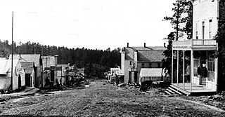
Rochford is an unincorporated community in Pennington County, South Dakota, United States. It is not tracked by the U.S. Census Bureau.
Roubaix, formerly known as Perry or Lewisville, is an unincorporated community in Lawrence County, South Dakota, United States. It is not monitored by the U.S. Census Bureau.
The Rapid City, Black Hills and Western Railroad, also known simply as the Black Hills and Western Railroad and commonly referred to as the Rapid Canyon Line or the Crouch Line, is a defunct standard gauge freight railroad line that operated in the Black Hills in the U.S. state of South Dakota. The railroad became known throughout the area for its crookedness and later became a tourist attraction. It ran from Rapid City to Mystic for a distance of 36.043 miles. The railroad ceased operations in 1947.
Redfern is the site of an old Black Hills Gold Rush community. The area is located at the eastern base of Redfern Mountain, 6,076 feet in elevation, in Pennington County, South Dakota. The mountain and the Redfern townsite is located on the gravel road to Mystic, South Dakota, and is about a mile from the old town site of Tigerville. The Mystic Road is approximately miles from Hill City on the Deerfield Road.
References
- U.S. Geological Survey Geographic Names Information System: Johnson Siding
- "Rimrock Community Center". Geographic Names Information System. United States Geological Survey. Retrieved 2012-09-23.