
The Ringberghaus (German for: Ringberg house), also often called Ringberghotel is a hotel east of the German city Suhl. In the 1970s, it was one of the most controversially discussed new buildings in the Suhl area.
The Ringberghaus (German for: Ringberg house), also often called Ringberghotel is a hotel east of the German city Suhl. In the 1970s, it was one of the most controversially discussed new buildings in the Suhl area.
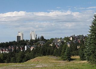
The Ringberghaus is built atop the 746 m high Ringberg, giving the hotel a very exposed location with high visibility. Suhl and Suhl-Goldlauter are located directly below the Ringberg, and the hotel can be seen from many vantage points of the Thuringian Forest, such as the "Plänckners Aussicht" at the Großer Beerberg, the Großer Hermannsberg or the Gebrannter Stein mountains.
The Ringberghaus was originally erected by the VdgB, an East German farmers' association. The building was opened in 1979 to provide farmers from rural areas of the GDR with affordable accommodation for holidays in the Thuringian Forest. Therefore, the Ringberghaus could only be booked with a special VdgB-issued voucher. After German reunification, operation of the hotel was taken over by several private enterprises, and the hotel belonged to the Holiday Inn chain for a brief time in the 1990s. Since 1997, the Ringberghaus is operated by the company RHB Ringberg Hotel Betriebsgesellschaft mbH.
When the Ringberghaus was built, the top of the Ringberg mountain had to be levelled to make room for the construction. Most of the excavated material was dumped one kilometre north of the hotel near the Simson lodge. Due to this massive impact on the mountain itself and the fact that the excavated material was filled in near a popular hiking lodge, the construction of the hotel was criticised heavily, even for standards of the GDR.
The current hotel in the Ringberghaus (Ringberghotel) was a member of the Ringhotels cooperation from November 2003 until December 2006. Since January 1, 2007, the hotel is independently operated. The hotel currently has 290 rooms on 6 floors with more than 160,000 stays per year. It is one of the largest hotels in the area and an important economic factor to the region. Due to its extraordinary location, the hotel is well received by hikers and families.
It also sees usage as a convention center. Between 2007 and 2009 it hosted Eurofurence. In 2008 the management of Ringberghaus invited Eurofurence to celebrate the 2008/2009 New Years celebrations in the theme of "Circus Ringberg." This continued for 2009/2010 (the last year of Eurofurence at Ringberghaus) and 2010/2011 (where costumed/fursuited members of Eurofurence were presented as aliens).

Thuringia, officially the Free State of Thuringia, is one of Germany's 16 states. With 2.1 million people, it is 12th-largest by population, and with 16,171 square kilometers, it is 11th-largest in area.

Vorarlberg is the westernmost state of Austria. It has the second-smallest geographical area after Vienna and, although it also has the second-smallest population, it is the state with the second-highest population density. Two thirds of the state are situated above 1,000m. It borders three countries: Germany, Switzerland, and Liechtenstein. The only Austrian state that shares a border with Vorarlberg is Tyrol, to the east.

The Thuringian Forest is a mountain range in the southern parts of the German state of Thuringia, running northwest to southeast. Skirting from its southerly source in foothills to a gorge on its north-west side is the Werra valley. On the other side of the Forest is an upper outcrop of the North German Plain, the Thuringian Basin, which includes the city Erfurt. The south and south-east continuation of the range is the highland often called the Thuringian-Vogtlandian Slate Mountains.
Ilm-Kreis is a district in Thuringia, Germany. It is bounded by the city of Erfurt, the districts of Weimarer Land, Saalfeld-Rudolstadt and Hildburghausen, the city of Suhl, and the districts of Schmalkalden-Meiningen and Gotha. It is named after the river Ilm, flowing through the district.

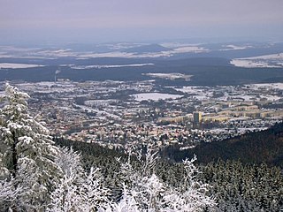
Suhl is a city in Thuringia, Germany, located SW of Erfurt, 110 kilometres NE of Würzburg and 130 kilometres N of Nuremberg. With its 37,000 inhabitants, it is the smallest of the six urban districts within Thuringia. Together with its northern neighbour-town Zella-Mehlis, Suhl forms the largest urban area in the Thuringian Forest with a population of 46,000. The region around Suhl is marked by up to 1,000-meter-high mountains, including Thuringia's highest peak, the Großer Beerberg, approximately 5 kilometres NE of the city centre.
Schmalkalden-Meiningen is a Landkreis in the southwest of Thuringia, Germany. Its neighboring districts are the districts Wartburgkreis, Gotha, Ilm-Kreis, the district-free city Suhl, the district Hildburghausen, the Bavarian district Rhön-Grabfeld, and the district Fulda in Hesse.

Mount San Antonio, commonly referred to as Mount Baldy or Old Baldy, is a 10,064 ft (3,068 m) summit in the San Gabriel Mountains on the border of Los Angeles and San Bernardino counties of California. Lying within the San Gabriel Mountains National Monument and Angeles National Forest, it is the highest point within the mountain range, the County of Los Angeles, and the Los Angeles metropolitan area.

A mountain hut is a building located at high elevation, in mountainous terrain, generally accessible only by foot, intended to provide food and shelter to mountaineers, climbers and hikers. Mountain huts are usually operated by an Alpine Club or some organization dedicated to hiking or mountain recreation. They are known by many names, including alpine hut, mountain shelter, mountain refuge, mountain lodge, and mountain hostel. It may also be called a refuge hut, although these occur in lowland areas too.
Oberhof is a town in the Schmalkalden-Meiningen district of Thuringia, Germany. Located in the Thuringian Forest mountain range, it is a winter sports center and health resort. With 1,625 inhabitants, it is visited by 144,000 tourists every year (2016). The town obtained its official city status in 1985.

The Schauinsland is a mountain in the Black Forest with an elevation of 1,284 m (4,213 ft) above sea level. It is a popular destination for day trips. Due to the high amount of silver mining, it was previously known as "Erzkasten" ; the name "Schouwesland" first appeared in 1347. The mountain is located roughly ten kilometres south-east of Freiburg's city centre.
Ilmenau is a town in Thuringia, central Germany. It is the largest town within the Ilm district with a population of 38,600, while the district capital is Arnstadt. Ilmenau is located approximately 33 km south of Erfurt and 135 km north of Nuremberg within the Ilm valley at the northern edge of the Thuringian Forest at an elevation of 500 metres.

Schloss Ringberg is located in the Bavarian Alps, 50 km south of Munich, on a foothill overlooking the Tegernsee. Not open to the general public, it is a property of the Max Planck Society and used for conferences.

Binz is the largest seaside resort city on the German island of Rügen.

The Rennsteig is a ridge walk as well as a historical boundary path in the Thuringian Forest, Thuringian Highland and Franconian Forest in Central Germany. The long-distance trail runs for about 170 km from Eisenach and the Werra valley in the northwest to Blankenstein and the Selbitz river in the southeast.
The Peasants Mutual Aid Association was an East German mass organization for peasants and farmers, later also gardeners. It was founded in the 1945–1946 period and was a participant in the National Front. From 1950 to 1963 and again in 1986, it had representation in the Volkskammer.
The Little Thuringian Forest is a region of mountains and hills that lies southwest of Suhl and northwest of Schleusingen, and extends as far as an imaginary line from Schmeheim via Bischofrod and Gethles to Rappelsdorf. Its length is about 11 km (6.8 mi), its width varies between 1 km (0.62 mi) and 2 km (1.2 mi). Its name is not to be understood in an orographic or geographic sense, but is due to the marked similarity of its bedrock to that of the Thuringian Forest to the north of it.

The Großer Finsterberg is a mountain, 944.1 m above NHN, in the Thuringian Forest not far from the villages of Stützerbach and Schmiedefeld am Rennsteig. It is the third highest peak in the German state of Thuringia.
Kickelhahn is a mountain in the northern edge of the Central Thuringian Forest in the municipal area of Ilmenau, Germany. Its summit has an altitude of 861.1 metres (2,825 ft) a.s.l.

The Plaue–Themar railway is a 62 kilometre-long, single-track, non-electrified, standard-gauge branch-line in the Thuringian Forest in Germany. The Stützerbach–Schleusingerneundorf section was built as the first Prussian rack railway between 1879 and 1904 and connects the Erfurt–Schweinfurt railway in the north via the towns of Plaue, Ilmenau, Schleusingen and Themar with the Eisenach–Lichtenfels railway in the south.

The Großer Hermannsberg is a mountain, 867 metres high, south of the main ridge of the Thuringian Forest in the county of Schmalkalden-Meiningen in Germany.