
Council Bluffs is a city in and the county seat of Pottawattamie County, Iowa, United States. The city is the most populous in Southwest Iowa, and forms part of the Omaha (Nebr.) Metropolitan Area. It is located on the east bank of the Missouri River, across from the city of Omaha. Council Bluffs was known, until at least 1853, as Kanesville. It was the historic starting point of the Mormon Trail. Kanesville is also the northernmost anchor town of the other emigrant trails, since there was a steam powered boat to ferry their wagons, and cattle, across the Missouri River.

Butler County is a county located in the southeast Ozark Foothills Region in the U.S. state of Missouri. As of the 2010 Census, the county's population was 42,794. The largest city and county seat is Poplar Bluff. The county was officially organized from Wayne County on February 27, 1849, and is named after former U.S. Representative William O. Butler (D-Kentucky), who was also an unsuccessful candidate for Vice President of the United States. The first meeting in the Butler County Courthouse was held on June 18, 1849.

Pine Bluff is the tenth-largest city in the state of Arkansas and the county seat of Jefferson County. It is the principal city of the Pine Bluff Metropolitan Statistical Area and part of the Little Rock-North Little Rock-Pine Bluff Combined Statistical Area. The population of the city was 49,083 in the 2010 Census with 2017 estimates showing a decline to 42,984.

Poplar Bluff is a small city in Butler County in Southeast Missouri in the United States. It is the county seat of Butler County and is known as "The Gateway to the Ozarks" among other names. The population was 17,023 at the 2010 census.

Cedar Bluff is a town in Tazewell County, Virginia, United States. The population was 1,139 at the 2010 census. It is part of the Bluefield, WV-VA micropolitan area, which has a population of 107,578.

Scotts Bluff National Monument in western Nebraska includes an important 19th-century landmark on the Oregon Trail and Mormon Trail. The National Monument contains multiple bluffs located on the south side of the North Platte River. It is named for one prominent bluff called Scotts Bluff, which rises over 800 feet (240 m) above the plains at its highest point. The monument is composed of five rock formations named Crown Rock, Dome Rock, Eagle Rock, Saddle Rock, and Sentinel Rock.

Drewry's Bluff is located in northeastern Chesterfield County, Virginia in the United States. It was the site of Confederate Fort Darling during the American Civil War. It was named for a local landowner, Confederate Captain Augustus H. Drewry.

The Battle of Chalk Bluff was a military engagement of the American Civil War. The battle was fought near Chalk Bluff, northwest of St. Francis, where U.S. Brig. Gen. Wm. Vandever, commanding the Second Division of the Army of the Frontier, was repulsed in an attempt to prevent Marmaduke's Division from crossing the St. Francis River. Though a Confederate victory, Marmaduke suffered considerable casualties and his momentum had been checked, forcing him to abandon his second expedition into Missouri.

Great River Bluffs State Park is a state park of Minnesota, United States, on the Mississippi River southeast of Winona. Originally known as O. L. Kipp State Park, it was renamed in the late 1990s to describe better its resources. The park preserves steep-sided bluffs rising 500 feet (150 m) above the river and the narrow valleys between them, which support rare and fragile plant communities. Two of the bluffs have received further protection under the Minnesota Scientific and Natural Areas program, which are known as King's and Queen's Bluff Scientific and Natural Area.
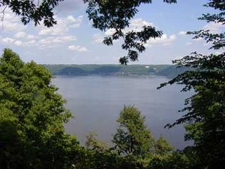
Frontenac State Park is a state park of Minnesota, United States, on the Mississippi River 10 miles (16 km) southeast of Red Wing. The park is notable both for its history and for its birdwatching opportunities. The centerpiece of the park is a 430-foot-high (130 m), 3-mile-long (4.8 km) steep limestone bluff overlooking Lake Pepin, a natural widening of the Mississippi. The bluff is variously called Garrard's Bluff or Point No-Point, the latter name coming from riverboat captains because of the optical illusion that it protruded into the Mississippi River. There is a natural limestone arch on the blufftop called In-Yan-Teopa, a Dakota name meaning "Rock With Opening". Park lands entirely surround the town of Frontenac, once a high-class resort at the end of the 19th century.

The Chickasaw Bluff is the high ground rising about 50 to 200 feet (20–60 m) above the flood plain between Fulton in Lauderdale County, Tennessee and Memphis in Shelby County, Tennessee.

The Chalk Bluffs is a barren chalk escarpment in the northeastern part of the U.S. state of Colorado, stretching from the Wyoming border east of I-25 to near the South Platte River in Logan County and Weld County.

The Battle of St. John's Bluff was fought from October 1–3, 1862, between Union and Confederate forces in Duval County, Florida, during the American Civil War. The battle resulted in a significant Union victory, helping secure their control of the Jacksonville area.

The short-faced bears is an extinct bear genus that inhabited North America during the Pleistocene epoch from about 1.8 Mya until 11,000 years ago. It was the most common early North American bear and was most abundant in California. There are two recognized species: Arctodus pristinus and Arctodus simus, with the latter considered to be one of the largest known terrestrial mammalian carnivores that has ever existed. It has been hypothesized that their extinction coincides with the Younger Dryas period of global cooling commencing around 10,900 BC.
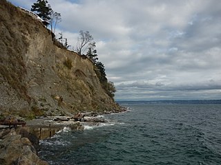
The geomorphological term feeder bluff is not a standard, widely accepted geologic term; its use has been limited to the Puget Sound region. The concept was apparently first discussed at Western Washington University. The term feeder bluff has been applied to certain coastal cliffs or headlands that provide sediment to down-current beaches as the result of wave action on the bluff.

Fort Assumption was a French fortification constructed in 1739 on the fourth Chickasaw Bluff on the Mississippi River at present day Memphis, Tennessee. The fort was used as a base against the Chickasaw in the abortive Campaign of 1739.
The Mississippi River Trail is a designated bicycle and pedestrian trail that traverses the shores of the Mississippi River in the United States. The trail goes from the headwaters at Lake Itasca in Minnesota to near the mouth of the river in Venice, Louisiana. Much of the trail follows roadways used by motor vehicles, although some of the route is on multi-use trails.
Bluff River, a mostly perennial stream of the Dumaresq–Macintyre catchment within the Murray–Darling basin, is located in the Northern Tablelands district of New South Wales, Australia.


