
Renfrewshire is one of the 32 council areas of Scotland.

Lochwinnoch is a village in the council area and historic county of Renfrewshire in the west central Lowlands of Scotland. Lying on the banks of Castle Semple Loch and the River Calder, Lochwinnoch is chiefly a residential dormitory village serving nearby urban centres such as Glasgow and Paisley. Its population in 2001 was 2628 and in 2022 was 2769.

Newton Mearns is a suburban town and the largest settlement in East Renfrewshire, Scotland. It lies 7 miles (11 km) southwest of Glasgow City Centre on the main road to Ayrshire, 410 feet (125 m) above sea level. It has a population of approximately 26,993, stretching from Whitecraigs and Kirkhill in the northeast to Maidenhill in the southeast, to Westacres and Greenlaw in the west and Capelrig/Patterton in the northwest.
Howwood is a village in Renfrewshire, Scotland. It is between Johnstone and Lochwinnoch, just off the A737 dual carriageway between the nearby town of Paisley and the Ayrshire border. It is served by Howwood railway station.
Calder River or River Calder may refer to:

The River Cart is a tributary of the River Clyde, Scotland, which it joins from the west roughly midway between the towns of Erskine and Renfrew and opposite the town of Clydebank.

Castle Semple Loch is a 1.5-mile-long (2.5 km) inland freshwater loch at Lochwinnoch in Renfrewshire, Scotland. Originally part of an estate of the same name, it is now administered by Clyde Muirshiel Regional Park as a watersports centre. An RSPB bird sanctuary is located on the loch's southern shore.

Renfrewshire or the County of Renfrew is a historic county, registration county and lieutenancy area in the west central Lowlands of Scotland. The lieutenancy area covers the three modern council areas of Inverclyde, Renfrewshire and East Renfrewshire, and this area is occasionally termed Greater Renfrewshire to distinguish it from the modern council area called Renfrewshire. The historic county additionally included territory on the south-western edge of Glasgow which was gradually transferred to the administrative area of the city as it grew.

The South Calder Water, known locally as "The Cawder", or simply "Calder", is a river in Scotland. It runs west from the high plateau between Shotts and Fauldhouse to its joining with the much larger River Clyde.
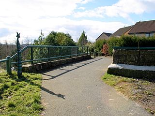
Lochwinnoch railway station was a railway station serving the village of Lochwinnoch, Renfrewshire, Scotland. The station was part of the Dalry and North Johnstone Line on the Glasgow and South Western Railway.

Castle Semple railway station was intended to be a railway station that would have served the village of Howwood, Renfrewshire, Scotland, as part of the Dalry and North Johnstone Line on the Glasgow and South Western Railway.

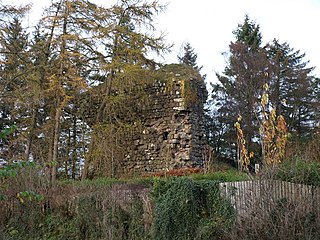
Belltrees Peel is a medieval tower situated on a peninsula in Castle Semple Loch in Renfrewshire, Scotland, on which was once an island.

Clyde Muirshiel Regional Park is the collective name for areas of countryside set aside for conservation and recreation on the South Clyde estuary in Scotland.

The Levern Water, is a small river in East Renfrewshire and Glasgow, Scotland. It rises in the Long Loch, and flows generally north and east, past the towns of Neilston and Barrhead, for a total distance of 9 miles (14 km). It empties into the White Cart River.

Castle Semple is a former mansion house located in Renfrewshire, Scotland. It is situated near the eastern end of Castle Semple Loch, within Clyde Muirshiel Regional Park.
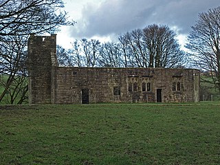
Castle Semple Collegiate Church is located in Renfrewshire, Scotland. It is situated near the eastern end of Castle Semple Loch, within Clyde Muirshiel Regional Park, and 2 miles (3.2 km) west of Howwood on the B787, then on to the B776. The late Gothic church is under the protection of Historic Environment Scotland as a Scheduled monument.
The lands of Elliston, previously Elliotston or Eliotstoun or Elliestoun in the Parish of Lochwinnoch were part of the holdings of the Barony of Elliston, later a part of the Castle Semple barony and estates. The ruins of the castle lie a short distance from Howwood in Renfrewshire in a private garden on a minor road between the A737 and the B776. The name may have derived from earlier holders of the lands, however the Sempill family held them since at least 1220. The castle was abandoned circa 1550 when John Sempill, 1st Lord Sempill moved to a new castle at Castleton which he renamed Castle Semple.
The ruins of The Peel of Castle Semple or the Castle Semple Loch Peel Tower, once designated in Scottish Reformation times as the Defender of the Faith lie in Castle Semple Loch, Parish of Lochwinnoch, Renfrewshire, Scotland. The castle stands on a rocky islet which due to drainage works and farming activities has now become linked to the shoreline through a curved earthen embankment. Semple is sometimes written as 'Sempill'; however, for consistency the more commonly found spelling will be used here.

Windy Hill is a 316 metres (1.037 feet) high hill in Renfrewshire, Scotland. It is one of the TuMPs of the Lowlands.
Castle Semple Rowing Club is a rowing club on the Castle Semple Loch, based at Lochwinnoch, Renfrewshire, Central Lowlands, Scotland. The club is affiliated to Scottish Rowing.


