Loma de Cabrera is the second largest city in the province of Dajabón, Dominican Republic. It is located in the northwest portion of the country, in the Cibao region.
Argamasilla de Calatrava is a municipality in the Province of Ciudad Real, Castile-La Mancha, Spain. It has a population of 5,408.
Santo Antônio do Sudoeste is a municipality in the state of Paraná, Brazil with a population of 18,000 inhabitants. It is on the border between Argentina and Brazil, opposite the Argentine city of San Antonio, Misiones. The San Antonio River separates the two cities.
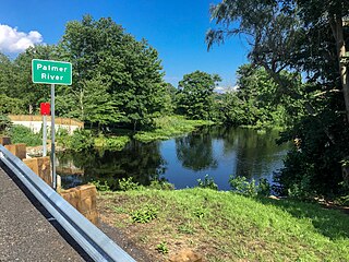
The Palmer River is a river in the U.S. states of Massachusetts and Rhode Island. It flows approximately 17 km (11 mi).

San Luis de Palenque is a town and municipality in the Department of Casanare, Colombia. The town is on a bend of the Pauto River, a tributary of the Meta River.
Port-Salut is a coastal commune in the Sud department of Haiti.

Borox is a municipality located in the province of Toledo, Castile-La Mancha, Spain. According to the 2006 census (INE), the municipality has a population of 2640 inhabitants.
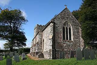
Twitchen is a village and civil parish in Devon, England, located within the North Devon local authority area. Historically it formed part of South Molton Hundred. The population was 145 in 1801; 163 in 1901 and 70 in 2001. Twitchen is recorded in the Domesday Book as being part of the manor of Alvred D'Epaignes having been held by freely by Beorhtweald in the time of King Edward, before the Norman conquest in 1066.
Fort-Liberté is an arrondissement in the Nord-Est department of Haiti. As of 2015, the population was 60,632 inhabitants. Postal codes in the Fort-Liberté Arrondissement start with the number 21.
Ouanaminthe is an arrondissement in the Nord-Est department of Haiti. As of 2015, the population was 146,484 inhabitants. Postal codes in the Ouanaminthe Arrondissement start with the number 22.
Vallières is an arrondissement in the Nord-Est department of Haiti. As of 2015, the population was 71,851 inhabitants. Postal codes in the Vallières Arrondissement start with the number 24.
Scott Inlet is a body of water in the Qikiqtaaluk Region of Nunavut, Canada. It is an arm of Baffin Bay. Scott Island lies in its middle. At its south end, it splits into Clark and Gibbs Fiords. The Inuit community of Clyde River is approximately 120 km (75 mi) to the southeast.

Porédaka is a town and sub-prefecture in the Mamou Prefecture in the Mamou Region of Guinea. It is located roughly 55 kilometres (34 mi) northeast of Mamou. The Battle of Porédaka took place here on 13 November 1896, during which French colonial troops decisively defeated the last forces of the Imamate of Futa Jallon, after which Futa Jallon was annexed into Senegambia.
The Pedernales River (Hispaniola) is a river that forms the southernmost part of the international boundary between the Dominican Republic and Haiti.
The Rivière Bouyaha is a river of Haiti.
Soutice is a municipality and village in Benešov District in the Central Bohemian Region of the Czech Republic.

Manakhah is a village in west-central Yemen. It is located in the San‘a’ Governorate, on the road between Sana'a and al-Hodeida, located in the Haraz mountains. It was once home to a Jewish community, until their emigration to Israel in the 19th and 20th century. German geographer, Carl Rathjens, visited the town in the early 1930s.
The Bon Accord River is a river of Grenada.

The Appalachia Nunataks are a group of nunataks rising to about 600 metres (2,000 ft) on the west side of the Elgar Uplands, Alexander Island, Antarctica. They are situated 5.62 km southwest of Lyubimets Nunatak, 9 km southwest of Kozhuh Peak and 9.65 km north of Atanasov Ridge, and surmount Nichols Snowfield to the west. The feature was named by the United Kingdom Antarctic Place-Names Committee in 1977 after Appalachia, the 1902 Frederick Delius composition, in association with Delius Glacier and the names of composers in this area.
Mindhola River is a river in western India in Gujarat whose origin is near Doswada, Songadh. Its basin has a maximum length of 105 km (65 mi). The total catchment area of the basin is 1,518 km2 (586 sq mi).