| Rivière de Cavaillon | |
|---|---|
 | |
| Country | Haiti |
The Rivière de Cavaillon is a river of Haiti.
| Rivière de Cavaillon | |
|---|---|
| | |
| Country | Haiti |
The Rivière de Cavaillon is a river of Haiti.
Nippes is one of the ten departments of Haiti. It is the most recent department, having been split from Grand'Anse in 2003. The capital of the department is Miragoâne.

Kladanj is a town and municipality located in Tuzla Canton of the Federation of Bosnia and Herzegovina, an entity of Bosnia and Herzegovina. Kladanj is located on road from Tuzla to Sarajevo along the river Drinjača, at the base of Konjuh mountain.

Môle-Saint-Nicolas is a commune in the north-western coast of Haiti. It is the chief town of the Môle-Saint-Nicolas Arrondissement in the department of Nord-Ouest. Christopher Columbus' first voyage to the Americas landed at the site of what is now Môle-Saint-Nicolas on December 6, 1492. The town received its present name after France gained control of the western part of Hispaniola in 1697.
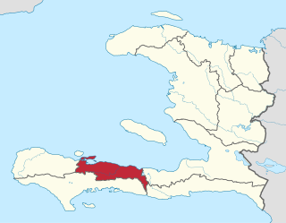
Cavaellon or Cavaillon, is a commune and a rural town located in the Aquin Arrondissement of the Sud department of Haiti.
Anse d'Hainault is an arrondissement of the Grand'Anse Department located in southwestern Haiti. As of 2015, the population was 98,522 inhabitants. Postal codes in the Anse d'Hainault Arrondissement start with the number 72.
Port-Salut is a coastal commune in the Sud department of Haiti.
Corail is an arrondissement of the Grand'Anse department, located in southwestern Haiti. As of 2015, the population was 131,561 inhabitants. Postal codes in the Anse d'Hainault Arrondissement start with the number 73.

Cascajares de Bureba is a municipality located in the province of Burgos, Castile and León, Spain. According to the 2004 census (INE), the municipality had a population of 54 inhabitants.
Plasencia de Jalón is a municipality located in the province of Zaragoza, Aragon, Spain. According to the 2004 census (INE), the municipality has a population of 368 inhabitants.
Bocigas is a municipality located in the province of Valladolid, Castile and León, Spain. According to the 2004 census (INE), the municipality has a population of 129 inhabitants.

The River Sid is a minor river in East Devon. It flows for 6.5 miles (10.5 km) southwards from a source in Crowpits Covert at a height of 206 metres above sea level. The source is at the head of a goyle or small ravine.
Miragoâne is an arrondissement in the Nippes department of Haiti. As of 2015, the population was 141,826 inhabitants. Postal codes in the Miragoâne Arrondissement start with the number 74.
Port-Salut is an arrondissement in the Sud department of Haiti. As of 2015, the population was 73,845 inhabitants. Postal codes in the Port-Salut Arrondissement start with the number 82.

The Acul River is a river of Haiti.
The Grande Rivière de Jacmel or Rivière de la Cosse, is a river in Haiti. It is approximately 45 kilometers long.
The Grande Rivière de Nippes is a river of Haiti.
The Rivière la Quinte is a river of Haiti.
The Ravine du Sud is a river of Haiti.

National Cycle Network (NCN) Route 647 is a Sustrans National Route that runs from Clumber Park to Harby 53.233°N 0.683°W. The route is 19.6 miles (31.5 km) in length and is fully open and signed in both directions.
Coordinates: 18°14′N73°41′W / 18.233°N 73.683°W

A geographic coordinate system is a coordinate system that enables every location on Earth to be specified by a set of numbers, letters or symbols. The coordinates are often chosen such that one of the numbers represents a vertical position and two or three of the numbers represent a horizontal position; alternatively, a geographic position may be expressed in a combined three-dimensional Cartesian vector. A common choice of coordinates is latitude, longitude and elevation. To specify a location on a plane requires a map projection.
| This article related to a river in Haiti is a stub. You can help Wikipedia by expanding it. |