Live Oak County is a county located in the U.S. state of Texas. As of the 2010 census, its population was 11,531. Its county seat is George West. The county was named for the groves of live oak within its borders.

Artibonite is one of the ten departments of Haiti. With an area of 4,887 km2 it is Haiti's largest department. As of 2015, its estimated population was 1,727,524. The region is the country's main rice-growing area. The main cities are Gonaïves and Saint-Marc. In February 2004 an insurgency tried unsuccessfully to declare Artibonite's independence.

Centre is one of the ten departments of Haiti, located in the center of the country along the border with the Dominican Republic. As of 2015, its estimated population was 746,236. Its capital is Hinche. It borders the Dominican Republic to the east and is the only landlocked department in Haiti.
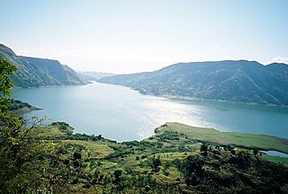
The Rivière Soliette or Arroyo Blanco is a river in the southwest of the Dominican Republic. On 24 May 2004, it overran its banks resulting in the death of over one thousand individuals, with hundreds more injured and homeless near the city of Jimani.

The Ulhas River is a west flowing river in Western India in the state of Maharashtra draining an area of 4,637 km2.

Kenscoff is a commune in the Port-au-Prince Arrondissement, in the Ouest department of Haiti, located in the foothills of the Chaîne de la Selle mountain range, some 10 kilometres to the southeast of the capital city of Port-au-Prince. The altitude is approximately 1500 meters, making the town the highest permanent settlement in the Caribbean. Because of its altitude, the temperature is on average cooler than the capital and during winter months can be chilly relative to the rest of the country. It has a population of around 52,200.
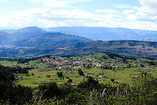
Tópaga is a town and municipality in the Sugamuxi Province, part of the Colombian department of Boyacá. Tópaga is situated on the Altiplano Cundiboyacense with the urban center at an altitude of 2,900 metres (9,500 ft) while the topography varies over the municipality from 2,400 metres (7,900 ft) to 3,200 metres (10,500 ft). It borders Nobsa and Corrales in the west, in the east Mongua and Gámeza, in the north Gámeza and in the south Monguí and Sogamoso. Department capital Tunja is 98 kilometres (61 mi) away. Chicamocha River flows through Tópaga.

Bahon, sometimes called Bohon, is a commune in Grande-Rivière-du-Nord Arrondissement in the Nord, department of Haiti. It is located on the Grand Rivière du Nord (river). It was formerly (1915) located on the railroad south from Cap-Haïtien.
Arcahaie is an arrondissement in the Ouest of Haiti. As of 2015, the population was 198,551 inhabitants. Postal codes in the Arcahaie Arrondissement start with the number 64.
Belle-Anse is an arrondissement in the Sud-Est department of Haiti. As of 2015, the population was 158,081 inhabitants. Postal codes in the Belle-Anse Arrondissement start with the number 93.
Cap-Haïtien is an arrondissement in the Nord department of Haiti and is the second important city of the country. Known as the historical and touristic capital of the country. Cap-Haïtien was founded in 1670 by the French settler Bertrand d'Ogeron de La Bouëre. As of 2015, the population was 356,908 inhabitants. The city is governed by three mayors elected by popular vote every 5 years and also represented in the National Assembly of Haiti with one member elected every 4 years. Postal codes in Cap-Haïtien Arrondissement start with the number 11.
Croix-des-Bouquets is an arrondissement in the Ouest Department of Haiti. As of 2015, the population was 474,806 inhabitants. Postal codes in the Croix-des-Bouquets Arrondissement start with the number 63.
Jacmel is an arrondissement in the Sud-Est department of Haiti. As of 2015, the population was 338,728 inhabitants.

Port-au-Prince is an arrondissement in the Ouest department of Haiti. It had 2,109,516 inhabitants at the 2003 Census which was estimated to have risen to 2,759,991 in 2015 in an area of 735.78 sq km. Postal codes in the Port-au-Prince Arrondissement start with the number 61.

The Grande Rivière de Jacmel or Rivière de la Cosse, is a river in Haiti. It is approximately 45 kilometers long.
The Momance River is a river of Haiti.
The Rivière Montrouis is a river of Haiti.
The Rivière de Bainet is a river of Haiti.
The Rivière l’Estère is a river of Haiti.