| Rivière de Saint-Marc | |
|---|---|
 | |
| Country | Haiti |
The Rivière de Saint-Marc is a river of Haiti.
| Rivière de Saint-Marc | |
|---|---|
| | |
| Country | Haiti |
The Rivière de Saint-Marc is a river of Haiti.

Artibonite is one of the ten departments of Haiti. With an area of 4,887 km2 it is Haiti's largest department. As of 2015, its estimated population was 1,727,524. The region is the country's main rice-growing area. The main cities are Gonaïves and Saint-Marc. In February 2004 an insurgency tried unsuccessfully to declare Artibonite's independence.

Centre is one of the ten departments of Haiti, located in the center of the country along the border with the Dominican Republic. As of 2015, its estimated population was 746,236. Its capital is Hinche. It borders the Dominican Republic to the east and is the only landlocked department in Haiti.

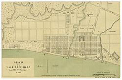
Saint-Marc is a commune in western Haiti in Artibonite. Its geographic coordinates are 19°7′N72°42′W. At the 2003 Census the commune had 160,181 inhabitants. It is one of the biggest cities, second to Gonaïve, between Port-au-Prince and Cap-Haïtien.

The Artibonite River is a 320 km long river in Haiti. It is the longest as well as the most important river in Haiti and the longest on the island of Hispaniola. Forming part of the international border between Haiti and the Dominican Republic, the river's sources are in the Cordillera Central in the Dominican Republic, however most of its length lies in Haiti. The river empties into the Gulf of Gonâve.

Dessalines is an arrondissement in the Artibonite department of Haiti. The arrondissement is named after its main city, Dessalines. The city, in turn, is named after the Haitian Revolution leader Jean-Jacques Dessalines. The arrondissement contains four communes: the city of Dessalines, Desdunes, Grande Saline, and Petite Rivière de l'Artibonite.
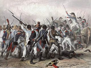
The Battle of Crête-à-Pierrot was a major battle of the Haitian Revolution taking place from 4 March until 24 March 1802.
Gros-Morne is an arrondissement in the Artibonite department of Haiti.

Bahon, sometimes called Bohon, is a commune in Grande-Rivière-du-Nord Arrondissement in the Nord, department of Haiti. It is located on the Grand Rivière du Nord (river). It was formerly (1915) located on the railroad south from Cap-Haïtien.

Milot is a commune in the Nord department of Haiti, 12 miles south of Cap-Haïtien. It is the site of Sans-Souci Palace, one of Haiti's most revered landmarks. The Citadelle Laferrière, Haiti's best-known landmark, is five miles (8 km) by road to the south. The town also hosts a hospital, Hôpital Sacré Coeur, run by the Sovereign Military Order of Malta and the Crudem Foundation, Inc. It was the capital of the State of Haiti.
Cap-Haïtien is an arrondissement in the Nord department of Haiti and is the second important city of the country. Known as the historical and touristic capital of the country. Cap-Haïtien was founded in 1670 by the French settler Bertrand d'Ogeron de La Bouëre. As of 2015, the population was 356,908 inhabitants. The city is governed by three mayors elected by popular vote every 5 years and also represented in the National Assembly of Haiti with one member elected every 4 years. Postal codes in Cap-Haïtien Arrondissement start with the number 11.
Gonaïves is an arrondissement in the Artibonite department of Haiti. It has 263,858 inhabitants. Postal codes in the Gonaïves Arrondissement start with the number 41.
Saint-Marc is an arrondissement in Artibonite department of Haiti. It has 268,499 inhabitants. Postal codes in the Saint-Marc Arrondissement start with the number 43.
Tatatila is a municipality located in the mountainous central zone of Veracruz, Mexico, about 26 km from state capital Xalapa. It has a surface area of 82.25 km2. It is located at 19°42′N97°07′W.
The Rivière la Quinte is a river of Haiti.
The Rivière Bouyaha is a river of Haiti.
The Rivière Canot is a river of Haiti.
The Rivière de Fer à Cheval is a river of Haiti. It is the primary tributary of the Artibonite River. This means that excess flow of water into the river can indirectly cause pressure on the Péligre Dam. This is notably the case in the aftermath of large-scale storms and hurricanes that hit Haiti.
The Rivière du Limbè is a river of Haiti.
Artibonite Valley is a valley predominantly in Haiti, on the island of Hispaniola. The Artibonite River flows through the valley, with headwaters in the Dominican Republic as well.
Rivière Blanche is a river in Haiti in Artibonite of the Dessalines Arrondissement.
Coordinates: 19°07′N72°42′W / 19.117°N 72.700°W

A geographic coordinate system is a coordinate system that enables every location on Earth to be specified by a set of numbers, letters or symbols. The coordinates are often chosen such that one of the numbers represents a vertical position and two or three of the numbers represent a horizontal position; alternatively, a geographic position may be expressed in a combined three-dimensional Cartesian vector. A common choice of coordinates is latitude, longitude and elevation. To specify a location on a plane requires a map projection.
| This article related to a river in Haiti is a stub. You can help Wikipedia by expanding it. |