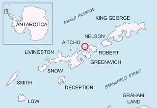
Murgash Glacier is the 3.4 km long and 3.2 km wide glacier on Greenwich Island in the South Shetland Islands, Antarctica situated southeast of Yakoruda Glacier, south of Teteven Glacier, southwest of Traub Glacier and west-northwest of Bravo Glacier. It is bounded by Lloyd Hill on the northwest, Tile Ridge on the east and Hebrizelm Hill on the southeast, and drains southwards into Kramolin Cove in McFarlane Strait between Yovkov Point and Kaspichan Point.

Musala Glacier on Greenwich Island in the South Shetland Islands, Antarctica is situated northeast of Targovishte Glacier, east-northeast of Zheravna Glacier and southeast of Fuerza Aérea Glacier. It is bounded by St. Kiprian Peak to the south, Vratsa Peak to the southwest, central Breznik Heights to the west, and Ilarion Ridge bordering Hardy Cove to the northeast, extends 2 nautical miles in east-west direction and 1.2 nautical miles in north-south direction, and drains eastwards into Bransfield Strait north of Fort Point.

Shabla Knoll rises to over 400 m (1,312 ft) in Delchev Ridge, Tangra Mountains, Livingston Island in the South Shetland Islands, Antarctica surmounting Sopot Ice Piedmont to the north and Pautalia Glacier to the southwest.

Devesil Bight is the 5.8 km wide embayment indenting for 2.2 km the southeast coast of Robert Island in the South Shetland Islands, Antarctica between Kermen Peninsula and the 2.7 km peninsula ending up in Robert Point. Entered between Edwards Point and Robert Point. Shape enhanced as a result of glacier retreat in the late 20th and early 21st century.

Santa Cruz Point, also Spencer Bluff, is a rocky point forming the east extremity of Greenwich Island in the South Shetland Islands, Antarctica and the southwest side of the entrance to English Strait. Surmounted by Bogdan Ridge on the west.

Kitchen Point is a rocky point at the east end of Tirizis Island off the east coast of Robert Island in the South Shetland Islands, Antarctica. It is projecting into Bransfield Strait to form the southeast side of the entrance to Kozloduy Cove and the north side of the entrance to Kruni Cove.

Fort William Point is the conspicuous flat-topped rocky headland forming the northwest extremity of Coppermine Peninsula and Robert Island in the South Shetland Islands, Antarctica. The point is a northwest entrance point of English Strait and forms the west side of the entrance to Carlota Cove.

Newell Point is the rocky point forming the northeast extremity of Robert Island in the South Shetland Islands, Antarctica and is a northwest entrance point of Nelson Strait.

Spark Point, also Canto Point, is a rocky point forming the northwest side of the entrance to both Discovery Bay and Galápagos Cove, and the east side of the entrance to Jambelí Cove in the northeast of Greenwich Island in the South Shetland Islands, Antarctica. The point ends up in a conspicuous monolithic formation and has an adjacent ice-free area of 164 hectares. The area was visited by early 19th century sealers.

Bajo Nunatak is a conspicuous rocky peak rising to 210 m at the south edge of the ice cap of Robert Island in the South Shetland Islands, Antarctica. The nunatak surmounts Zahari Point to the southeast, Micalvi Cove to the east-southeast, and English Strait to the southwest.

Cecilia Island is the ice-free southernmost island of the Aitcho group on the west side of English Strait in the South Shetland Islands, Antarctica. Extending 910 by 450 m, surface area 36 hectares. The area, visited by American and English sealers in the early 19th century, nowadays has become a popular tourist site frequented by Antarctic cruise ships.

Ongley Island is a rugged rocky island lying off the north coast of Greenwich Island in the South Shetland Islands, Antarctica. Extending 1.35 km (0.84 mi) in west-northwest direction and 470 m (510 yd) wide, with a surface area of 44 hectares. The area was visited by early 19th century sealers.

Romeo Island is a rocky island lying off the north coast of Greenwich Island and west of Aitcho Islands in the South Shetland Islands, Antarctica. Extending 1.35 km (0.84 mi) in west-northwest direction and 470 m (510 yd) wide, with a surface area of 44 hectares. The area was visited by early 19th century sealers.

Cornwall Island is a low ice-free island off the north coast of Robert Island in the South Shetland Islands, Antarctica. Surface area 15 hectares. Mónica Rock is lying 1.65 km (1.03 mi) west of the island and 3.4 km (2.1 mi) north of Passage Rock, 2.84 km (1.76 mi) east of Table Island and 2 km (1.2 mi) south of Potmess Rocks. The area was visited by early 19th century sealers operating from nearby Clothier Harbour.

Labbé Point is a point projecting 600 m (660 yd) into the southwest part of Discovery Bay from Parvomay Neck, Greenwich Island in the South Shetland Islands, Antarctica with an adjacent ice-free area of 11 hectares. The point forms the northwest side of the entrance to Basullo Cove and the east side of the entrance to Vinett Cove. The small Basso Island is linked by a mainly submerged spit to the north side of Labbé Point.

Frederick Rocks is a group of rocks lying in Barclay Bay on the north side of Livingston Island in the South Shetland Islands, Antarctica. The area was visited by early 19th century sealers operating on nearby Byers Peninsula.

Misnomer Point is the ice-free tipped point projecting 400 m westwards from the northwest coast of Alfatar Peninsula, Robert Island in the South Shetland Islands, Antarctica and forming the east side of the entrance to Carlota Cove. The area was visited by early 19th century sealers operating from Clothier Harbour.

Figueroa Point is an ice-free point at the northeast extremity of Greenwich Island in the South Shetland Islands, Antarctica forming the southeast side of the entrance to Galápagos Cove. Dovizio Rock is lying 190 m (210 yd) to the northeast, Ibar Rocks are centred 860 m (940 yd) to the southeast, Bonert Rock62°27′01.8″S59°42′58.3″W is 730 m (800 yd) to the south-southeast and Rosales Rocks62°26′57.5″S59°43′16.4″W are 500 m (550 yd) south by east of Figueroa Point. The area was visited by early 19th century sealers.

Priboy Rocks is the group of rocks off the east coast of Robert Island in the South Shetland Islands, Antarctica, extending 1.65 km (1.03 mi) in east-west direction and 1.2 km (0.75 mi) in north-south direction.

Glogovo Passage is the 110 metre wide passage between Zverino Island on the west-southwest and Cave Island on the east-northeast in the Meade group off Archar Peninsula, the northwest extremity of Greenwich Island in the South Shetland Islands.


