
Waynesboro is an independent city in the Commonwealth of Virginia. As of the 2020 census, the population was 22,196.

Nelson County is a county located in the Commonwealth of Virginia, in the United States. As of the 2010 census, the population was 14,775. Its county seat is Lovingston.

Surry County is a county located in the U.S. state of North Carolina. As of the 2020 Census, the population was 71,359. Its county seat is Dobson, and its largest city is Mount Airy.

The Great Appalachian Valley, also called The Great Valley or Great Valley Region, is one of the major landform features of eastern North America. It is a gigantic trough—a chain of valley lowlands—and the central feature of the Appalachian Mountain system. The trough stretches about 1,200 miles (1,900 km) from Quebec to Alabama and has been an important north–south route of travel since prehistoric times.
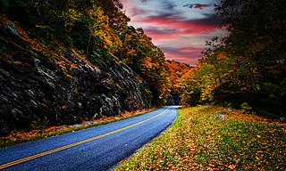
The Blue Ridge Parkway is a National Parkway and All-American Road in the United States, noted for its scenic beauty. The parkway, which is America's longest linear park, runs for 469 miles (755 km) through 29 Virginia and North Carolina counties, linking Shenandoah National Park to Great Smoky Mountains National Park. It runs mostly along the spine of the Blue Ridge, a major mountain chain that is part of the Appalachian Mountains. Its southern terminus is at U.S. Route 441 (US 441) on the boundary between Great Smoky Mountains National Park and the Qualla Boundary of the Eastern Band of Cherokee Indians in North Carolina, from which it travels north to Shenandoah National Park in Virginia. The roadway continues through Shenandoah as Skyline Drive, a similar scenic road which is managed by a different National Park Service unit. Both Skyline Drive and the Virginia portion of the Blue Ridge Parkway are part of Virginia State Route 48 (SR 48), though this designation is not signed.

The Blue Ridge Mountains are a physiographic province of the larger Appalachian Mountains range. The mountain range is located in the eastern United States, and extends 550 miles southwest from southern Pennsylvania through Maryland, West Virginia, Virginia, North Carolina, South Carolina, Tennessee, and Georgia. This province consists of northern and southern physiographic regions, which divide near the Roanoke River gap. To the west of the Blue Ridge, between it and the bulk of the Appalachians, lies the Great Appalachian Valley, bordered on the west by the Ridge and Valley province of the Appalachian range.

The Ridge-and-Valley Appalachians, also called the Ridge and Valley Province or the Valley and Ridge Appalachians, are a physiographic province of the larger Appalachian division and are also a belt within the Appalachian Mountains extending from southeastern New York through northwestern New Jersey, westward into Pennsylvania and southward into Maryland, West Virginia, Virginia, Kentucky, Tennessee, Georgia and Alabama. They form a broad arc between the Blue Ridge Mountains and the Appalachian Plateau physiographic province. They are characterized by long, even ridges, with long, continuous valleys in between.

Skyline Drive is a 105-mile (169 km) National Parkway that runs the entire length of the National Park Service's Shenandoah National Park in the Blue Ridge Mountains of Virginia, generally along the ridge of the mountains. The drive's northern terminus is at an intersection with U.S. Route 340 (US 340) near Front Royal, and the southern terminus is at an interchange with US 250 near Interstate 64 (I-64) in Rockfish Gap, where the road continues south as the Blue Ridge Parkway. The road has intermediate interchanges with US 211 in Thornton Gap and US 33 in Swift Run Gap. Skyline Drive is part of Virginia State Route 48, which also includes the Virginia portion of the Blue Ridge Parkway, but this designation is not signed.

The Virginia Central Railroad was an early railroad in the U.S. state of Virginia that operated between 1850 and 1868 from Richmond westward for 206 miles (332 km) to Covington. Chartered in 1836 as the Louisa Railroad by the Virginia General Assembly, the railroad began near the Richmond, Fredericksburg and Potomac Railroad's line and expanded westward to Orange County, reaching Gordonsville by 1840. In 1849, the Blue Ridge Railroad was chartered to construct a line over the Blue Ridge Mountains for the Louisa Railroad which reached the base of the Blue Ridge in 1852. After a decision from the U.S. Supreme Court, the Louisa Railroad was allowed to expand eastward from a point near Doswell to Richmond.
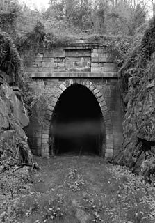
The Blue Ridge Tunnel is a historic railroad tunnel built during the construction of the Blue Ridge Railroad in the 1850s. The tunnel was the westernmost and longest of four tunnels engineered by Claudius Crozet to cross the Blue Ridge Mountains at Rockfish Gap in central Virginia.

Rockfish Gap is a wind gap located in the Blue Ridge Mountains between Charlottesville and Waynesboro, Virginia, United States, through Afton Mountain, which is frequently used to refer to the gap.
Swift Run Gap is a wind gap in the Blue Ridge Mountains located in the U.S. state of Virginia.

The Rockfish River is a 28.7-mile-long (46.2 km) tributary of the James River in central Virginia in the United States. Via the James River, it is part of the watershed of the Chesapeake Bay.

A wind gap is a gap through which a waterway once flowed that is now dry as a result of stream capture. A water gap is a similar feature, but one in which a waterway still flows. Water gaps and wind gaps often provide routes which, due to their gently inclined profile, are suitable for trails, roads, and railroads through mountainous terrain.
U.S. Route 60 (US 60) in the Commonwealth of Virginia runs 303 miles (488 km) west to east through the central part of the state, generally close to and paralleling the Interstate 64 corridor, except for the crossing of the Blue Ridge Mountains, and in the South Hampton Roads area.

State Route 151 is a primary state highway in the U.S. state of Virginia. The state highway runs 35.22 miles (56.68 km) from U.S. Route 29 at Buffalo Hill north to US 250 at Critzers Shop. SR 151 traverses the Blue Ridge foothills of western Nelson County, where the highway provides access to the Wintergreen Resort.

Afton is an unincorporated community and census-designated place in Albemarle and Nelson counties in the Commonwealth of Virginia. It is newly listed as a CDP in the 2020 census with a population of 313.
Humpback Rock is a massive greenstone outcropping near the peak of Humpback Mountain in the Blue Ridge Mountains of Augusta County and Nelson County, Virginia, United States, with a summit elevation of 3,080 feet (940 m). The rock formation is so named for the visual effect of a "hump" it creates on the western face of the mountain.