
Bell County is a county located in the southeast part of the U.S. state of Kentucky. As of the 2020 census, the population was 24,097. Its county seat is Pineville and its largest city is Middlesboro. The county was formed in 1867, during the Reconstruction era from parts of Knox and Harlan counties and augmented from Knox County in 1872. The county is named for Joshua Fry Bell, a US Representative. It was originally called "Josh Bell", but on January 31, 1873, the Kentucky legislature shortened the name to "Bell",
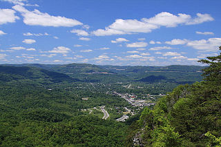
Middlesboro is a home rule-class city in Bell County, Kentucky, United States. The population was 10,334 at the 2010 U.S. census, while its micropolitan area had a population of 69,060.

Pineville is a home rule-class city in Bell County, Kentucky, United States. It is the seat of its county. The population was 1,732 as of the 2010 census. It is located on a small strip of land between the Cumberland River and Pine Mountain.

Cumberland Gap is a town in Claiborne County, Tennessee, United States. Its population was 313 at the 2020 census, and estimated to be 315 in 2023. The town is located below the Cumberland Gap, a historic mountain pass for which is the town's namesake, and inside of the boundaries of Cumberland Gap National Historical Park.

The Cumberland Plateau is the southern part of the Appalachian Plateau in the Appalachian Mountains of the United States. It includes much of eastern Kentucky and Tennessee, and portions of northern Alabama and northwest Georgia. The terms "Allegheny Plateau" and the "Cumberland Plateau" both refer to the dissected plateau lands lying west of the main Appalachian Mountains. The terms stem from historical usage rather than geological difference, so there is no strict dividing line between the two. Two major rivers share the names of the plateaus, with the Allegheny River rising in the Allegheny Plateau and the Cumberland River rising in the Cumberland Plateau in Harlan County, Kentucky.

The Cumberland Mountains are a mountain range in the southeastern section of the Appalachian Mountains. They are located in western Virginia, southwestern West Virginia, the eastern edges of Kentucky, and eastern middle Tennessee, including the Crab Orchard Mountains. Their highest peak, with an elevation of 4,223 feet (1,287 m) above mean sea level, is High Knob, which is located near Norton, Virginia.

U.S. Route 25 or U.S. Highway 25 (US 25) is a north–south United States Numbered Highway that runs for 750 miles (1,210 km) in the Southern and Midwestern U.S. Its southern terminus is in Brunswick, Georgia, from where it proceeds mostly due north, passing through the cities of Augusta, Georgia; Greenville, South Carolina; and Asheville, North Carolina, before dividing into two branches, known as US 25W and US 25E between Newport, Tennessee, and North Corbin, Kentucky. After passing through Richmond and Lexington, Kentucky, it reaches its northern terminus at Ohio state line in Covington, Kentucky. The route is an important crossing of the Appalachian Mountains, and it is covered by three of the corridors of the Appalachian Development Highway System (ADHS). When the highway was originally established in 1926, the route extended from North Augusta, South Carolina, to Port Huron, Michigan. The southern end was extended to its current terminus in 1936, while the northern end was truncated in 1974.
The Middlesboro crater is a meteorite crater in Kentucky, United States. It is named after the city of Middlesboro, Kentucky, which today occupies much of the crater.

The Cumberland Gap National Historical Park is a United States National Historical Park located at the border between Kentucky, Tennessee, and Virginia, centered on the Cumberland Gap, a natural break in the Appalachian Mountains.
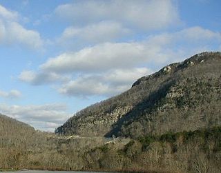
The Cumberland Gap is a pass in the eastern United States through the long ridge of the Cumberland Mountains, within the Appalachian Mountains and near the tripoint of Kentucky, Virginia, and Tennessee. At an elevation of 1,631 feet (497 m) above sea level, it is famous in American colonial history for its role as a key passageway through the lower central Appalachians.

The Cumberland Gap Tunnel is a dual-bore, four lane vehicular tunnel that carries U.S. Route 25E under Cumberland Gap National Historical Park near the intersection of Kentucky, Tennessee, and Virginia. The tunnel consists of two separate bores which carry four lanes of traffic between Cumberland Gap, Tennessee and Middlesboro, Kentucky. It is one of only two mountain vehicular tunnels in the United States that cross a state line, the other being the East River Mountain Tunnel on Interstate 77 and U.S. Route 52 between Virginia and West Virginia. The tunnel opened to traffic in 1996 and replaced a section of highway through the Cumberland Gap that had earned the nickname "Massacre Mountain" due to its hazardous design and high rate of traffic accidents.

U.S. Route 25E (US 25E) is the eastern branch of US 25 from Newport, Tennessee, where US 25 splits into US 25E and US 25W, to North Corbin, Kentucky, where the two highways rejoin. The highway, however, continues as US 25E for roughly two miles (3.2 km) until it joins Interstate 75 (I-75) in the Laurel County community of North Corbin at exit 29. The highway serves the Appalachia regions of Kentucky's Cumberland Plateau and the Ridge-and-Valley section of East Tennessee, including the urbanized areas of Corbin and Middlesboro in Kentucky and Morristown in Tennessee.
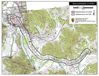
The Battle of Barbourville was one of the early engagements of the American Civil War. It took place on September 19, 1861, in Knox County, Kentucky during the campaign known as the Kentucky Confederate Offensive. The battle is considered the first Confederate victory in the commonwealth, and threw a scare into Federal commanders, who rushed troops to central Kentucky to try to repel the invasion, which was finally stopped at the Battle of Camp Wildcat in October.
The Cumberland Valley Subdivision is a railroad line owned and operated by the CSX Railroad in the U.S. states of Kentucky and Virginia. The line runs from Corbin, Kentucky, east to Big Stone Gap, Virginia, along a former Louisville and Nashville Railroad line.

Pine Mountain is a ridge in the Appalachian Mountains running through Kentucky, Virginia and Tennessee. It extends about 125 miles from near Pioneer, Tennessee, to a location near Elkhorn City, Kentucky. Birch Knob, the highest point, is 3,273 feet (998 m) above sea level and is located on the Kentucky-Virginia border. It has long been a barrier to transportation, as the Cumberland River at Pineville, Kentucky is one of only two waterways that pass through the entire ridge. The other is the Clear Fork near Jellico, Tennessee.
WMIK-FM is a radio station in Middlesboro, Kentucky along with its flagship station, WMIK-AM. At 92.7 FM and AM 560 it broadcasts 24 hours a day.
WMIK in Middlesboro, Kentucky, operates on an assigned frequency of 560 kHz with a daytime power of 2500 watts. Pre-sunrise and nighttime power are 500 watts and 88 watts respectively. The landmark radio studio is on the 19th Street Extension and Highway 441. The transmitting tower is situated one mile to the Northeast.
"Cumberland Gap" is an Appalachian folk song that likely dates to the latter half of the 19th century and was first recorded in 1924. The song is typically played on banjo or fiddle, and well-known versions of the song include instrumental versions as well as versions with lyrics. A version of the song appeared in the 1934 book, American Ballads and Folk Songs, by folk song collector John Lomax. Woody Guthrie recorded a version of the song at his Folkways sessions in the mid-1940s, and the song saw a resurgence in popularity with the rise of bluegrass and the American folk music revival in the 1950s. In 1957, the British musician Lonnie Donegan had a No. 1 UK hit with a skiffle version of "Cumberland Gap".
Alexander Alan Arthur was a Scottish-born engineer and entrepreneur active primarily in the southeastern United States in the latter half of the 19th century. Flamboyant, charismatic, and energetic, Arthur used his prominent American and European financial connections to fund numerous business ventures, most of which were overly ambitious and ultimately failed. A proponent of economic advancement in what became known as the New South, Arthur played a primary role in the development of the Cumberland Gap area, and in the course of his endeavors established the cities of Middlesboro, Kentucky and Harrogate, Tennessee. The community of Arthur, Tennessee, is named for him.
The Clover Fork is a 30-mile (48 km) tributary of the Cumberland River, draining a section of the Appalachian Mountains in Harlan County, southeast Kentucky in the United States. The river's confluence with the Martin's Fork at Harlan marks the official beginning of the Cumberland River.