
The Rosalie River is a river in Dominica. It rises on the eastern slopes of Morne Trois Pitons, flowing east to reach the Atlantic Ocean on the country's east coast, close to the town of Rosalie.
The Rosalie River is a river in Dominica. It rises on the eastern slopes of Morne Trois Pitons, flowing east to reach the Atlantic Ocean on the country's east coast, close to the town of Rosalie.

The Gulf of St. Lawrence is the outlet of the North American Great Lakes via the St. Lawrence River into the Atlantic Ocean. The gulf is a semi-enclosed sea, covering an area of about 226,000 square kilometres (87,000 sq mi) and containing about 34,500 cubic kilometres (8,300 cu mi) of water, at an average depth of 152 metres (500 ft).

The Arctic Archipelago, also known as the Canadian Arctic Archipelago, is an archipelago lying to the north of the Canadian continental mainland, excluding Greenland and Iceland.

The Northern Range is the range of tall hills across north Trinidad, the major island in the Republic of Trinidad and Tobago. The hills range from the Chaguaramas peninsula on the west coast to Toco in the east. The Northern Range covers approximately twenty-five percent of the land area of Trinidad.

Koettlitz Glacier is a large Antarctic glacier lying west of Mount Morning and Mount Discovery in the Royal Society Range, flowing from the vicinity of Mount Cocks northeastward between Brown Peninsula and the mainland into the ice shelf of McMurdo Sound.

The Kasegaluk Lagoon (Iñupiaq: Qasigialik) is a coastal lagoon located in the western part of the North Slope of Alaska. It is separated from the Chukchi Sea by a series of long, thin barrier islands that stretch south and north-east from the town of Point Lay and westwards down to Icy Cape. There are seven passes through these islands. The lagoon receives the waters from the Kukpowruk, Kokolik, and Utukok Rivers.
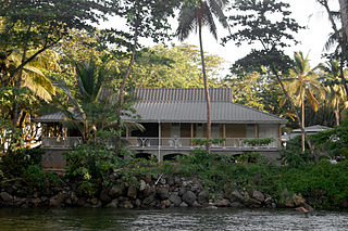
Rosalie is a village in Dominica. It is located in Saint David Parish at the northern end of Rosalie Bay, on the central east coast of the island, close to the mouth of the Rosalie River.
Pont Cassé is situated in the Saint Paul Parish in Dominica. It is located almost in the middle of Dominica, close to Belles Village northeast of the national capital, Roseau, and close to Morne Trois Pitons, the mountain which dominates the southern center of the country. As of 2006 it has a population of 100.

Tacarigua is a town in the East–West Corridor of Trinidad and Tobago, located east of Tunapuna, north of Trincity and west of Arouca. It is on the banks of the Tacarigua River. The city is governed by the Tunapuna–Piarco Regional Corporation.

Torreorgaz is a municipality in the province of Cáceres, Extremadura, Spain. According to the 2017 census (INE), the municipality has a population of 1669 inhabitants.
The Nerepis River is a river approximately 25 miles (40 km) long in New Brunswick, Canada. A popular river for canoeists and anglers, it is a tributary of the Saint John River. The river has been subjected to significant environmental stress over many years.
New Bedford Inlet is a large pouch-shaped, ice-filled embayment between Cape Kidson and Cape Brooks, along the east coast of Palmer Land. Discovered and photographed from the air in December 1940 by members of the United States Antarctic Service (USAS), and named after New Bedford, Massachusetts, the centre of the New England whaling industry in the middle of the 19th century.
Texcatepec is a municipality in the Mexican state of Veracruz, about 190 km from the state capital Xalapa. It has a surface of 153.61 km2. It is located at 20°35′N98°22′W. In 1930 the municipal head-board was established in the village of Amexac; but for the decree number 4 in 1931 returned the character of municipal head-board, to the village of Texcatepec.
The River Claire is a river on the Caribbean island of Dominica.
Clarke's River is a river on the Caribbean island of Dominica.
The Hampstead River is a river on the Caribbean island of Dominica.
The Penton River is a river on the Caribbean island of Dominica.
Petit Soufrière is a small village on the east coast of Dominica, upland from Petite Soufrière Bay in Saint David Parish. Located on the steep, rugged slopes of Morne Aux Delices at the end of the main road south from Castle Bruce, it is one of the most isolated villages in Dominica. The village immediately to its north is Saint Sauveur; to its south, though connected only by a hiking trail, is Rosalie.

The borders of the oceans are the limits of Earth's oceanic waters. The definition and number of oceans can vary depending on the adopted criteria. The principal divisions of the five oceans are the Pacific Ocean, Atlantic Ocean, Indian Ocean, Southern (Antarctic) Ocean, and Arctic Ocean. Smaller regions of the oceans are called seas, gulfs, bays, straits, and other terms. Geologically, an ocean is an area of oceanic crust covered by water.
15°22′N61°15′W / 15.367°N 61.250°W