Roscoe Nicholson

Last updated

Roscoe Conklin Nicholson (January 22, 1887 October 22, 1959) [1] was a surveyor and early advocate of conservation, who played an important role in preserving forest land in the U.S. state of Georgia in the early 20th century.

Surveying The technique, profession, and science of determining the positions of points and the distances and angles between them

Surveying or land surveying is the technique, profession, and science of determining the terrestrial or three-dimensional positions of points and the distances and angles between them. A land surveying professional is called a land surveyor. These points are usually on the surface of the Earth, and they are often used to establish maps and boundaries for ownership, locations, such as building corners or the surface location of subsurface features, or other purposes required by government or civil law, such as property sales.

United States federal republic in North America

The United States of America (USA), commonly known as the United States or America, is a country composed of 50 states, a federal district, five major self-governing territories, and various possessions. At 3.8 million square miles, the United States is the world's third or fourth largest country by total area and is slightly smaller than the entire continent of Europe's 3.9 million square miles. With a population of over 327 million people, the U.S. is the third most populous country. The capital is Washington, D.C., and the largest city by population is New York City. Forty-eight states and the capital's federal district are contiguous in North America between Canada and Mexico. The State of Alaska is in the northwest corner of North America, bordered by Canada to the east and across the Bering Strait from Russia to the west. The State of Hawaii is an archipelago in the mid-Pacific Ocean. The U.S. territories are scattered about the Pacific Ocean and the Caribbean Sea, stretching across nine official time zones. The extremely diverse geography, climate, and wildlife of the United States make it one of the world's 18 megadiverse countries.

Georgia (U.S. state) State of the United States of America

Georgia is a state in the Southeastern United States. It began as a British colony in 1733, the last and southernmost of the original Thirteen Colonies to be established. Named after King George II of Great Britain, the Province of Georgia covered the area from South Carolina south to Spanish Florida and west to French Louisiana at the Mississippi River. Georgia was the fourth state to ratify the United States Constitution, on January 2, 1788. In 1802–1804, western Georgia was split to the Mississippi Territory, which later split to form Alabama with part of former West Florida in 1819. Georgia declared its secession from the Union on January 19, 1861, and was one of the original seven Confederate states. It was the last state to be restored to the Union, on July 15, 1870. Georgia is the 24th largest and the 8th most populous of the 50 United States. From 2007 to 2008, 14 of Georgia's counties ranked among the nation's 100 fastest-growing, second only to Texas. Georgia is known as the Peach State and the Empire State of the South. Atlanta, the state's capital and most populous city, has been named a global city. Atlanta's metropolitan area contains about 55% of the population of the entire state.

Born and raised in Pine Mountain, an unincorporated community at the eastern edge of Rabun County, Georgia he was the first forest ranger in Georgia. [2] Before becoming Georgia's first forest ranger in 1912, he worked as a surveyor for the federal government.

Pine Mountain is an unincorporated community located in eastern Rabun County, Georgia, United States, at an elevation of 1661 feet. It is one of only two Georgia communities located north of South Carolina, due to a quirk of geography: the Chattooga River is the primary tributary of the Savannah River and Tugalo River specified in the 1787 Treaty of Beaufort, but runs perpendicular to them.

Rabun County, Georgia county in Georgia, United States

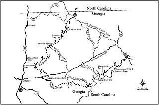
Rabun County is the northeasternmost county in the U.S. state of Georgia. As of the 2010 census, the population was 16,276. The county seat is Clayton.

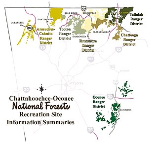
Nicholson advised the United States Forest Service in its initial and subsequent land purchases in what is now the Chattooga River Ranger District of the Chattahoochee National Forest. He and Arthur Woody are considered to be the two most important early figures in the history of the Chattahoochee National Forest. In addition to being instrumental in the early land purchases, Ranger "Nick", as he was called, worked to prevent forest fires by purchasing bloodhounds to track arsonists and building the first fire tower in the area on Rabun Bald (second-highest peak in Georgia). He also played an important role in establishing telecommunications in the region, being responsible for having telephone lines run from Clayton, Georgia to Pine Mountain.

United States Forest Service federal forest and grassland administrators

The United States Forest Service (USFS) is an agency of the U.S. Department of Agriculture that administers the nation's 154 national forests and 20 national grasslands, which encompass 193 million acres (780,000 km2). Major divisions of the agency include the National Forest System, State and Private Forestry, Business Operations, and the Research and Development branch. Managing approximately 25% of federal lands, it is the only major national land agency that is outside the U.S. Department of the Interior.

Arthur Woody was born in Suches, Georgia. He was an American conservationist and humanitarian who saw his father kill the last deer in the North Georgia mountains in 1895, and is credited with bringing deer back to the North Georgia mountains. As a forest ranger for the United States Forest Service, he served in Georgia from 1912 to 1945 and was involved in the acquisition of land in what became the Chattahoochee National Forest. He also is known for putting rainbow and brown trout in streams, restoring native brook trout, restoring turkey and black bear populations and was the driving force behind Blue Ridge Wildlife Management Area, the first of its kind in Georgia and the nation. He built lakes, fire towers, brought roads to the area, built Woody Gap School in Suches, Georgia (1940), was instrumental in building the Appalachian Trail through Georgia, and did much to help his mountain people during the Great Depression.

Rabun Bald mountain in United States of America

Rabun Bald, with an elevation of 4,696 feet (1,431 m), is the second-highest peak in the U.S. state of Georgia; only Brasstown Bald 4,784 feet (1,458 m) is higher. It is immediately southeast of Sky Valley, Georgia, and is the tallest mountain in the county. An observation tower on the summit provides hikers with views that, on clear days, extend for more than 100 miles (160 km). The hike to the top of Rabun Bald is 5.8 miles (9.3 km) round trip via the Rabun Bald Trail. The Rabun Bald Trail connects with the Bartram Trail system, which passes over the top as it winds through northeast Georgia for 37 miles (60 km).

Ranger "Nick" retired in 1952. In 1960, the Coleman River Scenic Area near Clayton, Georgia was dedicated to Ranger "Nick" following his 40 years of public service in honor of his promotion of conservation ideals and other work. [3]

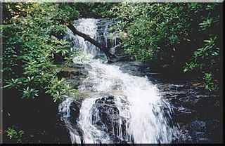
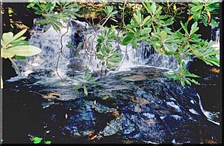
The Coleman River Scenic Area is located in Rabun County, Georgia in the Chattooga River District of the Chattahoochee National Forest. It is located at the point of confluence of Coleman River with the Tallulah River. The scenic area consists of 330 acres (1.3 km2) encompassing lower Coleman River and was dedicated in 1960 to "Ranger Nick" Nicholson following his 40 years of public service. At the point of confluence of the two rivers, the elevation is approximately 2,200 feet (670 m).

Clayton, Georgia City in Georgia, United States

Clayton is a city in Rabun County, Georgia, United States. The population was 2,047 at the 2010 census. The city is the county seat of Rabun County and is located in the Blue Ridge Mountains.

Related Research Articles

Tallulah River river in mountains of Georgia and North Carolina

The Tallulah River is a 47.7-mile-long (76.8 km) river in Georgia and North Carolina. It begins in Clay County, North Carolina, near Standing Indian Mountain in the Southern Nantahala Wilderness and flows south into Georgia, crossing the state line into Towns County. The river then travels through Rabun County and ends in Habersham County. It cuts through the Tallulah Dome rock formation to form the Tallulah Gorge and its several waterfalls. The Tallulah River intersects with the Chattooga River to form the Tugaloo River at Lake Tugalo in Habersham County, which then joins South Carolina's Seneca River at Lake Hartwell to create the Savannah River which flows southeastward into the Atlantic Ocean.

Chattooga River river in the United States of America

The Chattooga River is the main tributary of the Tugaloo River. Its headwaters are located southwest of Cashiers, North Carolina, and it stretches 57 miles (92 km) to where it has its confluence with the Tallulah River within Lake Tugalo, held back by the Tugalo Dam. The Chattooga and the Tallulah combine to make the Tugaloo River starting at the outlet of Lake Tugalo. The Chattooga begins in southern Jackson County, North Carolina, then flows southwestward between northwestern Oconee County, South Carolina, and eastern Rabun County, Georgia. The "Chattooga" spelling was approved by the US Board on Geographic Names in 1897.

Mark Twain National Forest

Mark Twain National Forest (MTNF) is a U.S. National Forest located in the southern half of Missouri. MTNF was established on September 11, 1939. It is named for author Mark Twain, a Missouri native. The MTNF covers 3,068,800 acres (12,419 km2) of which 1,506,100 acres (6,095 km2) is public owned, 78,000 acres (320 km2) of which are Wilderness, and National Scenic River area. MTNF spans 29 counties and represents 11% of all forested land in Missouri. MTNF is divided into six distinct ranger districts: Ava-Cassville-Willow Springs, Eleven Point, Houston-Rolla, Cedar Creek, Poplar Bluff, Potosi-Fredericktown, and the Salem. The six ranger districts actually comprise nine overall unique tracts of forests. Its headquarters are in Rolla, Missouri.

Chattahoochee-Oconee National Forest

The Chattahoochee-Oconee National Forest in northern Georgia comprises two United States National Forests, the Oconee National Forest in eastern Georgia and the Chattahoochee National Forest located in the North Georgia Mountains. The Chattahoochee National Forest is composed of an eastern and western forest. The western forest contains Johns Mountain, Little Sand Mountain, and Taylor Ridge. The combined total area of the Chattahoochee-Oconee National Forest is 866,468 acres (3,506 km2), of which the Chattahoochee National Forest comprises 750,145 acres (3,036 km2) and the Oconee National Forest comprises 116,232 acres (470 km2). The county with the largest portion of the eastern forest is Rabun County, Georgia, which has 148,684 acres (601.7 km2) within its boundaries.

Bartram Trail

The Bartram Trail follows the approximate route of 18th-century naturalist William Bartram’s southern journey from March 1773 to January 1777. Bartram explored much of the territory which is now the states of North and South Carolina, Georgia, Florida, Alabama, Mississippi, Louisiana and Tennessee.

Tallulah Ranger District

The Tallulah Ranger District is one of the five ranger districts of the Chattahoochee National Forest. The largest portion of the district is located in Rabun County, Georgia, which contains nearly 149,000 acres (600 km2). A portion of the Tallulah Ranger District is also found in Towns County. Both the Appalachian Trail and the Bartram Trail are located in the district.

Southern Nantahala Wilderness

The Southern Nantahala Wilderness was designated in 1984 and currently consists of 23,473 acres (94.99 km2). Approximately 11,770 acres (47.6 km2) are located in Georgia in the Chattahoochee National Forest and approximately 11,703 acres (47.36 km2) are located in North Carolina in the Nantahala National Forest. The Wilderness is managed by the United States Forest Service and is part of the National Wilderness Preservation System. The highest elevation in the Southern Nantahala Wilderness is the 5,499-foot peak of Standing Indian Mountain in North Carolina and the lowest elevation is approximately 2,400 feet (730 m). The Appalachian Trail passes through the Wilderness in both states.

Ellicott Rock Wilderness

The Ellicott Rock Wilderness was designated in 1975 and currently consists of 8,274 acres (33.48 km2) surrounding the point at which Georgia, North Carolina, and South Carolina come together. It is the only wilderness that straddles three states. Approximately 2,021 acres (8.18 km2) are located in Georgia in the Chattahoochee National Forest, approximately 3,394 acres (13.74 km2) are located in North Carolina in the Nantahala National Forest, and approximately 2,859 acres (11.57 km2) are located in South Carolina in the Andrew Pickens Ranger District of the Sumter National Forest. Bisecting the Wilderness is the Chattooga River, a Wild and Scenic River. The Wilderness is managed by the United States Forest Service and is part of the National Wilderness Preservation System.

Chattooga Ranger District

The Chattooga Ranger District is one of the five ranger districts of the Chattahoochee National Forest. The district is spread through portions of Banks, Habersham, Lumpkin, Stephens, Towns, Union and White Counties in Georgia. Some of the features within the borders of the district are the Soque River, Tray Mountain and the Tray Mountain Wilderness.

Becky Branch Falls waterfall

Becky Branch Falls is a twenty foot waterfall located in Rabun County, Georgia. The waterfall is located on the Bartram Trail in a valley called Warwoman Dell, east of Clayton, Georgia. In addition to accessing the falls via the Bartram Trail at the point where the trail crosses Warwoman Road, there is a short 0.6 mile loop trail called Becky Branch Falls Trail. This alternative trail connects is also accessed at the point where the Bartram Trail crosses Warwoman Road. The Bartram Trail also continues to nearby Martin Creek Falls. Becky Branch Falls is located within the boundaries of the Chattooga River Ranger District of the Chattahoochee National Forest.

Martin Creek Falls

Martin Creek Falls is a series of waterfalls located in Rabun County, Georgia, with the largest drop being about 30 feet. They are located on the Bartram Trail which is a National Scenic Trail in Georgia. The falls are east of Clayton, Georgia and can be accessed by taking the Bartram Trail where it crosses Warwoman Road. The trail passes Becky Branch Falls at 200 yards and then continues on for a difficult 1.8 miles to Martin Creek Falls. Martin Creek Falls are in the Chattooga River Ranger District of the Chattahoochee National Forest.

Waterfalls of North Georgia Wikimedia list article

The waterfalls of northern Georgia, U.S., are a prominent feature of the geography of that region, as well as a major focus of tourism and outdoor recreation. Many are located in state parks, national forests, wildlife management areas, and other public lands. Many are accessible—with varying degrees of ease or difficulty—via established hiking trails, and some developed areas include boardwalks, observation platforms, picnic areas, and other amenities. The Cherokee called this region "Land of a Thousand Waterfalls". The third-, fourth-, and fifth-highest waterfalls in the eastern United States are located in northern Georgia.

Southern Highroads Trail highway in South Carolina

The Southern Highroads Trail is a 364-mile loop of scenic and historic highways in the Southeastern United States. The driving trail traverses 14 counties, four states, and four national forests, providing sightseers and passersby an array of culinary, hotel, shopping and recreational options along the way.

Glassy Mountain (Georgia)

Glassy Mountain is a mountain in the Chattahoochee National Forest in Rabun County, Georgia, with its USGS GNIS summit at 34°50′44″N83°30′02″W, which is 3,415 feet (1,041 m) AMSL. It is bypassed on its northern flank by a major two-lane highway that carries U.S. Route 76 and Georgia State Route 2 east and west.

References