
East Sussex is a ceremonial county in South East England. Established in 1974 from the eastern half of Sussex, it is bordered by Kent to the north-east, West Sussex to the west, Surrey to the north-west, and the English Channel to the south. The largest settlement is the city of Brighton and Hove.

South Yorkshire is a ceremonial county in the Yorkshire and the Humber region of England. It borders North Yorkshire and West Yorkshire to the north, the East Riding of Yorkshire to the north-east, Lincolnshire and Nottinghamshire to the south-east, and Derbyshire to the south and west. The largest settlement is the city of Sheffield.

Rother is a local government district in East Sussex, England. Its council is based in Bexhill-on-Sea. The district is named after the River Rother which flows within its boundaries.

The River Rother flows from Empshott in Hampshire, England, to Stopham in West Sussex, where it joins the River Arun. At 52 kilometres (32 mi) long, most of the river lies within West Sussex except for the first 10 kilometres (6.2 mi) which lie in Hampshire. The upper river, from its source to Midhurst, has been used to power watermills, with the earliest recorded use being in 1086, when the Domesday survey was conducted. Although none are still operational, many of the buildings which housed the mills still exist, and in some cases, still retain their milling machinery. This upper section is also noted for a number of early bridges, which have survived since their construction in the fifteenth, sixteenth and seventeenth centuries.

Chichester is a local government district in West Sussex, England. Its council is based in the city of Chichester and the district also covers a large rural area to the north.

Battle is a small town and civil parish in the district of Rother in East Sussex, England. It lies 50 miles (80 km) south-east of London, 30 miles (50 km) east of Brighton and 20 miles (30 km) east of Lewes. Hastings is to the south-east and Bexhill-on-Sea to the south. Battle is in the designated High Weald Area of Outstanding Natural Beauty, and is a tourist destination and commuter town for white collar workers in the City of London. The parish population was 6,048 according to the 2001 census, increasing to 6,673 with the 2011 Census.

Burwash, archaically known as Burghersh, is a rural village and civil parish in the Rother district of East Sussex, England. Situated in the High Weald of Sussex some 15 miles (24 km) inland from the port of Hastings, it is located five miles (8 km) south-west of Hurst Green, on the A265 road, and on the River Dudwell, a tributary of the River Rother. In an area steeped in history, some nine miles (14 km) to the south-east lies Battle Abbey and eight miles (13 km) to the east is Bodiam Castle.
The Rother Valley is the valley of the River Rother, of which there are at least three in England. Rother Valley may refer to:

Ticehurst is both a village and a large civil parish in the Rother district of East Sussex, England. The parish lies in the upper reaches of both the Bewl stream before it enters Bewl Water and in the upper reaches of the River Rother flowing to the south-east. The parish includes the parish wards of Ticehurst, Flimwell and Stonegate. The linear settlements of Berner's Hill and Union Street lie between Ticehurst and Flimwell. It lies to the south-east of Tunbridge Wells, and is about ten miles (16 km) distant.

Peasmarsh is a village and civil parish in the Rother district, in the county of East Sussex in England. It is located on the A268 road between Rye and Beckley, some 3 miles (4.8 km) north-west of Rye.

Rother District Council is the local authority for Rother District in East Sussex, England. The council is elected every four years. Since the last boundary changes in 2019 the council has comprised 38 councillors representing 21 wards, with each ward electing one or two councillors.
Ashburnham is a civil parish in the Rother district of East Sussex, England, situated to the west of Battle. It includes the settlements of Brownbread Street and Ponts Green; Ashburnham Forge is also within the parish. Ashburnham shares a parish council with the neighbouring small parish of Penhurst.

Beckley is a village and civil parish in the Rother district of East Sussex, England. It is located on the B2088 minor road above the Rother Levels five miles (8 km) northwest of Rye and ten miles (16 km) from Hastings. The northern border follows the river Rother.

Mountfield is a village and civil parish in the Rother district of East Sussex, England, and three miles (5 km) north-west of Battle. It is mentioned in the Domesday Book.

Brightling is a village and civil parish in the Rother district of East Sussex, England. It is located on the Weald eight miles (13 km) north-west of Battle and four miles (6 km) west of Robertsbridge.
Dallington is a village and civil parish in the Rother district of East Sussex, England. It is located eight miles (13 km) west of Battle and five miles (8 km) east of Heathfield.
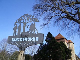
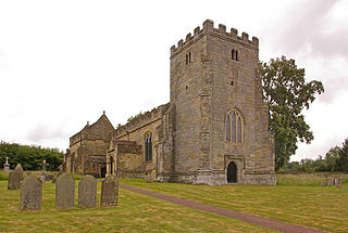
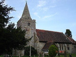
Penhurst is a village and civil parish, sharing a parish council with neighbouring Ashburnham, in the Rother district of East Sussex, England. It is located on the Weald, 4 miles (7km) west of Battle. The parish touches Ashburnham, Battle, Brightling and Catsfield. Penhurst shares a parish council with Ashburnham.

The Rother Valley Railway (RVR) is a heritage railway project based at Robertsbridge in East Sussex, England. It takes its name from the original name for what later became the Kent and East Sussex Railway, running from Robertsbridge through to Headcorn in Kent, via Tenterden. The project is to replace the "missing link" between Robertsbridge, a station on the Tonbridge to Hastings mainline, and Bodiam on the Kent and East Sussex Railway, a heritage railway which operates from Bodiam to Tenterden. A charity, supported by a society of volunteers, is attempting to re-establish the railway link. The RVR began by reinstating the first few hundred yards of line eastwards from Robertsbridge, and also a short stretch westwards from Bodiam. In 2010, the latter section was further extended to reach Junction Road. In summer 2011 work began at Robertsbridge to extend further eastwards to Northbridge Street, which entailed the rebuilding of five bridges. By June 2012, this further extension was also completed. In September 2013, a gala weekend at Robertsbridge marked the progress to date and the start of the next phase: the reinstatement of the section between Northbridge Street and Junction Road, for which statutory permissions are being sought. The RVR does not yet run regular passenger trains, but the base at Robertsbridge houses a small shop and visitor centre open to the public each Sunday, in a building formerly used as the London terminus of the Orient Express. There is also a small collection of historic railway vehicles in various states of preservation.
The western Weald is an area of undulating countryside in Hampshire and West Sussex containing a mixture of woodland and heathland areas.
