
The Maryland Transit Administration (MTA) is a state-operated mass transit administration in Maryland, and is part of the Maryland Department of Transportation. It is better known as MTA Maryland to avoid confusion with other cities' transit agencies who share the initials MTA. The MTA operates a comprehensive transit system throughout the Baltimore-Washington Metropolitan Area. There are 80 bus lines serving Baltimore's public transportation needs, along with other services that include the Light Rail, Metro Subway, and MARC Train. With nearly half the population of Baltimore residents lacking access to a car, the MTA is an important part of the regional transit picture. The system has many connections to other transit agencies of Central Maryland, Washington, D.C., Northern Virginia, and south-central Pennsylvania : WMATA, Charm City Circulator, Regional Transportation Agency of Central Maryland, Annapolis Transit, Rabbit Transit, Ride-On, and TransIT.

CUE Bus (City-University-Energysaver) is a bus service operated by the City of Fairfax, Virginia, and is completely separate from the Fairfax Connector bus service run by Fairfax County.

U.S. Route 13 is a U.S. Highway running from Fayetteville, North Carolina north to Morrisville, Pennsylvania. In the U.S. state of Maryland, the route runs 42.48 mi (68.36 km) from the Virginia border south of Pocomoke City in Worcester County north to the Delaware border in Delmar, Wicomico County, where the route intersects Route 54, which runs along the state line. The majority of the route within Maryland is a four-lane divided highway that passes through rural areas of woodland and farmland. The route also runs through a few municipalities including Pocomoke City and Princess Anne and it bypasses Salisbury and Fruitland to the east on the Salisbury Bypass, which is a freeway. US 13 intersects many major roads including the southern terminus of US 113 in Pocomoke City, Maryland Route 413 in Westover, and MD 12 and US 50 where the route is on the Salisbury Bypass. The route shares a concurrency with US 50 along a portion of the Salisbury Bypass.
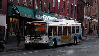
Route 15 is a bus route operated by the Maryland Transit Administration in Baltimore and its suburbs. The line currently runs from Security Square Mall, Westview Mall, Windsor Hills, or Walbrook Junction through downtown Baltimore and northeast to Overlea, with selected peak hour express trips to Perry Hall. The main roads on which it operates include Security Boulevard, Windsor Mill Road, Forest Park Avenue, Poplar Grove Street, Edmondson Avenue, Saratoga Street, Gay Street, and Belair Road, and is one of the most heavily used bus routes operated by the MTA.
Route 20 is a bus route operated by the Maryland Transit Administration in Baltimore and its suburbs. The line currently runs from Security Square Mall east through downtown Baltimore to Baltimore City Hall. The main roads on which the line operates are Old Frederick Road, Baltimore Street, Fayette Street, and Boston Street. The line serves the communities of Westview, Edmondson Village.

Route 64 is a bus route operated by the Maryland Transit Administration in Baltimore and its suburbs. The line currently runs from the intersection of North Avenue and St. Paul Street to Curtis Bay, with selected trips to Energy Parkway and Riviera Beach. The line also serves Federal Hill, Port Covington, and Brooklyn.

The Maryland Transit Administration provides the primary public bus service for the Baltimore Metropolitan Area and commuter bus service in other parts of the state of Maryland. There are currently 76 bus routes, which include 43 LocalLink routes, 12 High Frequency CityLink Routes routes, 9 express bus routes, 19 commuter bus routes, and 5 Intercounty Connector or "ICC" routes. The local and commuter bus routes operate in conjunction with one subway line, three light rail lines, MARC train service, and various connections to other transit agencies.

Route 77 is a bus route operated by the Maryland Transit Administration in the suburbs of Baltimore. The line currently runs from the Old Court Metro Subway Station in Pikesville, Maryland to the Patapsco Light Rail Stop, and serves Randallstown, Windsor Mill, Woodlawn, Catonsville, Arbutus, Halethorpe, and Lansdowne, and the campuses of UMBC and CCBC Catonsville.
LocalLink 28 is a bus route operated by the Maryland Transit Administration in Baltimore. The line currently runs from the Rogers Avenue Metro Subway Station in Northwest Baltimore to a loop in Moravia in Northeast Baltimore. Service is provided about once every 10–15 minutes during rush hour, every 20 minutes midday, every 30 minutes on Saturdays, and hourly on Sundays. The line operates primarily along the cross-town corridor of Coldspring Lane and Moravia Road, transversing Arlington, Park Heights, Roland Park, Homeland, and Montebello. The line passes several universities, including Loyola College, Notre Dame, and Morgan State University.
LocalLink 59 is a bus route operated by the Maryland Transit Administration in Baltimore and its suburbs. The line operates hourly between the Moravia loop in Northeast Baltimore and Whispering Woods, just east of Bowleys Quarters.

Greenspring is a neighborhood in the North District of Baltimore, located between the neighborhoods of Woodberry (east) and Central Park Heights (west). Its boundaries are marked by West Cold Spring Lane (north), Greenspring Avenue (east), and Springhill Avenue (south). The western edge of the neighborhood runs along Pimlico Road from West Cold Spring Lane to Park Heights Avenue, then along Park Heights Avenue to Springhill Avenue.
Saint Agnes is a neighborhood in the Southwest District of Baltimore, located between the neighborhoods of Irvington (north) and Violetville (south). Its boundaries are marked by Wilkens Avenue (south), Caton Avenue (east) and Loudon Park Cemetery (northwest). Saint Agnes Hospital is located on the opposite side (south) of Wilkens Avenue.

Beverly Hills is a neighborhood in the Northeast District of Baltimore, located between the neighborhoods of Moravia-Walther, Arcadia and Lauraville. Its boundaries are drawn by Harford Road (west), Weaver Avenue (south), Harcourt Road (east), Moravia Road (northeast) and Grindon Avenue (north).
Westgate is a neighborhood in the Southwest District of Baltimore, located between Baltimore County (west) and the city neighborhood of Ten Hills (east). Its boundaries are marked by Baltimore National Pike (north), Frederick Avenue (south), Rock Glen Avenue and Edmondson Avenue (east) and the city line (west).
West Hills is a neighborhood in the Southwest District of Baltimore, located between the neighborhoods of Westgate (south), Franklintown (north) and Hunting Ridge (east). Its boundaries are drawn by the Baltimore County line (west), Baltimore National Pike (south) and North Franklintown Road (north). Its eastern boundary follows Cooks Lane from Baltimore National Pike, then Briarclift Road and finally Wynans Way to the intersection with N. Franklintown Road.
Better Waverly is a neighborhood in the North District of Baltimore, located between the neighborhoods of Charles Village (west) and Coldstream-Homestead-Montebello (east). Its boundaries are marked by East 33rd Street (north), Exeter Hall Avenue (south), Greenmount Avenue (west) and Loch Raven Road (east).
Route 31 is a bus route operated by the Maryland Transit Administration in Baltimore and its suburbs. The line currently runs from State Center Metro Station S east through downtown Baltimore to CCBC Dundalk. The main roads on which the line operates are MLK Boulevard, Pratt Street, Lombard Street, and Boston Street. The line serves the communities of Canton, Fells Point.
Martz Group is an apportioned bus company headquartered in Wilkes-Barre, Pennsylvania, operating intercity commuter buses, charter buses, and tours. The company operates Martz Trailways, which is a part of the Trailways Transportation System. Martz Trailways provides intercity commuter bus service from the Wyoming Valley cities of Wilkes-Barre and Scranton and the Pocono Mountains in Northeastern Pennsylvania to New York City and Philadelphia. The company also runs buses connecting Northeastern Pennsylvania to the casinos in Atlantic City, New Jersey and Sands Casino Resort Bethlehem. Martz Group also operates the Gold Line commuter service and Gray Line sightseeing service in Washington, D.C., the National Coach Works in Fredericksburg, Virginia, and the First Class Coach Company Trailways serving Tampa and St. Petersburg in Florida.
