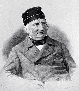
Friedrich Georg Wilhelm von Struve was a Baltic German astronomer and geodesist. He is best known for studying double stars and for initiating a triangulation survey later named Struve Geodetic Arc in his honor.

Otto Wilhelm von Struve was a Russian astronomer of Baltic German origins. In Russian, his name is normally given as Otto Vasil'evich Struve. Together with his father, Friedrich Georg Wilhelm von Struve, Otto Wilhelm von Struve is considered a prominent 19th century astronomer who headed the Pulkovo Observatory between 1862 and 1889 and was a leading member of the Russian Academy of Sciences.

A geodetic datum or geodetic system is a global datum reference or reference frame for precisely representing the position of locations on Earth or other planetary bodies by means of geodetic coordinates. Datums are crucial to any technology or technique based on spatial location, including geodesy, navigation, surveying, geographic information systems, remote sensing, and cartography. A horizontal datum is used to measure a location across the Earth's surface, in latitude and longitude or another coordinate system; a vertical datum is used to measure the elevation or depth relative to a standard origin, such as mean sea level (MSL). Since the rise of the global positioning system (GPS), the ellipsoid and datum WGS 84 it uses has supplanted most others in many applications. The WGS 84 is intended for global use, unlike most earlier datums.

A triangulation station, also known as a trigonometrical point, and sometimes informally as a trig, is a fixed surveying station, used in geodetic surveying and other surveying projects in its vicinity. The nomenclature varies regionally: they are generally known as trigonometrical stations or triangulation stations in North America, trig points in the United Kingdom, trig pillars in Ireland, trig stations or trig points in Australia and New Zealand, and trig beacons in South Africa.

Arc measurement, sometimes degree measurement, is the astrogeodetic technique of determining the radius of Earth – more specifically, the local Earth radius of curvature of the figure of the Earth – by relating the latitude difference and the geographic distance surveyed between two locations on Earth's surface. The most common variant involves only astronomical latitudes and the meridian arc length and is called meridian arc measurement; other variants may involve only astronomical longitude or both geographic coordinates . Arc measurement campaigns in Europe were the precursors to the International Association of Geodesy (IAG).

The Struve Geodetic Arc is a chain of survey triangulations stretching from Hammerfest in Norway to the Black Sea, through ten countries and over 2,820 kilometres (1,750 mi), which yielded the first accurate measurement of a meridian arc.
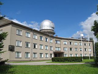
The Tartu Observatory is the largest astronomical observatory in Estonia. On 1 January 2018, Tartu Observatory was joined again to the University of Tartu, and the observatory is now an institute of the university. It is located on the Tõravere hill, about 20 km south-west of Tartu in Nõo Parish, Tartu County. The old Tartu Observatory, located in Tartu city centre, is known internationally for its connection to Friedrich Georg Wilhelm von Struve and the Struve Geodetic Arc, of which it is the first reference point.

Aavasaksa is a sharp-edged hill in Ylitornio municipality in Finnish Lapland. It has an elevation of 242 metres (794 ft). Aavasaksa is famous for its sights both towards Finland and Sweden, and it is included in the list of the National landscapes of Finland. Decorative hunting cabin "Imperial Lodge" (Keisarinmaja) is one of the buildings on top of the hill. Its construction began with a visit by Alexander II of Russia in mind, but due to political instability it never happened. It's only open in the summer.

Rudi is a village in Soroca District, Moldova.
The Rudi (Rughi) Monastery is a monastery in Rudi, Moldova. It was established in Moldavia, in 1777.
Võivere is a village in Väike-Maarja Parish, Lääne-Viru County, in northeastern Estonia. It has a population of 49.

Simuna is a small borough in Väike-Maarja Parish, Lääne-Viru County, in northeastern Estonia. It had a population of 454 as of 2011.
Fuglenes is a district in the municipality of Hammerfest in Norway. It is the location of the northernmost point of the Struve Geodetic Arc. It is a geodetic point, one of the 34 points selected for the World Heritage List. It was here that Friedrich Georg Wilhelm von Struve's surveys ended in 1852.
This page is based on this
Wikipedia article Text is available under the
CC BY-SA 4.0 license; additional terms may apply.
Images, videos and audio are available under their respective licenses.


